StructureSpot

Concerns still abound regarding Izard County sand mining

By Susan Varno

Sunday, May 22, 2011

Mill Creek is shown after George Bartmess stripped vegetation from the bank in 2008. His property ends where the trees and vegetation begin.

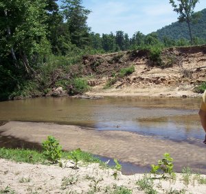
Photo by Susan Varno / Contributing Writer

Mill Creek is shown after George Bartmess stripped vegetation from the bank in 2008. His property ends where the trees and vegetation begin.

THREE RIVERS AREA — The roar of a bulldozer on the banks of Mill Creek alerted residents in Izard County that their lives were about to change dramatically.

In February 2008, landowner George Bartmess stripped most of the vegetation from the creek bank on his property. He even plowed up some of the creek bed. Heavy rains washed sand and silt into the creek and downstream into Piney Creek. Piney’s gravel creek bed filled with sand and mud, threatening the smallmouth-bass habitat.

Barbara Carlson, who lives nearby, said Bartmess’ actions got the attention of his neighbors.

“Local people didn’t know Bartmess was planning to do sand mining,” Carlson said. “We came together and asked Friends of the North Fork and White River to help us understand the laws and environmental problems.”

The Friends helped residents form a chapter, Friends of Mill and Piney Creeks. Members of the new organization spent months studying frac sand mining, state and federal laws, and the permitting process.

They learned that B&H Resources LLC of Shreveport, La., had applied to the Arkansas Department of Environmental Quality for a quarry sand-mining permit. Beneath southern Izard County are thousands of tons of high-grade silica sand. Today, it is in demand as “frac sand,” used to help release natural gas from gas shale.

“We realized what Bartmess was doing was illegal,” Carlson said. “He was allowed to do nothing until his permit was approved.”

The group informed the ADEQ of Bartmess’ activity, and the department issued an emergency “cease and desist” order on June 19, 2008. Responding to the Mill and Piney Creeks group’s complaints, the Arkansas Game and Fish Commission ordered B&H to repair damages along Mill Creek.

“A small group became active,” Carlson said. “We tried to educate the public and publicize what was happening. Word was spreading. People were alarmed.”

Company owner Mike Hardy was the “H” in B&H. Bartmess was the “B.”

“After the cease-and-desist order, we had issues with Bartmess,” Hardy said. “We bought him out and reorganized as Evergreen Processing LLC. We had to start the permit process all over. We have voluntarily held public meetings since we began the permitting process.”

About 130 local residents attended a meeting on Oct. 5, 2009, at the Calico Rock Music Hall. Evergreen sent its consultants to outline plans for the 1,300-acre mining site. Engineer Dan Drinkwater said the quarry would cover about 300 acres. To wash the sand, the plant would use about 390,000 gallons of water a day, drawn from 2,000-foot-deep wells.

Concerned that using so much water would dry up homeowners’ wells, Friends of Mill and Piney Creeks invited John Czarnecki of the U.S. Geological Survey to a public meeting on Feb. 18, 2010, in Calico Rock. Czarnecki said the volume of the Ozark Aquifer, which flows beneath northern Arkansas, has never been measured for Izard County, so it is not known if there is enough water to support sand-mining operations.

Hardy said after the meeting that he asked his consultant geologist, David Williamson, to meet with Czarnecki to investigate the dynamics of the aquifer.

“We have 18 springs on the Evergreen property,” Hardy said. “The second-largest spring runs well and has about the same flow in wet and dry years. We asked the Arkansas Natural Resource Commission to look at the spring, and they felt it was a better fit. It will cost us more to build a five-mile-long pipeline with four pumps to move the water from the spring to the plant, plus yearly maintenance. We made the change because it just made sense.”

At the October 2009 meeting, Evergreen consultant Kevin Ware said that after the sand is washed, the water will be pumped into retention ponds. Polyacrylamide would be added to bind with the sediment and make it sink. Some of the “clean water” would be reused. However, an ADEQ permit allows the release of “clean water” into creeks that eventually flow into the White River.

Jeff Williams, trout biologist for Arkansas Game and Fish, spoke next. He said trout become stressed when temperature, turbidity, chemicals and/or sediment levels of river water change. The fish don’t feed or spawn well and are more likely to die.

Responding to these concerns, Evergreen redrew its plans over the next year.

Hardy said the new plan does not use sediment-binding chemicals.

“We will bring water into a slurry, which presses the sediment into clay bricks,” he said. “The used water will go into two ponds, 4 acres each, with a berm around them.”

The bricks will be used to refill the quarry.

Evergreen will also use much less water.

“We will draw water from the ponds back into the plant, only adding water for condensation and evaporation,” Hardy said. “When we start this plant, we will become part of this community. Questions and concerns from meetings quickened our decision to make some changes. We felt the changes would have less impact and be more sustainable.”

On Jan. 25, ADEQ held a public hearing at Calico Rock City Hall on Evergreen’s discharge and pond-construction permit. The company’s revised plan includes using spring water and storm water and only cutting trees and vegetation for roads, the quarry and the plant.

More than 60 people attended the hearing. In response to questions from the audience, Mo Shafii, ADEQ Water Division assistant chief, said the department, which is responsible for 6,000 permits and has only 15 inspectors, is only required to inspect a permit site once every five years.

“Permits are a self-policing system,” Shafii said.

However, the agency usually responds to complaints from the public within three days, Shafii.

According to media reports, in March, Evergreen completed planting 15,000 river birch, silver maple, sycamore and red oak seedlings and a variety of shrubs as part of the rehabilitation plan that Game and Fish ordered along Mill Creek.

Carlson said local residents will have to monitor what the plant discharges into the streams near the quarry.

“We have been effective because we approached all that was happening with calmness and rationality, asking how we could minimize the impact of sand mining,” Carlson said. “My feeling is, let’s try to protect the environment on the front end, so we won’t have to fix it on the back end.”

Kenneth Ballman, justice of the peace from Horseshoe Bend, also has concerns about Evergreen and the other two frac sand-mining operations in Izard County.

“Sand mining will contribute to the local economy,” Ballman said. “At Guion, 30 to 35 jobs; Evergreen, 30 to 35 jobs. Short-term, this will be good for our economy, but the long-term impact could be worse. I would like to see a study of the aquifer.”


Viewpoint – Water council supports RAR bylaw

By Contributed Opinion – Gulf Islands Driftwood

Published: May 25, 2011 10:00 AM

Recent criticisms about the proposed Riparian Areas Regulation (RAR) bylaw and the process for its implementation seem to have lost sight of its primary purpose. That is, to regulate activities on land that could result in contamination of critically important streams, lakes, wetlands and other water courses. Surely public health, in the form of safe, healthy water sources on our island, must be a clear priority.

The Salt Spring Island Water Council, comprising over 50 organizations, agencies and individuals involved with providing, protecting, conserving and managing drinking water on the island, strongly supports the overall intent of the proposed bylaw. We recognize that protection of fish habitat through the implementation of the RAR will also have the effect of enhancing the protection of our drinking water.

Water Council also agrees with the creative efforts of the Local Trust Committee to implement the bylaw in a way that would reduce the costs to applicants and expedite the approval process, provided it does not compromise public health concerns in the protection of vital drinking water supplies.

I’d like to address some of the criticisms being raised about the proposed bylaw.

The suggestion that this bylaw is being rushed through the process is emphatically wrong. The requirement to comply with the provincial RAR was made in March 2006 and, perhaps, should have been addressed in my term as a local trustee for the Islands Trust (2005-2008). However, a review of the development permit areas was planned but not undertaken over this period due to considerable work on other revisions to the OCP. Another two and a half years have passed. With extensive public input, a revised Development Permit Area 4 bylaw, incorporating RAR, has been proposed and is long overdue.

Concerns have been expressed about the scale of mapping that is needed. Since RAR applies to all defined “streams,” whether mapped or not, detailed mapping is not necessary to implement RAR. However, the Trust has proposed a reasonable compromise by identifying RAR designated watersheds on the island, within which the RAR would apply to a 30 m setback from any “streams.” In practice, according to staff estimates given in last week’s Driftwood, less than 10 per cent of the island land base could be affected.

Critics have proposed more certainty for landowners through detailed mapping of all possible “streams” that would be subject to RAR including ground-truthing and private landowner consultation. The costs are unknown, but likely high for the taxpayer and would further delay the bylaw. Even with such mapping, a site-specific assessment by a Qualified Environmental Professional could still be required for each application, at the applicant’s expense, at the time the application is made. Given the relatively few development permit applications that are filed and the proposal to have Trust staff provide an initial screening of applications, the proposed watershed mapping appears to be the most cost-effective approach.

I was pleased to read in last week’s Driftwood that the Trust is exploring a way to address the sensitive issue of roadside ditches, perhaps through a clear definition of ditches that would be subject to RAR with reduced setbacks and those that would be exempt. This would reduce the area of land affected even more.

In view of the above, and the urgency of protecting our increasingly threatened drinking water sources, Water Council urges the Local Trust Committee to proceed diligently with a final bylaw at the earliest opportunity accompanied by the proposed community information program to assist landowners and the development community.

Peter Lamb is coordinator of SSI Water Council and a former Islands Trustee.


Fishiding teams up with crappie and bass fisherman nationwide!

Not only has fishiding artificial fish habitat been used in private lakes and ponds for aquatic balance, but the pro’s in bass and crappie fishing on getting on-board fast. Since hitting the market just over two years ago, fishiding artificial fish attractors are taking fish habitat to a whole new level. For years fisherman and pond owners have been putting an array of products in their waters to provide much needed habitat for fish and aquatic life. Natural wood products continue to be used with success, only for a limited time. The industry has turned it’s direction towards artificial pvc products that won’t rot and stay forever in place.

The west Virginia Bass Federation has begun a pilot program with the fishiding fish habitat products to see if they can resolve a problem they have in many of their waters. Seems that they have trouble getting algae to grow quickly if at all on fish structure they have used in the past. These guys and gals put in countless hours of their own time to build, install and maintain hundreds of fish structures throughout the state.

What we know about fishiding is that it grows algae fast everywhere it has been installed, now in over 40 states. High water and flooding has kept the units from being installed but soon will be in the water holding fish. Much better than buried in a landfill.

The Bass Federation is hoping to install fishiding artificial fish habitat products throughout the state waters as well as all the states but two in the nation. Only Hawaii and Alaska do not have a Bass Federation chapter , with all the others eagerly involved. Stay tuned for results and information as to where the units have been installed.

Recently, fishiding.com was contacted by the West Alabama Crappie association and the Tenn Tom Crappie Club to sponsor their next two tournaments. These folks love to fish and install habitat, especially for crappie. Numerous sizes and models of fish habitat made from reclaimed pvc will be raffled off and awarded to winners at various events. Fishiding products are all made with an entirely green approach from the pvc material to the cardboard and newspaper used in shipping. All measures are taken to re-use and reclaim products to save the environment as well as the final cost.

Fishiding.com offers sizes of fish habitat from small Koi and garden pond fish made from fine strands of pvc, to large 84″ diameter fish attractors with wide flat limbs to cast maximum shade for the largest of predators.

Coming soon will be pre-packaged bundles of rigid sticks of pvc to be used as stakebeds. This stiff, long lasting material will hold crappie right where you want them and only you will know the spot.

Another often forgotten or looked over step in the process is actual fish habitat design. In the past only a few types of artificial fish habitat were available and manufacture’s seem to assume folks know what to do. We have learned that there is a great deal of thought that can and should go into habitat placement planning. With the various sizes, textures and shapes of fish attractors fishiding.com now offers, the blueprint for sucesss has never been so attainable. Depending on a clients goals, many choices are available. Shallow water cover to protect and grow fry and forage is now available exclusively with the fishiding cradle and garden pond sizes. Mid depth fish structure comes in the safehouse model, designed to give fish a route to follow as they move from 2-4 foot depths in to the 6-10 foot range. Once fish have grown to the optimal predator size, they will hide and hunt in the deeper water on the edge of the main lake basin. This is where the keeper model excels in holding large fish.


No matter what your goals are, or what shape your fishery is in, fishiding.com has fish habitat custom tailored to help your fish grow big and healthy. We will work with your budget to come up with a plan to keep your fish safe ,happy and full. After all, it’s about the fish.

TABLE ROCK LAKE FISH ATTRACTOR LOCATIONS

TABLE ROCK LAKE FISH ATTRACTOR LOCATIONS UPDATED WITH 2011 FISH ATTRACTORS

The following link directs you to a web site that displays Table Rock Lake fish attractor locations. This site is a partnership between the U.S. Army Corp of Engineers and the Missouri Department of Conservation. Using the Map Identify tool you can see the latitude and longitude of the fish attractor. Use this link, Table Rock Lake Fish Attractor Locations


Largemounth bass study underway at Table Rock

Largemouth Bass


Please Credit “Courtesy Missouri Department of Conservation”

News from the Southwest region

Published on: May. 19, 2011

Posted by Francis Skalicky

SPRINGFIELD MO — The Missouri Department of Conservation (MDC) and the University of Missouri are working together on a radio-telemetry study that will provide information about behavior and habitat use of largemouth bass.

Tracking of the tagged fish will begin this month (May) and will continue through 2012. Each fish will be located once per month during daylight hours. Once every three months, a smaller number of the tagged fish will be tracked for a full 24-hour period to monitor daytime and night-time movements. Once each fish is located information will be recorded such as GPS location, distance travelled from last location, depth and habitat use.

Earlier this year, 60 legal-size (greater than 15 inches) largemouth bass were collected from the Kings River arm of Table Rock and surgically implanted with radio tags. After the fish recovered from their surgeries, they were released back into the lake.

A tagged fish can be identified by a radio-tag antenna coming out of the body cavity and sutures near the fish’s abdomen. Besides a radio tag, each bass in the study was also tagged with an orange tag near the dorsal fin. This tag has a five-digit number unique to each fish. Anglers who catch tagged fish should contact the MDC at 417-334-4859 or e-mail MDC Fisheries Management Biologist Shane Bush at shane.bush@mdc.mo.gov.

When reporting a tagged fish, individuals should provide:

  • Number from the orange tag.
  • Length and weight of the fish.
  • Location the fish was caught (GPS coordinates if possible).
  • Overall condition of the fish.
  • Approximate depth the fish was caught at and if it was near a habitat structure (if known.)
  • If the fish was released or harvested.

This study is part of the Table Rock Lake National Fish Habitat Initiative, a project designed to maintain and improve fish habitat in Table Rock.

Since 2007, the MDC has placed more than 1,500 fish habitat structures in the lake. These structures were marked using GPS. Locations of these structures can be found athttp://newmdcgis.mdc.mo.gov/tablerock.

The NFHI project is a joint effort of the MDC, the National Fish and Wildlife Foundation, Bass Pro Shops, the U.S. Army Corps of Engineers and other organizations. It is a pilot project for a broader national program focused on habitat protection and restoration in reservoirs throughout the country.


Dark side of the Driftless

May 20, 2011 Our Stories No Comments E-mail This Post E-mail This Post
By Matt Hrodey

A new study by the U.S. Fish and Wildlife Service says the potential for damage to fish habitats in the Driftless area of Wisconsin, a hilly region in the state’s southwestern reaches, is great, and the damage may have already been done. The findings come from a national survey of fish habitats released earlier this month.

DRIFTLESS FARM (PHOTO BY UW-STEVENS POINT) 

The Driftless area spans about 24,000 square miles and includes portions of southwestern Wisconsin, southeastern Minnesota, northeastern Iowa and northwestern Illinois, according to the agency. Because the region wasn’t raked flat by the last continental glacier, it’s full of rolling hills and spring-fed streams.

“Just minutes northwest of the state capital, the roads curve gently and the hills begin to rise invitingly,” said a recent story in Milwaukee Magazine. “Before long, there are Holsteins and horse farms, an occasional orchard, a flock of sheep as pale and fluffy as an earthbound cloud.”

The region’s agriculture, however, may be a detriment to its native fish habitats.

Using a variety of factors – including the presence of urban development and the density of farming, livestock, industrial pollution sources and habitat “fragmenters” such as dams and road crossings – the study calculates the risk for “fish habitat degradation” in watersheds.

DRIFTLESS AREA (BY NATIONALATLAS.GOV) 

Most of the state’s southern half is said to be at “high” risk of degradation, but the largest swath of “very high” risk lies in the Driftless.

According to the Fish and Wildlife Service, “Poor land and water management practices including intensive row crops, fertilizer use, channelization, water withdrawals, loss of perennial vegetation and invasive species have caused excessive stream bank erosion, sedimentation and poor water quality.”

The affected area includes the Mississippi River. The Driftless pollution impacts its waters “all the way to the Gulf of Mexico,” according to the study, contributing to low oxygen levels downstream.

The federal agency isn’t saying the region’s waterways are damaged or not, only that there’s a “very high” probability that they already are.

As reported in NewsBuzz, the state Department of Natural Resources recently caught a grass carp, a plant-devouring invasive species, in the Lower Wisconsin River within the Driftless area. Officials believe it had migrated from the Mississippi River during a period of spring flooding.

Trout Unlimited, a national nonprofit funded by sport fishermen to support conservation, has organized the Driftless Area Restoration Effort to “protect, restore, and enhance rivers and streams for fish and other aquatic life throughout the Driftless.”


Small Fisheries Revitalization Using Largemouth Bass (Micropterus salmoides) as an Indicator Species

Eldon Peters

Environmental Biology and Mathematical Modeling

Instructor: Shannon Leissner   Assistant: Shana Funderburk

Largemouth bass are a good indicator of pond health and will specify the health of the tested pond after the treatment of any adversary conditions.  The study follows the set guidelines obtained by Brady (1981) to determine the procedure needed to correct any problems concerning the pond.  The study involved treating any flaws related to the pond and monitoring its effect on the bass caught.  The bass were then compared to the pre-treatment bass to determine the effect of the revitalization.

Ponds offer an excellent setting in which to study aquatic ecosystems simply for the reason that you can control many of the variables. Because largemouth bass (Micropterus salmoides) are the top predator in a pond, they are affected by everything that lies beneath them on the food chain. This makes largemouth bass one of the best indicators of problems within a pond.  The data gathered in this experiment will specify the elements that need to be added or changed to create healthy pond, which will be indicated as it becomes a good fishing resource for largemouth bass.

There are many factors that contribute to the health of a pond.  Fish attractors such as brush should be placed at different depths throughout the pond.  These attractors will allow a place of ambush for large fish and a refuge for smaller fish.  The shallowest part of the pond should only be two feet deep; this depth will prevent the growth of foreign aquatic weeds.  The temperature should range between 64 and 90 degrees Fahrenheit in order to promote maximum fish growth.  Fish will tolerate a pH range of 4.6 to 11, but will thrive in water with a pH of 6.5 to 9.0.  One side of the pond should be shaded and the other should be open to the wind to churn the water and produce oxygen.  There should be enough phytoplankton to cloud the water, which will indicate that there is a sufficient amount of oxygen to sustain aquatic life (Oster, 1983).

In order to manage a productive pond one must understand the delicate balance of the ecosystem in the pond.  Located at the bottom of the food chain are plants called phytoplankton which use chlorophyll to produce food.  Zooplankton feed exclusively on phytoplankton.  Smaller baitfish feed on zooplankton.  Bream feed on small baitfish, insects, and worms.  Largemouth bass feed on anything from four-inch bream to large snakes (Oster, 1983).

Once a pond is considered unhealthy, a number of tests are run to determine the procedure needed to revitalize the pond.  The pH of the water must be tested.    If the pH is too low, limestone can be added at a ratio of one ton per acre to raise the pH by one unit.  Unfortunately nothing can be done to remedy a high pH (Brady, 1981).

An additional test is needed to determine the quantity and type of phytoplankton present in the pond.  Phytoplankton play a key role in producing oxygen.  If the population of the phytoplankton is too low, the oxygen level will decrease causing fish kills.  Therefore fertilizer must be periodically added to promote the growth of the phytoplankton, but can only be added when the temperature reaches 65 degrees Fahrenheit.  Pond fertilizer is composed of four parts phosphorus, four parts nitrogen, and two parts potassium.  The fertilizer may be applied anywhere between six and sixteen times a year, depending on the natural fertility of the pond (Brady, 1981).

If there is an overgrowth of phytoplankton, it will block the sunlight that other aquatic plants need for photosynthesis.  When the plants die, bacterial decomposition drains the pond of oxygen.  This oxygen depletion will have a devastating effect on fish.  To counteract the increase of phytoplankton, lime is added to slow the population growth (Pond Management Guidebook, 1989).

Oxygen deficiency is deadly to a pond, but it is easy to fix.  A test kit is used to find the oxygen level of the pond.  If the level is too low, an aerator puts fresh water back into the pond.  The added water should be sprayed through the air so that it causes a splash as it hits the water to intensify the oxygen content.  Another way to increase the oxygen level is to pump water from the bottom of the pond into the aerator.  The oxygenated water, located at the surface, will then shift to the bottom at a faster rate.  The water at the base of the pond will pass through the aerator and back to the surface creating a cycle (Pond Management Guidebook, 1989).

The main food for the largemouth bass in a pond is small bream that spend much of the summer in the vegetation.  If the aquatic plants are too dense, the bream will escape from the bass that are waiting to ambush its prey.  If all the vegetation is removed, the pond becomes oxygen deprived, and the bass lose their places of ambush.  The vegetation must be controlled to provide the optimum conditions for the fish.  Herbicides or aquatic mowers can be used to trim the population, and fertilizer can be used to boost the plant population (Oster, 1981).

In a proper ecosystem, there is a delicate balance between the predator and the prey.  Within the pond, the bass must feed on bream, or the bream will eat the bass eggs and decimate the population.  If the bass population is too large, the bream population will decline and the struggle for food will increase (Fig. 1) (Pond Management Guidebook, 1989).

Study Question

The purpose of this study is to correct the problems within a pond that have contributed to the reduction in fish population over the past three years.  A drop in the number of fish caught indicates a decline in water quality.  Once the problems are fixed, the number of fish will increase along with water quality.

Study Site

This study involves a man-made pond that has a small population of underweight bass.  The pond spans four acres and ranges from 0 to 12 feet deep.  The only wooden structure of the pond is a massive brush pile is at deepest part and lines the entire bank. The edges of the pond present shade on one side and an open bank, where the wind churns the water, on the other.  Water opposite the levy is shallow and offers a place for the fishes to spawn and feed.  The pond is sufficiently fertilized because there is an ample amount of vegetation and phytoplankton growth.

Methods

The methods described in Brady (1981) will be implemented to increase the number of fish caught and ultimately improve the water quality.

Results

The number of largemouth bass caught after pond treatment compared to the number of largemouth bass caught before treatment will indicate the health of the pond.  Lime, aquatic mowers, and  modified topography will be used to correct different problems related to the pond if necessary.

Conclusion

When all of the problems within the pond are corrected, the amount of largemouth bass caught should increase along with a physical growth of all the species.  The number of fish caught will serve as an indicator of pond health, and therefore of water quality, which is a major concern of people today.

Works Cited

Brady, P. 1981.  Pond Management for Sport Fishing in Arkansas.  U.S.D.A. Soil Conservation Service.  Pages 31-32, 34, 39, 43-47, 49-50.

Pond Management Guidebook. 1989.  NC Wildlife Resources Commission. 23 pages.

Oster, D.  1983.  Largemouth Bass.  Cy DeCrosse Incorporated.  Minnetonka, Minnesota. Page 8-16, 20, 36, 38, 89-126, 135-152.


Fish Caught

Population Condition

Only recently hatchedBass overcrowded
bream.
Mostly 3″-5″ breamBream overcrowded
Young bass, hatched
bream, few 3″-5″Balanced population
bream.

Fig.-1: Conditions of largemouth bass population based on number and type of

fish caught in a seine (Pond Management Guidebook, 1989).


A tale of 10 trout

Published Saturday May 21st, 2011
A7
R. Allen Curry
Commentary

The fishing season is upon us and when the spring flood recedes this season, New Brunswick’s brook trout will face a new onslaught of apparently starving anglers.

Click to Enlarge
Photo: Images NB
Fishermen cast for trout on Lac Baker. The provincial government’s decision to double the catch limit for brook trout in northwestern New Brunswick has raised questions about whether cabinet is playing politics with conservation.

The Minister of Natural Resources, backed by the premier, has increased the number of trout that can be harvested by an angler each day from five to 10 in the streams and rivers of northwestern N.B. According to the minister, he has good data for the trout populations and he is 100-per-cent confident the data demonstrates that doubling the harvest is sustainable. He stated that not all his biologists agree his decision is in the best interest of the trout populations. In addition, his local MLAs asked their constituents if they believed this would be a good decision and some of them thought it was a good idea.

It appears the minister is unsure of the sustainability of the increased harvest, because he is also quoted as promising more stocking of hatchery raised trout to help sustain these populations if they become depleted by harvesting.

Every new government has new ideas and approaches to managing our society’s assets, things like our health care, education, economy, and our environment. This particular tale of 10 trout shows our newest government in action and sends a clear message about Premier Alward’s approach to managing our assets.


Five trout, or 10?

The tale begins with a decision based on the proclaimed accurate data. How many fish can we harvest is a question asked by all fisheries managers, and indeed provincial staff are working hard and doing what they can, with very limited people and finances, to set harvest levels across the province. I have published a few scientific papers on N.B.’s brook trout populations, completed some population estimates on these northern and other populations, and have visited many brook trout streams here and across their range, so I asked to see the data the minister used to make his decision.

It won’t surprise you to know that with the continuing reductions in DNR staffing and their operational finances for fish and wildlife monitoring, the actual data is quite limited. It has many gaps, it is highly variable, and the methods for data collection are inconsistent. That doesn’t mean tables and diagrams for reports and presentations can’t be generated, but the results are impossible to interpret and therefore the data are unreliable.

There is data not discussed by the minister, which is staff surveys of how many anglers are out there and how many trout they are taking (angler effort and harvest rates). The existing data have the same quality control issues mentioned, but they tell a consistent story the biologists all agree is real.

In the northwest, anglers on average harvest seven trout per day, and elsewhere the harvest is less than three trout per day. In other words, that region’s trout populations are already under more harvesting pressure than populations elsewhere in N.B.

The statements made by anglers when they are surveyed and documented in reports bear this out: “I will catch 10, bring them back to the camp and then go back to get more.” Critical to decision making, but missing in reports and the minister’s comments, are analyses to show how many trout in total will now be harvested, how that will be monitored, and if increasing the harvest by 100 per cent (five to 10 trout) is sustainable, especially given the known pressure on these populations.

The minister indicated that more stocking of trout in the northwestern streams could occur next year to “help sustain the trout population(s).” If you read the minister’s policy for stocking fish it states, “DNR’s fish management strategies focus on responsible management of fish habitat and fish populations to promote natural reproduction of wild fish populations.”

The policy goes on to state, “it is important that the department consider all other management options prior to stocking.” The easiest option is controlling the harvest by anglers. And, implicit in the policy is that stocking streams is not a preferred option unless the stream supports a sea-run population of trout, which don’t occur upstream of the Mactaquac Dam near Fredericton.

If the northwestern brook trout populations can sustain a 100-per-cent increase in harvesting, why would DNR have to stock non-wild, hatchery trout and additionally, take this action against their policy?

The minister has stated that not all of his biologists agree with an increased trout harvest. He didn’t tell us if that was the majority opinion.

The last of the minister’s statements, and one that the Premier and other ministers are using for other issues, is their consultation with MLAs and their constituents. For the people they talked with, the “reaction was overwhelmingly positive” in favour of increasing the trout harvest.

I’m certain the majority of NBers would overwhelmingly support a reduction in taxes, but that doesn’t make it a wise choice for a sustainable province.

I know many people not in favour of increasing the trout harvest, but they may not have been the loudest voices heard by the minister and Premier. Consultation is an important element for any government initiative, but selective questioning or listening is not the best method to consult, report and act.


Act with caution

I’m obviously concerned about the brook trout, because I have no confidence that we understand the consequences of increasing the harvest in this region. If we can’t predict the outcome, then most of us would recommend erring on the side caution until we learned more to improve our likelihood of making the correct decision.

Take, for example, another fish issue, the cod fishery of eastern Canada. Scientists and many fishers stated their concern about continuing to increase harvests, and the decision makers chose to go against this advice. The result was the collapse of those populations and the fisheries they supported, which became both an ecological and economic disaster.

That doesn’t have to be the case in this situation. If the minister wants to change the harvest, an investment in accurate assessments and monitoring for a few years would produce the actual information needed to make a decision that sustains our fish populations and the fisheries they support.

Will the world end if brook trout populations in northwestern N.B. are lost? The answer is no, but by depleting these populations we increase the stress on their ecosystems and degrade the fishing quality and opportunities that were, after all, the original intent of the minister’s actions.

One final item that is disconcerting in this tale of 10 trout is the consistent, low priority placed on the environment by the current governing political party. In addition to the brook trout, this government (even if it didn’t start the process) has decreased the protected forest areas for deer and protecting water, undermined their protection of wetlands, allowed shale gas exploration despite unequivocal concerns for contaminating groundwater, and permitted direct pollution of waterways to allow mining opportunities to proceed. All of these actions are against the spirit of our provincial laws that protect the environment, but this government and prior governments repeatedly invoke discretionary, opt-out-of-the-law clauses provided to ministers. It would be interesting to know how many times this occurs, who benefits, and why.

In fairness to the politicians we elect, it is their job to make decisions regarding how society will operate. In fairness to the people who elect them, politicians should be completely transparent about how they made their decisions.

If a decision to increase brook trout harvests in northwestern N.B. is made because the cabinet believes the majority of voters want it to happen, then just say that despite the best advice of your staff and the majority of experts, your decision is political.

If you make a decision to develop and lose a wetland or pollute one of our waterways, just tell us publicly the reason why. Your honesty would allow people to debate and provide governments with informed opinions about how to manage our society. Indeed, it would be the best solution if the cabinet (and all cabinets) would tell us what political and dollar value it is placing on the loss of a wetland, a stream ecosystem, or a trout population. That knowledge and honesty would go a long way in educating the people whom you represent and garnering their support for your decisions.

Everything I have read and heard about Premier Alward leads me to believe he is an honest person with a desire to bring honesty and transparency to his role as leader of our province.

So far, Premier Alward’s government has yet to demonstrate a willingness to be honest and transparent about his decisions regarding our environment.


R. Allen Curry, Ph.D. is a Professor of Recreational Fisheries and Director of the Canadian Rivers Institute at UNB.

Please Log In or Register FREE

You are currently not logged into this site. Please log in or register for a FREE ONE Account.
Logged in visitors may comment on articles, enter contests, manage home delivery holds and much more online. Your ONE Account grants you access to features and content across the entire CanadaEast Network of sites.


Public Works Builds Fish Habitat in Upper St. Clair

The stream in front of the post office will now be better for fish life.

By Becky EmmersEmail the author | May 20, 2011

The Upper St. Clair Public Works department teamed up with the Pennsylvania Fish and Boat Commission during National Public Works Weekto help improve the stream that runs in front of the post office along McLaughlin Run Road.

“We had a need for some bank stabilization,” said Dave Kutschbach, superintendent of projects for the public works department.

The organizations worked together to design a project that stabilizes the bank and creates a fish habitat.

“We created structures that directs the water down the center,” Kutschbach said.

Channelizing the stream will prevent bank erosion along with providing structures for the fish to live under.

“The structures create some overhead cover for the fish to stay away from predators like birds and raccoons,” said Jon Thomas, from the Pennsylvania Fish and Boat Commission.

Thomas said the new structures give the possibility of creating more fish life in the stream.

“There isn’t much here right now, but they’ll start to congregate,” Thomas said.

The fish include basic minnows, daces and carp, he said.

“The structures will stop sediment from going into the streams and make the water better for the organisms,” said Keith Beamer, of the Pennsylvania Fish and Boat Commission.

The Allegheny County Conservation District was also involved with the project.

“It provides dual benefits. Better relationships develop between the township, nonprofits and state organizations,” said Amy Miller, of Allegheny County Conservation. “And it results in a cleaner stream. There’s going to be less sediment so that means less flooding. And it makes it prettier.”

“This project is an example of the township’s commitment to conservation and clean streams,” Kutschbach said.

The public works department also celebrated National Public Works Week with an open house for kids and the community. Click here to read the article.


Fishiding helps Premier Outdoor Properties,Inc. improve fish habitat

cribs ready to go
We recently sent a custom artificial fish habitat arrangement to Nebraska to be installed in Aaron Graham’s personal pond at his home.  Aaron and his two boys stayed up late the night they arrived, each of them creating ther own personal fish attractors by bending them into shape.  We put together a plan for him with a lake map he provided showing depth, contour and swimming areas. After the habitat has been installed, the boys will be sure to let us know how they are doing.
Below you will find an excerpt from a recent premier outdoor properties blog.
"Graham Lake Bass"

Check out this product to create a fish habitat in your pond…and be “green”!!

Written by admin on May 18th, 2011

Fishiding

Spend a little time on this website to learn more about the “green” solution to cost effective fish hiding units!  This company uses “reclaimed products to reclaim habitat”–an amazing new use for vinyl siding!!    http://www.fishiding.com/

Posted in MiscellaneousNo Responses »
Tags: 

“Cast A Fly…Catch A Student” National Fishing in Schools Program

Written by admin on May 17th, 2011

http://flyfishinginschools.org/mission.htm

Check out this website!!   Be sure to pass this information along to officials at public or private schools, government agencies or non profit organizations that would benefit from this worthwhile program, which provides teachers with all the tools they’ll need to:

  • teach youth how to fish
  • experience outdoor activities and
  • gain a respect for our natural resoures

“Cast A Fly…Catch A Student”.    NFSP, National Fishing in Schools Program

Posted in MiscellaneousNo Responses »

Double Duo–Spring Fling Trophy Shoot Event

Written by admin on April 15th, 2011

spring fling trophy shoot event

Posted in MiscellaneousNo Responses »
Tags: ,

Check out the latest educational opportunities available through the Nebraska Game & Parks Commission! There’s something for everyone!

Written by admin on April 15th, 2011

Posted in MiscellaneousNo Responses »
Tags: 

The Big Bucks are on their way!!

Written by admin on March 15th, 2011

The Nebraska Big Buck Classic is just a little over a week away!  Plan now to attend the show where you’ll be able to take in all the latest trophy bucks and view Monster Bucks of the Past–proudly sponsored by Premier Outdoor Properties Inc!  Be sure to stop by our booths #728-729 and say hello–we’d love to visit with you!  Show hours are Friday, March 25, 4pm-9pm; Saturday, March 26, 9am-8pm and Sunday, March 27, 10am-4pm.   Be sure to visit our homepage and enter for a chance to win a pair of tickets for FREE ADMISSION to the event!   We’ll see you at the show!!

Posted in MiscellaneousNo Responses »
Tags: 


Scroll to Top