StructureSpot

New Man-Made Reefs Heading To Gulf Floor

Man-made reefs similar to this will be deployed off Escambia County between now and June, 2019.
CREDIT ESCAMBIA COUNTY MARINE RESOURCES

More than 700 new artificial reefs are going into the waters off Pensacola in the next few months, in phase two of a program funded by the BP settlement of the 2010 oil spill.

According to the Florida Fish and Wildlife Conservation Commission, for every dollar spent on artificial reefs in the Florida Panhandle, the conservative overall economic benefit is roughly $138.

“We’ve been trying to do this the whole time I’ve been on the [Commission]; actually, even before I got on the Board Escambia County had taken a fairly aggressive position on reefing,” said Escambia County Commissioner Grover Robinson, who chairs the Gulf Consortium, 23 Florida counties affected by the Deepwater Horizon explosion and resulting oil spill.

The money’s coming from the Natural Resource Damage Assessment, NRDA, which is aimed at compensating for environmental damages in those counties.

“When NRDA came about, Escambia County residents lost the whole spring and summer of fishing [in 2010] due to the oil spill,” Robinson said. “That we knew there was something that we needed to do to compensate those individuals.”Not just the people that commercially fish; but also our recreational fishers.”

Dropping artificial reefs off the coastline is going beyond Escambia; Santa Rosa, Okaloosa, Walton and Bay Counties also have programs. Robinson calls it a “common thread” across northwest Florida to build habitat that can translate into more tourist revenues.

Escambia Co. Commissioner Grover Robinson, Chairman of the Gulf Consortium.
CREDIT DAVE DUNWOODY, WUWF PUBLIC MEDIA

“Not only do you have the tourist dollars that come from the actual charter on your boat going out with people and doing the fishing, you have the supplies they buy; the tackle, the line, the rods, the reels,” said Robinson. “But more than that, you also get the hotel stays; they eat, they usually stay here.”

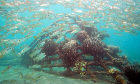
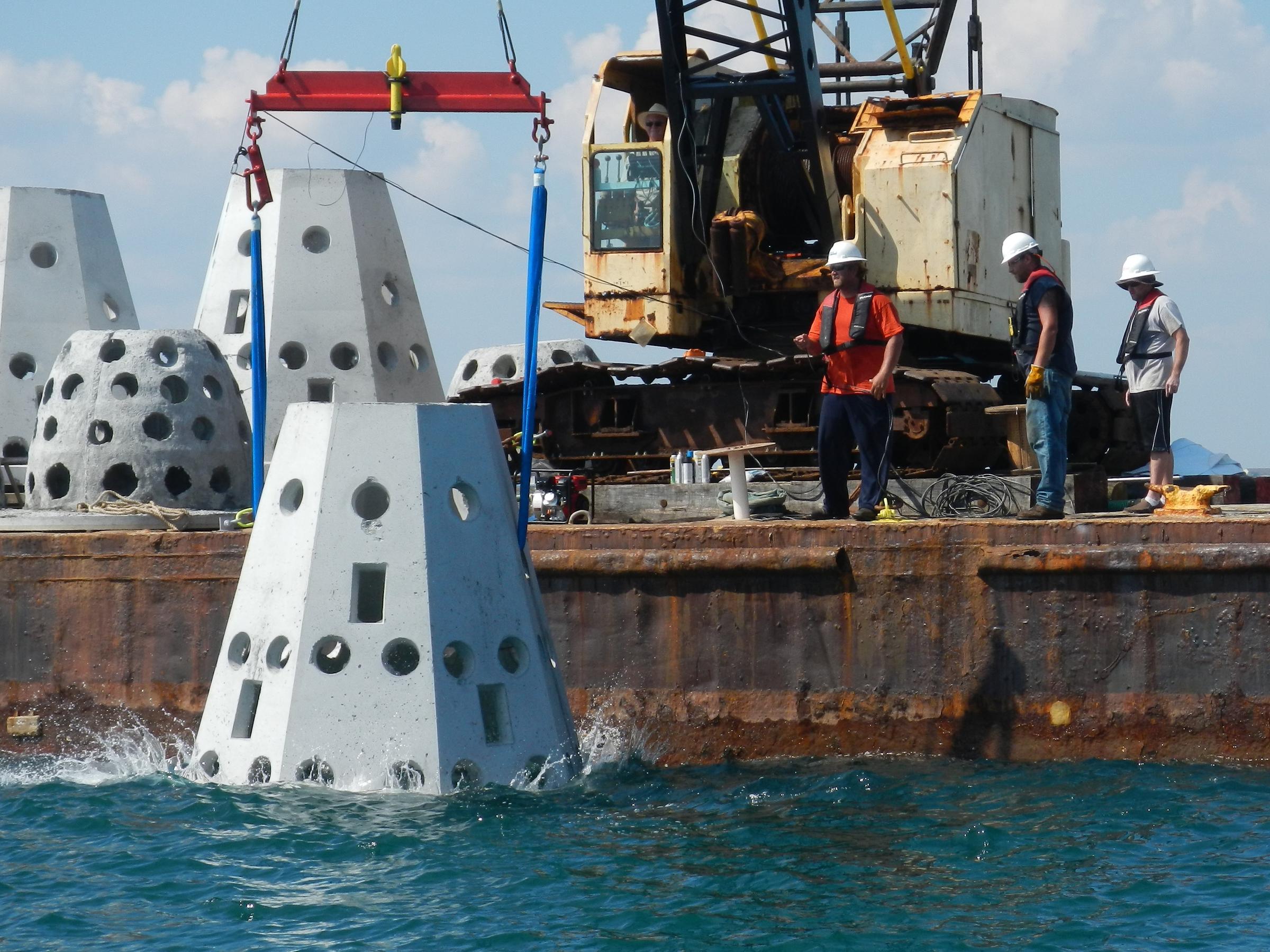
Two local firms will share $2.2 million in NRDA money to build the reefs. Walter Marine of Orange Beach will get $1.7 million to provide 77 large tetrahedron, or triangular pyramid, reefs, and about 300 smaller reefs. Coastal Reef Builders of Pensacola will use $531,000 to build 350 large dome reefs.

“We’re ready to go,” Robinson says. “We’re ready to get them working and hopefully there will be great opportunities for us to expand our fishing and for people to get out on the Gulf.”

Robert Turpin, Director of Marine Resources for Escambia County.
CREDIT ESCAMBIA COUNTY

“The end of the contract is June of 2019; however, it’s very likely that the construction will be completed well before that cutoff date,” said Robert Turpin, Escambia County’s Marine Resources Director. He says the structures will help increase fish populations using 21st century materials and deployment techniques.

“Cured concrete that is stable and durable,” said Turpin. “Some of this has limestone that is actually embedded into the concrete, which provides for a more natural sub-strait for attaching and boring organisms.”

As part of the project, there also will be an upgraded interactive map of area reef sites showing both reef modules and shipwreck sites through Google Earth; and a new app for GPS units.

“We also have the coordinates in a GPX format that is available for most of the newer GPS units,” said Turpin. “Where you can simply upload the coordinates in your GPS unit, instead of the old-fashioned way where you had to literally punch in the numbers one at a time.”

Meanwhile, construction is underway at the new Three Mile Bridge site, including plans for lead contractor Skanska USA to take down the old span. Turpin is hoping that those materials can be used to improve the reefs made from the remnants of the I-10 Bridge that was replaced after being destroyed by Hurricane Ivan.

“Skanska was one of the contractors that replaced the I-10 Bridge,” Turpin said. “So they know reefing of those materials is fast. And we’ve made it even faster, more efficient, therefore cheaper for them to do the same thing with the Three Mile Bridge rubble.”

As mentioned, Santa Rosa County is also building its reef program. According to the Pensacola News Journal, the county has about $1.2 million in the bank for additional modules at a snorkel reef off Navarre.

 This story originally aired on February 21, 2018. For more habitat articles go to Fishiding.com

What Exactly Is Fish Habitat and Why Must We Care?

Forward Post: AFS Journal
What Exactly Is Fish Habitat and Why Must We Care?
Mon Jun 3, 2013 2:29pm
What Exactly Is Fish Habitat and Why Must We Care?Thomas E. Bigford
Office of Habitat Conservation, NOAA/National Marine Fisheries Service, Silver Spring, MD 20910.
E-mail: Thomas.bigford@noaa.gov

“Fish habitat” is a
simple term. We can easily
imagine a fish languishing
under a log or in
a kelp forest, and we can
picture a school of forage
fish zipping through the
water column. We can
also grasp that the preferred
space for many species might change as the seasons change and
the years pass by. But the rest of the story is not quite so simple,
mostly because life is more complicated and knowledge is often
limited. This month’s “Fish Habitat Connections” seeks to demystify
those details so we can appreciate the intricacies in the
fish habitat world and become more emboldened to serve fish
not just as a meal but as they deserve.
Let’s begin with semantics. Each fish occupies its preferred
niche in the ecosystem. The environmental conditions of that
space define the fish’s preference at each life stage—water
temperature, depth, salinity, flow, bottom type, prey availability                                                annual cycles, and much more. It is important for us
as professionals to place those variables in proper context so
that individual fish can survive, fish stocks can flourish, fishery
management can succeed, and society can benefit from our nation’s
waters.
That simplistic summary reflects our hopes, which are
complicated by the reality that we know very little about our
most basic habitat questions. With luck, we know where fish
live throughout their life cycles. But oft times we have few
insights into the shifting preferences of each life stage. Even
that knowledge is elusive unless we have close observations
from multidecadal stock assessments or the insights offered
by a healthy fishery. Almost universally, we rarely understand
the relationships between fish and their habitat.

If a wetland is
dredged, how will the local fish populations change over the
short and long term? If a dam is breached, will the new hydrological
regime support native species or invite invasive species?
If an acre is protected or restored, how will the population respond?
Will harvests increase?
These issues read like the final program at many an American
Fisheries Society (AFS) conference. They have vexed us
as a profession for decades. We must manage fisheries with the
best available information, scant as it might be. And we must
identify our primary needs so that gaps are addressed.
COLUMN
Fish Habitat Connections There is also the still-new concept of ecosystem-based approaches.
Habitat must be an essential variable in stock assessments,
but those analyses must be conducted with an ecosystem
in mind. Those perspectives can be as important as data. Without
that challenge, we won’t even know we have a data gap.
Considering how complex this simple topic can be, and
how it reflects human pressures from our coasts to the mountains,
it is probably no surprise that we continue to lose habitat
function at alarming rates. Along our oceans, marine and estuarine
wetland loss was three times higher between 2004 and
2009 than in the previous 5 years (Stedman and Dahl 2008;
Dahl 2011). Inland wetland loss is not as severe, but hundreds of
rivers representing thousands of river miles are compromised by
blockages that prevent fish movement upstream or downstream.
The first-ever national fish habitat assessment found that 53%
of our estuaries are at high or very high risk of habitat degradation
(National Fish Habitat Board 2010). Given those numbers,
it is unfortunate that those places provide vital nursery habitats
for many of our favorite fish.
As fishery professionals from all disciplines, our assignment
is to combine our skills to protect important habitats and
restore those that are degraded. Our mission will be slightly
less daunting if we and our partners can set a pace to match
the steady pressure of human population growth and looming
challenges such as climate change. AFS represents an incredible
knowledge base. If anyone can analyze our habitat knowledge,
fill our priority gaps, apply lessons learned, and improve habitats
for the benefit of all, it is us.

More habitat articles at fishiding.com
Next month we will shift from the nuances of semantics
to the harsh realities of the challenge before us. It is imperative
that we engage now! Economic and ecological facts urge AFS,
its units, each of us, and our home institutions to accept the challenge.
We will explain the opportunities before us and how our
collective skills are needed for success.
REFERENCES
Dahl, T.E. 2011. Status and trends of wetlands in the conterminous
United States 2004-2009. U.S. Department of the Interior, Fish
and Wildlife Service, Washington, D.C. 108 pp.
National Fish Habitat Board. 2010. Through a fish’s eye: the status of
fish habitats in the United States 2010. Association of Fish and
Wildlife Agencies, Washington, D.C. 68 pp.
Stedman, S., and T. E. Dahl. 2008. Status and trends of wetlands in the
coastal watersheds of the Eastern United States 1998 to 2004. National
Oceanic and Atmospheric Administration, National Marine
Fisheries Service, and U.S. Department of the Interior, Fish and
Wildlife Service, Washington, D.C. 32 pp.

Biorock giving new life to coral reefs

Johnny Langenheim explains how an innovative method is sustaining corals and why on World Oceans Day we need to pledge for more such projects

Coral reef restoration Biorock project at Ibu Karang, Pemuteran, Bali, Indonesia

Biorock project at Ibu Karang, Pemuteran, Bali, Indonesia. Photograph: T.Goreau/Biorock

Coral reefs are the rainforests of the world’s oceans. Like their terrestrial counterparts, they occur in tropical and sub tropical environments, support a bewildering variety of species and are diminishing at an alarming rate. See the dozens of unique artificial fish habitat models, fish attractors and fish cover used at fishiding.com, the leader in proven science based, fish protection.

Marine biologists across the world are desperately trying to protect our remaining reefs from the impacts of global warming and destructive fishing. Others are building repositories of the known coral species – so that our grandchildren at least get to see them in aquariums or laboratories – and still others are constructing artificial reefs in areas of significant damage.

Humans have been creating reefs for thousands of years to improve their fisheries – you can pretty much sink anything solid in the right marine environment and calcium carbonate, the key ingredient in coral, will accrete to it. It’s a hit and miss affair, though, often bringing just a fraction of the biodiversity seen in a natural reef. But in the 1970s, some simple science created dramatic changes.

The biorock method was developed by architect and marine scientist Wolf Hilbertz and marine biologist Tom Goreau. They found that by running a small electrical current through seawater, a hard shell of calcium carbonate would form on the cathode. You could then attach small pieces of natural coral to the structure. The corals seemed to love these substrates, achieving growth rates often five times faster than normal. Today there are more than 20 Biorock projects around the globe, but by far the biggest – and arguably the most innovative – are in Indonesia.

“Right now we have 62 biorock structures around this island,” says Delphine Robbe, as she pulls on a wetsuit. “By 2012 we should have one hundred.”. Since coming to Gili Trawangan in 2005 with a vague plan to get her dive master certification, the Frenchwoman has become the driving force behind the island’s many eco programmes.

Trawangan is one of three tiny coral atolls off the coast of Lombok, Indonesia and increasingly a compulsory side trip to any Bali holiday, thanks to its bone white beaches, diving and snorkelling sites and absence of both dogs and motor vehicles. Pristine reef, however, is harder to find. “Probably 70 to 80% of our shallow reefs were destroyed by dynamite fishing,” Robbe tells me. “It was actually the local fishermen who kick started the eco movement here, when they set up patrols to try and stop the bombing.”

Goreau’s attention is on the Gili cluster, which has impressed him with its biodiversity and water quality. He and Hilbertz had chosen the tiny village of Pemuteran in north Bali as the site of what is today the largest biorock project in the world and are now looking for new areas to colonise with their artificial reef structures. Robbe met Goreau at the first Biorock conference and workshop in Trawangan in November 2005 and by the end of it, she’d been enlisted. “The next year, I led the workshop and brought in the major dive operators as sponsors,” she explains. “In return, they got their very own biorock installations in front of their dive shops.”

Besides stimulating biodiversity, the biorock structures also combat beach erosion, which became a serious problem with the destruction of the natural reefs. Increasingly, they are an attraction for tourists too – especially since English artist and environmentalist Celia Gregory joined the project.

Gregory, who besides being a mosaic artist and sculptor is also a dive master, contacted Tom Goreau after seeing the biorock project in Pemuteran. “I was really inspired by what they’d done and it gave me this idea of merging art with coral conservation,” she explains. “Plus I’d experienced dynamite fishing first hand when a device went off during a dive. We saw the shattered coral and the dead fish.”

Divers and snorkellers can now see underwater scultpures of a manta ray, dolphin, turtle, octopus, snake, moon, miniature phinisi schooner and even a komodo dragon. Gregory is now working with award winning industrial designer Tom Dixon who wants to create an underwater three-piece suite, while Bali based US photographer and vintage motorbike enthusiast Dustin Humphrey is thinking of sinking some old bikes and doing an underwater shoot complete with models.

Meanwhile, Robbe is building on the eco credentials of the project by exploring alternative sources of energy with which to power the biorock installations. “Running cable out to see and powering it with diesel generators is not exactly sustainable,” she says. “So we’re planning to build our first tidal energy turbines this year and then unroll much bigger ones by November 2012, the date of our next workshop.” She’s also landed some major commercial sponsors – oil company Total is looking to help fund the turbines, while Malaysian Airlines wants to put in an airplane sculpture.

But all of this comes with a caveat. The increasing popularity of the Gilis has prompted an unprecedented surge in development that threatens to scupper conservation efforts in the long term. Rising population and a rash of new construction is putting pressure on an island whose circumference is just 12km and which imports nearly everything, including fresh water.

Behind the quaint beach facing facades of the hotels, lies an open dump where most of the island’s rubbish goes, though Robbe recently set up a recycling system with the help of a Bali based company. The hotels often have rudimentary wastewater treatment systems, so biological waste goes straight into the sea, where it may create algae blooms that are toxic to coral.

There are a few exceptions. I stayed at the largely wind- and solar-powered Gili Eco Villas on the quiet north side of the island. They even have their own biorock sculpture of a whale.

“I have this vision of Gili Trawangan being a model of sustainability – it’s like a microcosm of the rest of the world, experiencing both threats and opportunities” Gregory says. “It has these amazing currents, endless sunlight and it’s small and contained enough to manage – if we were just smart about it.”

Gulf rigs, structures on track to become Essential Fish Habitat

Gulf Council begins process to properly recognize value of artificial reefs

CORPUS CHRISTI, TX – A request to have the Gulf of Mexico Fishery Management Council begin the process of classifying rigs and other vital artificial reefs as Essential Fish Habitat (EFH) was unanimously approved by the Council at its April meeting in Corpus Christi, Texas. Dr. Bob Shipp, Council member from Alabama and chairman of the Department of Marine Sciences at the University of South Alabama, made the motion as part of an effort to protect those structures from a 2010 federal directive to summarily remove all non-producing energy structures within five years of the issuance of that directive.

“This action sets in motion an amendment process that could be huge in the battle to save these structures, many of which are covered in tons of living coral and form the basis of thriving ecosystems,” said Pat Murray, CCA president. “We greatly appreciate Dr. Shipp for bringing this important issue to the Gulf Council to emphasize how important these structures are to the marine environment, and to anglers and divers.” See the dozens of unique artificial fish habitat models, fish attractors and fish cover used at fishiding.com, the leader in proven science based, fish protection.

If artificial reefs are eventually designated as EFH, all federal agencies would then have to consult with NOAA Fisheries on federal actions that may adversely affect them. The number of required consultations could be considerable given the current rate of platform removals and installations and, despite these consultations, NOAA Fisheries could only make non-binding recommendations as to how to conserve the affected habitat.

“This is a significant part of the effort to elevate the importance of artificial reefs and save them from an ill-conceived federal order, but we have to continue to work this issue in Congress and with the Administration,” said Murray. “With the offshore season upon us, the realization of the impact of rig removal is only going to become more acute as anglers go offshore and discover that rigs they have fished for years are gone.”

In a misdirected response to the Gulf oil spill, the U.S. Department of Interior issued a directive in October of 2010 ordering that all non-producing rigs be plugged and any remaining structure removed. There are approximately 3,500 offshore structures in the Gulf of Mexico and the directive, known as the Idle Iron Policy, would immediately impact roughly 650 structures that have not produced oil or gas within five years of the directive issue date of Oct. 15, 2010.

Sen. David Vitter (R-La) and Rep. Steve Palazzo (R-Ms) have filed legislation that would prevent rigs and other structures from being summarily removed from the Gulf of Mexico, but both bills face a difficult road through the current Congress. NOAA Fisheries declaring artificial structures and rigs as Essential Fish Habitat is a significant addition to those legislative efforts.

Grant Funding for Habitat Restoration Projects

Grant Funding is Available for Community-based Habitat Restoration Projects

The FishAmerica Foundation, the conservation and research foundation of the American Sportfishing Association, has funds available for marine and anadromous sportfish habitat restoration projects throughout coastal America, the Great Lakes region, and all U.S. Territories through its partnership with the National Oceanic and Atmospheric Administration’s (NOAA) Restoration Center.

See the dozens of unique artificial fish habitat models, fish attractors and fish cover used at fishiding.com, the leader in proven science based, fish protection.

Artifical Products grow fish

First Coast may need to help bolster key industry – fishing

 First Coast anglers see fishing spots disappearing so quickly they say it’s time to create new fishing grounds to bolster an industry that the state says brings half a billion dollars into the local economy every year.
Scott Shine, a member of the Jacksonville Waterways Commission, said he is looking into ways to add more access to fishing in North Florida before the economic impact does permanent damage to the recreational fishing industry.
A Waterways Commission subcommittee has been formed to examine adding artificial reefs just offshore and in the St. Johns River.
See the dozens of unique artificial fish habitat models, fish attractors and fish cover used at fishiding.com, the leader in proven science based, fish protection.
The federal government has closed several offshore fishing spots in recent years because of depleted fish stocks. There are also large tracts of water that have been placed off limits to vessels around military installations for security reasons.
“While we grow and while we’re seeking opportunities for tourism, we’re not growing our access to waterways on the same level that we’re experiencing in the growth in population,” Shine said.
RestrictionsThe recent restrictions cover hundreds of miles of ocean off the Southeast coast of the United States. Along the First Coast, those restrictions are hampering an industry that generates about $556 million a year for Northeast Florida, according to a report Shine drafted in January based on a 2010 Florida Fish and Wildlife Conservation analysis.
Shine based his figures on the North Florida share of fishing licenses sold in the state along with other factors, such as fishing industry tracking data the state agency used to develop estimates.
Recent federal regulations restricting offshore catches of grouper, red snapper and other fish are already beginning to take their toll on the area recreational fishing industry.
“We’ve been losing ground,” said Vic Tison, who runs a charter boat fishing service and is chairman of the North Florida Chapter of the Recreational Fishing Alliance. “We’re getting less and less areas to fish. Where’s that going to leave us?”
Adding to the frustration for anglers is a restricted zone instituted around Mayport Naval Station last year.
With little public notice, the U.S. Army Corps of Engineers added a 380-foot no-vessel zone on a 2½-mile stretch of water surrounding the base.
Tison said it has already blocked many of his charter excursions that used to sail near the base.
Roy Crabtree, the Southeast regional administrator for National Oceanic and Atmospheric Administration Fisheries, said the agency takes into account the economic impact when implementing restrictions. In addition, Crabtree said recreational and commercial fishing interests were represented on the panel that made the decisions.
SolutionsWhile Shine concedes there is little sports anglers can do about the restrictions, he thinks the problem can be mitigated by creating new areas for fishing.
He said creating artificial reefs within 3 miles of shore would put those waters under state jurisdiction, cutting the federal government out of the equation. In addition, Shine wants artificial reefs to be sunk in the St. Johns River near the Mill Cove area in order to offset the restricted zones around the Mayport base and Blount Island.
“It increases access to fishing opportunities,” Shine said. “The federal government is drawing boxes on a map that are shutting down fishing and access in those areas.”
Crabtree said Shine’s proposal could provide some increased access in the face of the federal restrictions.
“If they were to put artificial reefs in state waters over there, that may provide access in fishing for anglers of a variety of species,” he said.
Tison acknowledged Shine’s proposals could keep the recreational fishing economy stable.
“It’s very important,” he said. “We’re getting less and less areas to fish continually. … Anytime you put a rock down or a structure down in the water, it’s going to create fishing habitat, and that gives the anglers more areas to fish.”

By Matt Dixon 
Morris News Service

Pier’s success provided by artificial reefs for fish

Transition from old Twin Spans to Slidell Fishing Pier almost done

Slidell, LA —  St. Tammany leaders are now targeting late April for the opening of the Slidell Fishing Pier.  The wooden bridge leading to the old Twin Span bridge is done, and the early reviews are good.

“I think it came out a lot better than I expected even,” St. Tammany Parish Councilman Richie Artigue said.  Artigue predicted the pier will get a lot of use once it opens.See the dozens of unique artificial fish habitat models, fish attractors and fish cover used at fishiding.com, the leader in  science based, proven, fish protection.

It was originally conceived by former Parish President Kevin Davis, as a way to use part of the old bridge as a Pensacola-style fishing pier.  The wooden bridge includes two gazebos.

“This is going to be one of the best things parish government ever did for the people of the parish, Councilman Artigue added.  “We’ve got many, many people who don’t have boats, can’t go out fishing.  This is going to be the place for people to bring their families, bring their kids, and come out here and catch a fish.”

The delay comes because it took longer than expected to run utilities, water, sewage and electricity.

“If anything,” St. Tammany Parish Spokesperson Suzanne Parsons-Stymiest said, “the last couple of months, when we had to postpone the opening from the original date, has really enforced for us how much the public wants this.”

Eventually, the fishing pier will include 24-hour security and lighting.  To pay for those services, people fishing should expect to pay a fee, perhaps in the neighborhood of $5, according to parish leaders.

“We want it to be clean, we want it to be lit, we want security,” Suzanne Parsons-Stymiest added.  “We want the availability of amenities such as a bait shop, so that fee is going to be put directly back into the operation of the fishing pier.”

All of that, as well as a bait shop and a restaurant will be in place “eventually” parish leaders said Monday, although perhaps not on opening day.

Louisiana Wildlife and Fisheries agents dropped hunks of concrete into Lake Pontchartrain near the pier, to create artificial reefs for fish.  And that’s the bottom line for why parish leaders believe the pier will be successful, because fishing experts say, fish will be plentiful under the pier.Doug Mouton / Northshore Bureau Chief
Email: dmouton@wwltv.com | Twitter: @dmoutonwwl

Space ships for fish habitat

Florida Today reports that Cape Canaveral officials are seeking federal approval to add more material — including segments of NASA and military rocket launch towers — to an existing 4-square-mile area called the Brevard County Artificial Reef Site 2.

Brevard plans to add parts of bridges, vessels, boulders and other materials to the existing artificial reef.County officials also hope to add portions of old defunct launch complexes from Cape Canaveral Air Force Station and Kennedy Space Center. That could help the military and NASA defray costs of disposing of old launch complex material. “Instead, they can invest in a local project,” Culver said.

“We would want the structural beams, the large tower-type materials that they have out there,” Culver said. “There may be more than we can actually use.”

See the dozens of unique artificial fish habitat models, fish attractors and fish cover used at fishiding.com, the leader in  science based, proven, fish protection.

The launch pad materials would first have to be inspected for anything hazardous. No fiberglass, fuel lines, toxic paints or asbestos would be allowed.

Past reef efforts include four giant liquid storage tanks used on the Titan missile program — the so-called Titan Reef — sunk in the fall of 1994 in conjunction with the U.S. Air Force. In July 1989, the Air Force donated materials from obsolete launch pads for another artificial reef.

No specific towers are identified in the Defense Department permit application.

Residents fear shoreline project will smother reef

Structures a home for sea creatures

Three acres of coquina and worm rock could be covered by a beach renourishment project.
Three acres of coquina and worm rock could be covered by a beach renourishment project. / Photos courtesy of Karen Holloway-Adkins

A new beach renourishment project is in the works for Brevard County, and conservation-minded residents are worried that trucking in the sand will bury a local treasure.

The Brevard County Mid Reach Shore Protection Project aims to dump 573,000 cubic yards of sand onto the 7.8-mile section of beach between Patrick Air Force Base and Indialantic. By adding up to 20 feet of beach, three acres of coquina and worm rock reef will be smothered.

But marine biologist Karen Holloway-Adkins knows the reef is more than just a pile of rocks.

See the dozens of unique artificial fish habitat models, fish attractors and fish cover used at fishiding.com, the leader in  science based, proven, fish protection.

“Worm rock doesn’t get much credit. A lot of people don’t even know what’s out there.” said Holloway-Adkins. “It’s a full-on living reef.”

The large, cauliflower-shaped boulders are not rocks, but the protective sand structures secreted by colonies of bristle worms of the family Sabellariidae (pronounced “SAH—bell—AIR– I—dee”).

But the worms are just a small piece of the reefs’ complexity.

“The algae growing on the reef provides food for turtles and fish.

“The structure is excellent habitat for crabs, blennies, sheepshead, snook, pompano and more,” said Holloway-Adkins, who lives in Indialantic. “I’ve even seen an octopus under one of the ledges.”

Holloway helps run a nonprofit research company, East Coast Biologists, Inc., and was hired by the County to aid in an Environmental Impact Assessment for the project.

Her work revolves specifically around the green sea turtles which feed almost exclusively on the red, green and brown algae growing on the reef. She’s logged countless hours snorkeling the reefs in the Mid Reach zone — when the underwater visibility permits it.

“The juvenile greens will forage and hang around the intertidal zone, sometimes in less than two feet of water.”

The high-energy intertidal zone — the area dappled with small tide pools near shore — is threatened most by the filling project.

“Those pools are important for gamefish,” Holloway-Adkins said. “That’s where you’ll see schools of baby pompano. It’s an important nursery.”

The threat to gamefish and the local ecology has Space Coast fishing authority, Captain Rodney Smith, reeling with concern.

“It’s an extremely unique habitat because this reef is also part of the Indian River Lagoon estuary,” said Smith, a fishing guide for over 20 years and founder of Coastal Angler Magazine. “It’s all connected ecologically. It’s such a treasure.”

Smith conducts guided surf-fishing clinics and recognizes the significance of the reefs for the recreational fishery. As one who makes his living from the area’s natural splendor, he empathizes with business and home owners who are faced with protecting their assets on the beach.

“Change is definitely difficult,” Smith said. “But the quality of life drops during these projects, the beach as we love it is destroyed and the degradation to the habitat is profound.”

As far as the economics of the fill, Smith would like to see changes in how these projects are carried out. With Florida’s dynamic coastline of shifting sand dunes, replenished beaches can be stripped away by hurricanes and strong storms.

“Millions of taxpayer’s dollars are swept into the ocean in a day,” Smith said.

“It’s like throwing sand into a volcano. We need to reassess how we’re managing our beaches.”

Smith’s wish may somewhat come true.

Mike McGarry, the Beach Project Coordinator for Brevard, says that the Mid Reach project is a one-of-a-kind operation designed by the Army Core of Engineers.

“The Mid Reach project is vastly different from a typical beach renourishment. We’ve made sure a large weight has been placed on the environmental consequences.”

Sand will be harvested offshore, stockpiled in Port Canaveral and placed on the beach by dump truck. There won’t be any rusty pipes snaking through the sand from offshore pumping barges, as in previous filling ventures.

“Less than 10 percent of the rocks in the Mid Reach zone will be covered, allowing 90 percent of the habitat to remain,” McGarry said.

“We don’t discount that there won’t be an impact to the environment, but we’ve taken all the steps possible to minimize that impact.”

To mitigate for any damage to the reef that can’t be avoided, the county and the ACOE have devised an artificial reef system that will be placed in parts of the Mid Reach stretch.

Coquina rocks embedded in concrete-block grids will be laid by crane in 12-15 feet of water — after the fill is completed.

The reef habitat in the Mid Reach zone has been designated as an “Essential Fish Habitat” by the National Marine Fisheries Service, which requires the involved parties to take precautions to ensure the health of the ecosystem, including the design of these ‘mitigation reefs’.

But they’re still not the real, living thing.

And although keeping the surf-side infrastructure intact is vital to the area’s economy, Rodney Smith feels that healthy reefs are a part of our culture that can’t be bought.

“You can’t destroy a natural reef and then try to fix it,” Smith said. “They’re priceless.”

Written by
Matt Badolato
For FLORIDA TODAY

The Radford Becomes a Reef Creating fish habitat

What was once a 553-foot Navy destroyer has become the East Coast’s largest artificial reef. This summer, as tourism and natural resources officials from Delaware, New Jersey and Maryland looked on, the new “reef,” slowly sunk to the bottom of the Atlantic Ocean. The Del-Jersey- Land reef, (named for the three states involved in the project) took about four hours to make its 138-foot descent.

The USS Arthur W. Radford’s final resting place is roughly 28 miles northeast of the Ocean City inlet, midway between the Indian River and Cape May. The Del-Jersey-Land reef is a cooperative venture between the three states to enhance fisheries habitat through decommissioned and retired ships, and railway and subway cars. See the dozens of unique artificial fish habitat models, fish attractors and fish cover used at fishiding.com, the leader in  science based, proven, fish protection.

“It’s going to be a huge economic boost for Ocean City,” says Erik Zlokovitz, the artificial reef coordinator for DNR. “It is expected to attract bluefish, sea bass, weakfish, sharks and tuna, and that will attract charter fleets.”

The Radford was commissioned in 1977 and held a crew of more than 300. It patrolled Venezuela, Panama, Argentina, Brazil, Senegal, Oman, Bahrain, the Azores, Nova Scotia, Italy and Turkey. One of its final missions was deployment during Operation Enduring Freedom. The Radford’s homeport was Norfolk, Va.

The ship was named for Admiral Arthur Radford who served in three wars. He was onboard the USS South Carolina during World War I, in the Office of the Chief of Naval Operations during World War II and was Commander in Chief of the U.S. Pacific Fleet at the outbreak of Korean hostilities.

Taking nearly four hours to sink, the USS Radford is the largest ship to become a reef.

Jill Zarend-Kubatko is the Publication Manager in DNR’s Office of Communication.

Scroll to Top