StructureSpot

Oklahoma wildlife officials hope fish like tornado debris

  • Oklahoma Debris Spider Block.jpg

    Debris from the recent tornado that swept through Oklahoma is being put to use by state conservation officials, who are submerging it in lakes to form “fish attractors.” (wildlifedepartment.com)

Debris from the recent tornado that swept through Oklahoma is already being put to use by state conservation officials, who are submerging it in lakes to form “fish attractors.”

Cinder blocks scattered by the twister that killed 24 last month have been collected by the Oklahoma Department of Wildlife Conservation, which will use them to make what anglers call “spider blocks,” to sink in state lakes, according to The Oklahoman

“We’ve probably got close to 500 right now,” Greg Summers, of the Oklahoma Department of Wildlife Conservation, told the newspaper. More habitat articles at fishiding.com

Fish congregate around the spider blocks, which get their name from the appearance given by the PVC pipe that sticks out from the cinder blocks.

“Predators use them as an ambush point,” Summers said. “That’s why they are valued as fish attractors because they do attract predators.”

Spider blocks are usually placed at depths of 12 feet or less, and marked for anglers.

Read more: http://www.foxnews.com/science/2013/06/04/oklahoma-wildlife-officials-hope-fish-like-tornado-debris/#ixzz2W0JRnrJw

TPWD stocks stripers at PK Lake


Texas Parks and Wildlife Department biologist Wes Studder aids in transferring a net full of the more than 100,000 striper fingerlings stocked at Possum Kingdom Lake May 30. The stocking was done following a work project which sank cedars and brush piles to increase fish habitat in the lake. (Sarah Howard)

In an effort to continue to increase the fish population at Possum Kingdom Lake, Texas Parks and Wildlife Department stocked 100,000 striper fingerlings May 30. The fish arrived from the new TPWD East Texas fish hatchery in Jasper. They were then transported by boat from North D&D to deeper water before being released into the lake. “We use the deep water transfer to help avoid predators that are usually close to the shoreline,” said Steven Hise, TPWD staff member charged with the job of transferring the fish. According to Wes Studder, TPWD senior technician, the stocking was done following a work project which sank cedars and brush piles to increase fish habitat in the lake. “The new brush piles will provide shelter for the new fish,” he said. “It is great to have a group of people to work with on projects like this.” TPWD is working in conjunction with Hell’s Gate Bass Club on projects to improve the lake. Plans to coordinate with the club were made after an April HGBC meeting where members voted to establish a chapter of Friends of Reservoirs. The program will enable the club to obtain grants and donations for projects done in conjunction with TPWD. TWPD also plans to start 60 small colonies of American pond weed and water willow in the Cedar Creek area of the lake. “We have plans to return to the lake in June to establish vegetation habitats,” said Studder. “It will give us another chance to work with the Hell’s Gate Bass Club.” Dropping water levels and the age of the reservoir have resulted in fewer habitats and less natural plant growth that acts as a refuge for younger fish. To battle this, TPWD began a habitat enhancement project. Its goal is to create natural and artificial habitats, as well as re-introduce aquatic vegetation into the lake creating safe places for young fish. By Sarah Howard. More habitat articles at fishiding.com

At work on the North Fork

AGFC projects under way on riverbed, overlook

North Fork River projects
North Fork River projects: Overlook and fish habitat improvement underway

Written by
FRANK WALLIS
Mike Cantrell, Arkansas Game and Fish Commission coordinator of Regional Maintenance, points to the North Fork River while standing on an overlook now under construction on a bluff above the river. The new overlook is near the city of Norfork.More habitat articles at fishiding.com

Mike Cantrell, Arkansas Game and Fish Commission coordinator of Regional Maintenance, points to the North Fork River while standing on an overlook now under construction on a bluff above the river. The new overlook is near the city of Norfork. / Kevin Pieper/The Baxter Bulletin

watch it online

See a related video
on the North Fork River projects online atwww.baxterbulletin.com.

NORFORK — The North Fork of the White River and the scenic valley that cradles it are expected to offer some new accommodations for fish and humans by the summer’s end.

An award-winning team of biologists is set to begin work in the riverbed, strategically placing a series of boulders and root wads in the stream for fish habitat and bank stabilization.

Meanwhile, an Arkansas Game and Fish Commission construction crew is building a new scenic overlook on the east side of AR Highway 5 to the north of Norfork.

Fish habitat

AGFC Biologist Tim Burnley told The Bulletin the river work is a second phase of the North Fork River Habitat Project that began in January 2012.

The work involves about 1.5 miles of riverbed and riverbanks from the head of Cooper’s Island downstream to waters fronting River Ridge Inn. Burnley said the stretch of river below Cooper’s Island — known to anglers and biologists as The Flats — hasn’t contained many objects to create holding places for fish, also known as “lunker bunkers.”

“We plan to come in with in-stream cover — mostly rocks and rootwads,” Burnley said. “With that and new water from minimum flow, we expect to have some good fishing in this area of the river.”

Burnley heads up the $100,000 project with AGFC biologists Tony Crouch and Eli Powers.

A series of large boulders is planned for placement at the head of Cooper Island to offer some floodwater protection for the natural island structure and, at the same time, create new holding places for fish.

A similar series of boulders was placed on Charlie’s Island in the first phase of the project.

Overlook project

Mike Cantrell, coordinator of AGFC’s Calico Rock Regional Maintenance, leads an AGFC team in construction of a new public overlook on the east side of Highway 5 just north of its intersection of AR Highway 341.

Cantrell said the overlook will offer a much broader view of the river valley than can been seen from an unmarked pull-off to the north of the new overlook site.

A platform is planned for sightseers with disabilities.

A second viewing site higher on the ridge is planned for hikers. Parking for up to eight passenger cars or trucks is planned, but not for buses due to a relatively steep grade to the parking area, Cantrell said.

The material cost for the overlook is about $27,000, Cantrell said.

Both projects are funded mostly through the U.S. Fish and Wildlife Service’s Sport Fish Restoration Fund administered by AGFC. That fund matches $3-to-$1 a contribution of $25,000 for the fish habitat project from the the state’s Overlook Estates Settlement Fund held jointly by the Arkansas Department of Environmental Quality and Trout Unlimited.

Award-winning work

Burnley‘s group and an array of contributors including the U.S. Fish and Wildlife Service, Explorer Scouts, Trout Unlimited, the U.S. Army Corps of Engineers and the Friends of the North Fork Fish Hatchery, are 2010 recipients of the American Fisheries Society’s Sport Fish Restoration Project of the Year Award.

The project included substantial stream-bed and bank stabilization for Dry Run Creek with major access for anglers with disabilities.

What Exactly Is Fish Habitat and Why Must We Care?

Forward Post: AFS Journal
What Exactly Is Fish Habitat and Why Must We Care?
Mon Jun 3, 2013 2:29pm
What Exactly Is Fish Habitat and Why Must We Care?Thomas E. Bigford
Office of Habitat Conservation, NOAA/National Marine Fisheries Service, Silver Spring, MD 20910.
E-mail: Thomas.bigford@noaa.gov

“Fish habitat” is a
simple term. We can easily
imagine a fish languishing
under a log or in
a kelp forest, and we can
picture a school of forage
fish zipping through the
water column. We can
also grasp that the preferred
space for many species might change as the seasons change and
the years pass by. But the rest of the story is not quite so simple,
mostly because life is more complicated and knowledge is often
limited. This month’s “Fish Habitat Connections” seeks to demystify
those details so we can appreciate the intricacies in the
fish habitat world and become more emboldened to serve fish
not just as a meal but as they deserve.
Let’s begin with semantics. Each fish occupies its preferred
niche in the ecosystem. The environmental conditions of that
space define the fish’s preference at each life stage—water
temperature, depth, salinity, flow, bottom type, prey availability                                                annual cycles, and much more. It is important for us
as professionals to place those variables in proper context so
that individual fish can survive, fish stocks can flourish, fishery
management can succeed, and society can benefit from our nation’s
waters.
That simplistic summary reflects our hopes, which are
complicated by the reality that we know very little about our
most basic habitat questions. With luck, we know where fish
live throughout their life cycles. But oft times we have few
insights into the shifting preferences of each life stage. Even
that knowledge is elusive unless we have close observations
from multidecadal stock assessments or the insights offered
by a healthy fishery. Almost universally, we rarely understand
the relationships between fish and their habitat.

If a wetland is
dredged, how will the local fish populations change over the
short and long term? If a dam is breached, will the new hydrological
regime support native species or invite invasive species?
If an acre is protected or restored, how will the population respond?
Will harvests increase?
These issues read like the final program at many an American
Fisheries Society (AFS) conference. They have vexed us
as a profession for decades. We must manage fisheries with the
best available information, scant as it might be. And we must
identify our primary needs so that gaps are addressed.
COLUMN
Fish Habitat Connections There is also the still-new concept of ecosystem-based approaches.
Habitat must be an essential variable in stock assessments,
but those analyses must be conducted with an ecosystem
in mind. Those perspectives can be as important as data. Without
that challenge, we won’t even know we have a data gap.
Considering how complex this simple topic can be, and
how it reflects human pressures from our coasts to the mountains,
it is probably no surprise that we continue to lose habitat
function at alarming rates. Along our oceans, marine and estuarine
wetland loss was three times higher between 2004 and
2009 than in the previous 5 years (Stedman and Dahl 2008;
Dahl 2011). Inland wetland loss is not as severe, but hundreds of
rivers representing thousands of river miles are compromised by
blockages that prevent fish movement upstream or downstream.
The first-ever national fish habitat assessment found that 53%
of our estuaries are at high or very high risk of habitat degradation
(National Fish Habitat Board 2010). Given those numbers,
it is unfortunate that those places provide vital nursery habitats
for many of our favorite fish.
As fishery professionals from all disciplines, our assignment
is to combine our skills to protect important habitats and
restore those that are degraded. Our mission will be slightly
less daunting if we and our partners can set a pace to match
the steady pressure of human population growth and looming
challenges such as climate change. AFS represents an incredible
knowledge base. If anyone can analyze our habitat knowledge,
fill our priority gaps, apply lessons learned, and improve habitats
for the benefit of all, it is us.

More habitat articles at fishiding.com
Next month we will shift from the nuances of semantics
to the harsh realities of the challenge before us. It is imperative
that we engage now! Economic and ecological facts urge AFS,
its units, each of us, and our home institutions to accept the challenge.
We will explain the opportunities before us and how our
collective skills are needed for success.
REFERENCES
Dahl, T.E. 2011. Status and trends of wetlands in the conterminous
United States 2004-2009. U.S. Department of the Interior, Fish
and Wildlife Service, Washington, D.C. 108 pp.
National Fish Habitat Board. 2010. Through a fish’s eye: the status of
fish habitats in the United States 2010. Association of Fish and
Wildlife Agencies, Washington, D.C. 68 pp.
Stedman, S., and T. E. Dahl. 2008. Status and trends of wetlands in the
coastal watersheds of the Eastern United States 1998 to 2004. National
Oceanic and Atmospheric Administration, National Marine
Fisheries Service, and U.S. Department of the Interior, Fish and
Wildlife Service, Washington, D.C. 32 pp.

Hooked for life – by Bruce Kania

Hooked for life – by Bruce Kania

May 30, 2013
posted by Anne
IMG_0604Fish Fry Lake may be the best fishing hole in Montana…at least for kids!  The lake is only 6.5 acres, but the water’s invitingly clear and it is extremely easy to catch yellow perch, crappie and bluegills.  Even some Yellowstone Cutthroat trout happen here…which may be their easternmost extension.  Fish grow fast in this lake at Floating Island International’s headquarters 25 miles from Billings, Montana.  Fish Fry Lake is a test site for BioHaven® floating islands as well as other embodiments of BioHaven technology.Last year over forty kids (and a couple adults) caught their very first fish on the lake.  For most of these fisher people it was as simple as attaching a piece of nightcrawler onto a small jig head, then flipping the baited hook into the crystal clear water and watching their line for some indication of a bite.  Typically the line will twitch when a fish picks up the offering, and then it’s a straightforward process.  Lift the rod tip and reel in a scrappy panfish.  Some kids start off with a cane pole, just like I did way back when.  Today there’s even lighter fiberglass extension poles and it’s pretty easy for little guys, and gals, to swing the offering over open water, wait a moment, then pull up a seriously exciting fish!The pond is also home to painted turtles, leopard frogs, bullfrogs, tadpoles, blue herons, mallards, wood ducks, teal, spoonbill, widgeon, yellow and red headed blackbirds, woodpeckers, garter snakes, the occasional bull snake, crawfish, salamanders, Canada geese, osprey and even the occasional Bald Eagle, all of which tend to be of great interest to kids.  As I was growing up there was a similar wetland within walking distance…and kid tracks along the shoreline evidenced fascination with critters and plants, and pretty much everything wild.  Episodes with poison ivy notwithstanding, kids and water and fields and wildlife, they used to go together as naturally as water flows downhill.  Today though, computers seem to have taken over some of that space, some of the territory that used to be reserved for kids and nature to get to know each other. 

We are not against computers!  The advances associated with the huge strides in information transfer technology that we’ve experienced in the last twenty years are life changing, and mostly positive.  But wouldn’t it be ideal if we could retain some connection with nature?  And certainly not just on a computer screen, but in person and up close!  Catching a fish, splashing after a leopard frog, or sneaking up on a big old gander goose is the stuff of childhood, and I don’t think it’s a good thing to miss out on.

I remember a troupe of kids passing by with fishing rods in hand one day last summer, when one of the boys, lagging behind, complained about the sun being “too hot!”  A young gal in the group suggested he “man up”, at which point the young lad was pretty much forced by the amazing power of peer pressure to deal with conditions.  Not sure if those kind of life lessons happen frequently in front of a computer screen.

And kids don’t catch fish automatically.  Not even on Fish Fry.  They must learn the process, think it through, and then connect the dots.  Along the way, with a bit of patience, they are rewarded.  This is good stuff for kids.

There was a young gal that could not handle touching a worm.  When it came to touching a fish, that was at least as bad as the idea of touching a worm.  An hour later she was independently doing both.  Real life lessons, and a new connection with where food comes from.  More good stuff!

Today the majority of fresh water lakes in the U.S. are so nutrient rich that they are at risk of running out of dissolved oxygen, without which fish die.  Fish Fry Lake has turned this condition on its head.  We have learned how to cycle those same nutrients into fish, instead of algae.  Catch rate on Fish Fry is a fish every two minutes on average.  The 6.5 acre lake yielded 5,168 fish last year, which translates to 210 pounds of fish per acre.  And along the way the water in Fish Fry was kept within Cutthroat Trout temperature requirements.  A nearby public lake, with conventional management, yielded about ten pounds of fish per acre.  And those fish were stocked, while Fish Fry’s are wild and naturally reproductive.  In late summer, the bottom half of the public lake is devoid of breathable oxygen.  Trout that were stocked in that lake in the spring have a choice…they can cook in the warm water on top, or suffocate in the stratified cooler water below.  The same conditions repeat themselves in thousands of U.S. waterways every summer.  But it doesn’t have to stay this way.

What if we focussed on our public waterways, especially in cities and villages?  What if we took that water and cycled the nutrients that are already there, into fish?  This is a very real prospect.  We do have the science, and we have the tools.  Dive into our website and keep this vision in mind…of kids catching fish hand over fist.  This is a new vision of abundance, and it’s within reach.  We can concentrate nature’s wetland effect and the result is an upward spiral that leads to both clean water and huge abundance of healthy, vibrant and edible fish.

Following are a few Thank You notes by kids who’ve fished here on Fish Fry:

Dear Ms. Anne and Mr. Bruce.

Thank you for letting us go to Floating Islands.  It was a lot of fun. I loved catching fish.  It was fun.  I like your dogs.  I think the picnic was fun, too.  I think I learned a lot about fishing.  You made my day.  Thank you for everything.
Thank you for letting us fish and play with the dogs.  I caught four fish.  It was awesome!  The floating islands are really cool and I hope to come back again.
I liked….. fishing, seeing the fish.  Thank U.
Thank you for letting us fish for different kinds of fish.  I enjoyed fishing.  I also caught a ton of fish within the small amount of time I spent fishing.  I also enjoyed walking on the floating islands.  I really enjoyed throwing frisbees for the three cute dogs….. I thoroughly enjoyed going to Floating Islands and I hope to come again.  Thank you very much.

– See more at: http://www.floatingislandinternational.com/2013/05/hooked-for-life/#sthash.iT9q5opN.dpuf

GRDA to host ‘Build A Brush’ Saturday

 Spidery habitats

Cheryl Franklin / Grove Sun

Spidery habitats

Fish habitats built by volunteers at Build a Brush workshops.Kaylea M. Hutson

Anglers and others who have a passion for all things Grand Lake will have a chance to learn how to build an artificial fish habitat on Saturday, during a workshop sponsored by Grand River Dam Authority.

The “Build A Brush” hands-on workshop, set for 9 a.m. Saturday, May 11, Wolf Creek Park, is designed to teach people how to build artificial fish habitats made using cement blocks and plastic pipes.

Members of the GRDA staff will be on hand during the event, to teach those gathered how to make the habitats, known as “spider blocks” because of the way the black plastic pipes resemble spider legs.

Jacklyn Jaggars, assistant director of GRDA ecosystems and lake management, said the spider blocks become fish habitats once immersed in the lake, because moss and algae grow on the pipes. Five or six blocks placed together provide cover for even the smallest fish.

Those in attendance will have the opportunity to take home several blocks, and encouraged to place them in their favorite fishing spots, explained Jaggars.

The workshop is set for 9 a.m., Saturday, May 11, at the Wolf Creek Park. The event is free, but Jaggars said reservations are encouraged to ensure they have enough materials. To register, persons may call 918-256-0723.

This is the first of two “Build a Brush” workshops. The second workshop is set for Saturday, June 1, at Cherokee State Park, below the Pensacola Dam in Langley. More habitat articles at fishiding.com

Non-Profit Group Creating Fish Habiat

Non-Profit Group Creating Fish Habiat for the Cape Fear River

A project to help restore declining fish populations is underway along the Cape Fear River.  We’ll explain how crushed granite will be the basis for a new fish habitat. More habitat articles at fishiding.com

Trade practices around the port city of Wilmington over the past century have caused a significant decline in the number of fish in the Cape Fear River.  But thanks to the efforts of a local non-profit, their populations are staging a comeback.  Cape Fear River Watch Riverkeeper Kemp Burdette says there are several reasons why the fish numbers have dropped, but main reason is the construction of three dams on Cape Fear River in the early 1900’s.  The dams were originally built to facilitate trade and commerce along Cape Fear River between Wilmington to Fayetteville.

“Barges would approach the dam and would move into a lock chamber adjacent to the dam and that lock chamber would be flooded or drained depending on which way they were going and those boats would continue upstream.”

While the dams were beneficial for navigating barges and vessels, they prevented migrating fish species like striped bass, American shad, as well as the endangered Atlantic sturgeon and short nose sturgeon from swimming upstream to spawn during the spring.

“The American shad for instance, we are basically at 10 percent of what historic levels were. Nine out of every ten fish that used to be in the Cape Fear River are not there now. But none of these fish, none of these migratory species are even approaching the population numbers that would be considered healthy.  So, they all need help.”

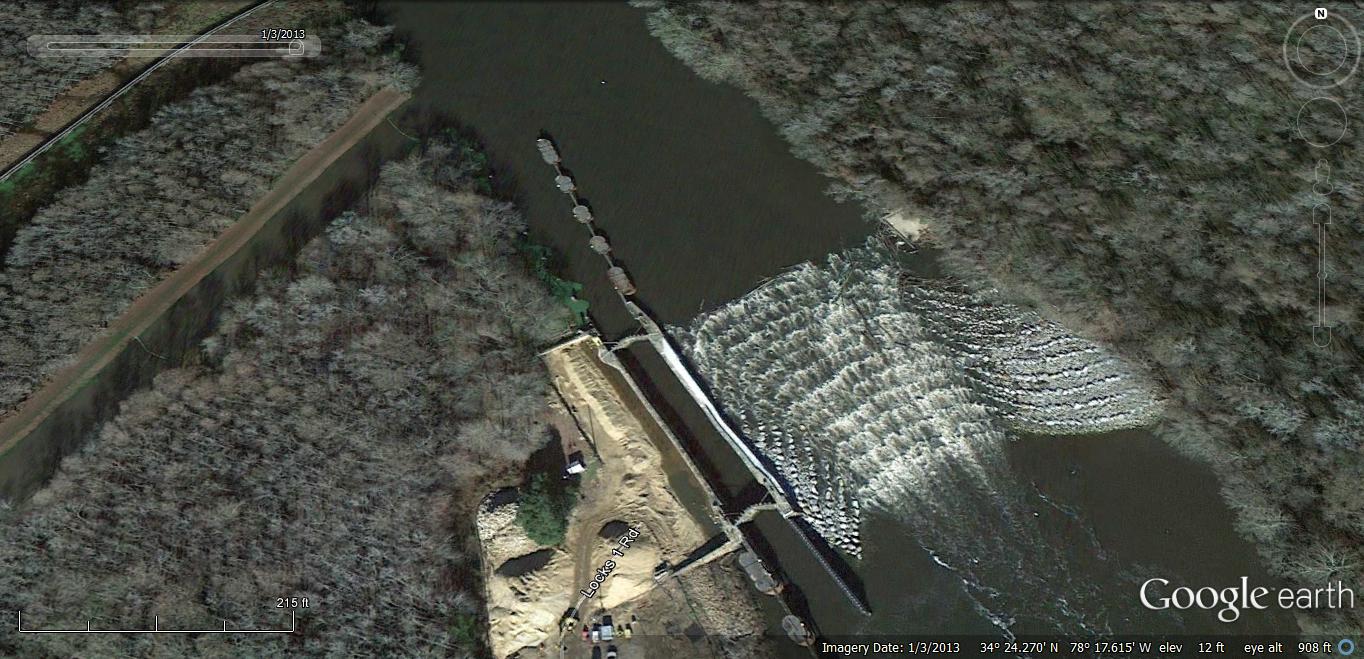
To help restore the natural migration of fish in the Cape Fear River, the Army Corps of Engineers constructed of a fish ladder at Lock and Dam one in Reigelwood last year. It’s the first one of its kind on the east coast of the United States.  Fish climb the stair-step like structure made from carefully placed rocks by leaping out of the water, level by level, until they’re over the twelve foot high dam.  It’s the first migrating season since the fish ladder has been in place, and Burdette says it’s being used.

“The Division of Marine Fisheries has tagged fish with sonic tags then they’ve gone out and collected this data and these studies show these fish are using these fish passages, striped bass and shad are both using these fish passages, they’re both moving upstream unassisted for basically the first time in one hundred years so it’s really a significant breakthrough for the Cape Fear River and the migratory fish in the Cape Fear River.”

Now two more Cape Fear fish ladders are in the planning phase. Two grant applications were recently submitted to the National and Oceanic and Atmospheric Administration to fund the design, construct, and monitor rock ramp fish ladders at the other dams on the Cape Fear River.

While one project focuses on helping migrating fish travel upstream, another project in the works will help restore breeding habitat.  Coastal Scientist Dawn York explains the project.

“Basically, the premise is to design a site where we can place about 1,000 tons of rocks down in an area that will help enhance spawning habitat for American shad.”

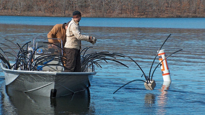
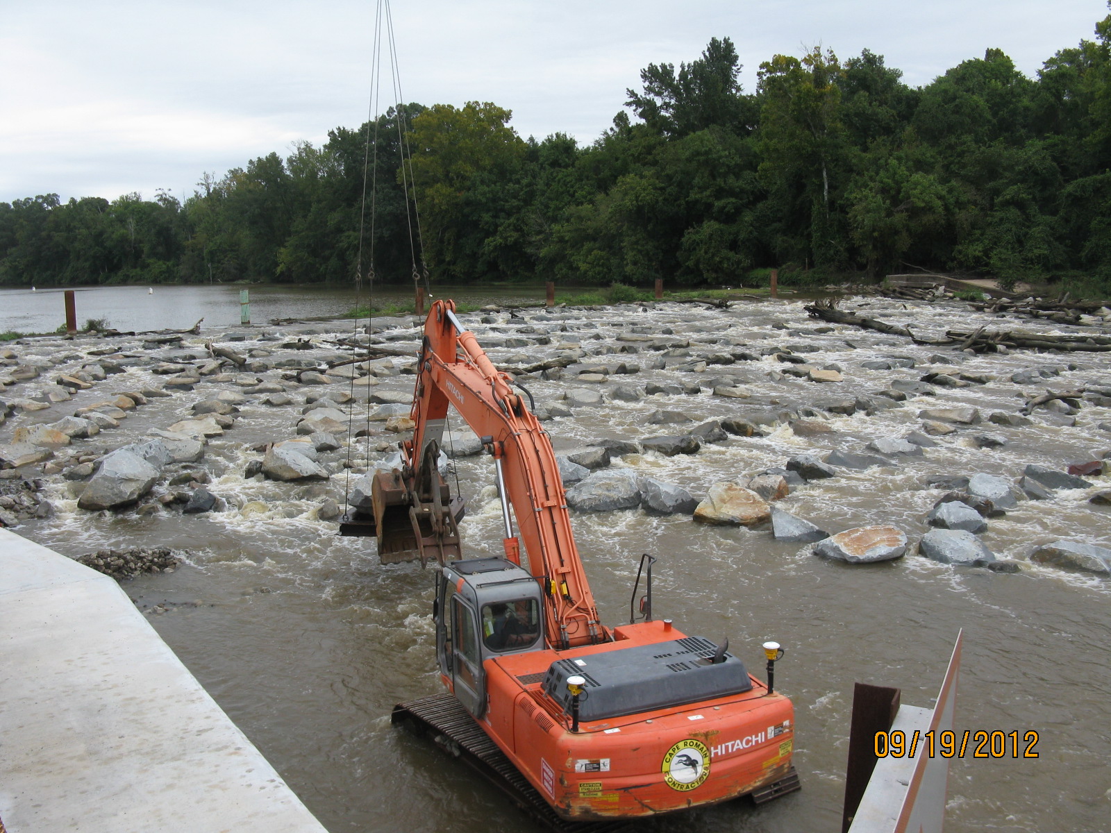
York is with Dial Cordy and Associates, an independent environmental consulting firm working with the Cape Fear River Watch as well as state and federal agencies on creating the fish habitat. She says the rocks will be placed at a half-acre area downstream of lock and dam 2.  An exact location for the habitat hasn’t been decided.  Crushed granite, ranging in size from 2 to 10 inches, will be set at the bottom of the Cape Fear River providing a safe place for striped bass, herring, and sturgeon to lay their eggs.  York says a dredging company in Wilmington will help facilitate the construction.

“They’ll travel up river it’ll take about 4-5 days to mobilize to lock and dam 2. They’ll use their excavator and smaller equipment to get the material onto a barge and they can handle about 90 tons per day. So we’re anticipating the construction of the restoration of habitat will take about 4 to 6 weeks.”

York says they want the first and last ton of granite material to be hand tossed into the water by volunteers.

“The rest of it would then be handled by the barge and mechanical means, basically an arm that will come down and grab large handfuls of material and place it into the river.  It’s going to be sort of spaced out over a half acre, so it’s sort of a flat area.

Construction should take place between December of this year and February 2014. The project can’t begin sooner because of a moratorium banning the placement of material in the water due to fish migration.  Cape Fear River Watch Riverkeeper Kemp Burdette says the next several months will be spent finding the best location for the new fish habitat.

“It’s not nearly as simple as taking rock out there and dumping it off.  What we’re really going to do is side scan assessments of the riverbed and what we’re trying to do there is understand what the riverbed looks like and what the substrate looks like and identify the best places to put the granite.”

Even with the project wrapping up in early 2014, Burdette says their work repopulating the waters of Cape Fear River with migrating fish species is far from over.

“The project at lock and dam number one was a huge first step, but it’s not the last step.  We still have two more dams we need to have fish passage around because we really need these fish to get up into the fall line, that’s the area where they want to spawn, that’s the area where spawning would be most successful and so that’s where we need to go.”

Even though the construction isn’t underway, the project is already receiving national attention.  The National Fish Habitat Partnership has listed the Cape Fear River as one of the “10 Waters to Watch,” for its locally driven conservation areas and ongoing efforts.

Fishing is permitted at all three lock and dam sites, however, there is a moratorium on keeping striped bass.  It is illegal to keep sturgeon because they are an endangered species.  A dock was recently installed at lock and dam number one downstream from the dam structure and Burdette says it’s a popular fishing site for shad.   If you’d like to see a picture of the fish ladder in place at lock and dam one in Reigelwood, go to publicradioeast.org.

For more on Cape Fear River Watches fishery restoration efforts, click here: http://www.capefearriverwatch.org/advocacy/fish-restorationBy JARED BRUMBAUGH

Cerro Gordo installs fish spawning habitat structures

 This winter Cerro Gordo County Conservation Board staff installed eight pea gravel fish spawning habitat structures in three county owned lakes.

By taking advantage of the reduced water levels of the lakes the staff was able to get equipment and material into the necessary locations to improve fish habitat. More habitat articles at fishiding.com

The county-managed lakes where the habitat improvement projects were completed are Fin and Feather and Clark Lake at the Mike Zack wildlife area and the lake at the Bluebill wildlife area. Three spawning beds were installed at Fin and Feather Lake, two at Clark lake and three at Bluebill.

The purpose of a pea gravel fish spawning structure is to improve the reproductive success of panfish species such as bluegill.

A process of panfish reproduction involves male fish creating a nest site by fanning out a bowl- shaped depression in the lake bottom to provide a site for females to lay their eggs in.

To create the nest the fish must use whatever bottom substrate is available.

In Iowa the majority of nests are constructed in mud or silt as this is the most common bottom structure of many lakes.

These types of nests are moderately successful but they can be easily disturbed and ruined by wind. Windy days stir up the mud and silt and deposit this material into the nests. The mud and silt deposited into the nests buries the eggs which reduces or eliminates nest success.

Recognizing this siltation problem, the County Conservation Board staff worked with an Iowa Department of Natural Resources fisheries biologist to find an improved spawning substrate for panfish in CGCCB managed lakes. The use of pea gravel as a nesting substrate was determined to be the best option available.

The pea gravel improves spawning success by providing a bottom substrate that panfish can still create a nest in, yet is more stable in windy conditions. Without the wind disturbance the nests stay intact and the hatching success of the eggs is dramatically improved.

Capitalizing on the reduced water levels this winter, the conservation board staff was able to place and level pea gravel at appropriate locations for each lake. The spawning beds are constructed by placing a four- to six-inch layer of pea gravel onto the lake bottom.

The layer of pea gravel is located at a depth that is at or slightly below the normal sunlight penetration point for that body of water.

In some lakes this may be two to three feet below the surface; in other lakes this may be eight to 10 feet below the surface. The spawning beds are approximately 15 feet by 30 feet. The completed spawning beds will provide enhanced spawning sites for the panfish in Fin and Feather Lake, Clark Lake and Bluebill.

The fish spawning structures will also provide increased fishing opportunities for anglers at these lakes. The increased spawning success should provide more fish for anglers to pursue via natural reproduction.

Also the spawning beds will be good places to actively fish during the spawning season. Since males typically guard the nests, catching a few fish off of the spawning structures will not greatly impact the fish population.

For more information about this project or where the above county lakes can be located go towww.co.cerro-gordo.ia.us (click on outdoors), stop by the Lime Creek Nature Center at 3501 Lime Creek Road in Mason City, or call the board office 641-423-5309.

Mike Webb is   By MIKE WEBB, For The Globe Gazette
Wildlife Area Manager, Cerro Gordo County Conservation Board

B.A.S.S. Federation Nation Improves Habitat with long Term Advantages

Artificial Habitat Benefits Bass Fisheries

DateFriday, March 8, 2013 at 9:21AM  ActivistAngler.com

Fisheries in West Virginia and New Mexico are showcasing a new generation of manmade habitat, thanks to innovative state conservation directors in the B.A.S.S. Nation (BN).

Both Jerod Harman and Earl Conway saw the need for effective and long-lasting habitat in reservoirs that endure huge water fluctuations on a regular basis. More habitat articles at fishiding.com

“Climate change is already impacting the Southwest,” said New Mexico’s Conway. “Over-allocation of water rights and drought have drained many reservoirs in New Mexico and west Texas. Shoreline and aquatic vegetation is gone and replanting is futile when lake levels fluctuate 20 feet or so every year.

“That’s where floating islands come to the rescue.”

In West Virginia, meanwhile, the West Virginia BN has teamed with a company that makes fish habitat from recycled vinyl and reclaimed PVC to build an “oasis for bass” in Sutton Lake, according to Jerod Harman.

It consists of pea gravel, spider blocks, artificial structures fromFishiding, and vegetation growing in a 5,000-square-foot cage on a mud flat, with a creek channel nearby.

“The artificial structures attract the bass looking for a place to spawn,” Harman explained. “The pea gravel provides the correct bottom structure for bedding.

“When the young bass hatch, the artificial structures help provide a protective environment. The periphyton (mixture of algae, microbes, and bacteria that forms the base of food chain) will provide nutrients for growth, and, later on, the small bass fry can relocate to inside of the vegetation cage for protection from predators.

“This is something that I am really excited about!”

Harman added that he believes the habitat made by Dave Ewald’s Illinois company, which features vinyl strips attached to a heavy base, will greatly enhance periphyton growth, as well as provide better cover for survival of young bass than will the spider blocks alone.

“The structures are ready for installation right out of the box, and David was great to work with,” the conservation director said. “I would definitely recommend these, especially for a small group of volunteers who need to complete a larger-scale project in a limited amount of time.”

Conway and the New Mexico BN also are growing periphyton, but on floating islands instead of vinyl strips. One of those islands, complete with spawning platform, won the 2010 Berkley Conservation Award and was the first step in what the conservation director hopes will be a major habitat restoration project for Elephant Butte.

Bruce Kania’s Floating Island International, a Montana company, has provided the New Mexico BN with prototypes and expertise.

“Floating islands aren’t new,” Conway said. “They occur in nature and have a proven track record for improving water quality and enhancing fish production, but I think that we are just beginning to realize how they can add an entirely new dimension to habitat restoration options.

“My experience is that the shade and food they provide makes them better fish attractors than boat docks or tire water breaks. They are being used more often in public waters and it is just a matter of time until someone wins a major tournament or catches a monster bass off a floating island.”

(This article appeared originally in B.A.S.S. Times.)

Floating Islands Southeast is offering a free webinar

Our first Webinar for 2013, BioHaven® Floating Island Technology Overview & Update, will be Friday, March 15 at 11am EST.

This is a FREE Webinar.

This session will provide an updated, general technology overview, and will include:

  • BioHaven® Floating Islands technology (Floating Treatment Wetlands)
  • Leviathan – adding circulation to increase results
  • BioCoral – increasing surface area
  • BioSwale – “in ditch” treatment
  • Living Shoreline – alternative to conventional solutions

We recommend/encourage inviting scientists, engineers, facility/municipality managers, and anyone interested in improving water quality, creating habitat and or preserving shorelines.

More habitat articles at fishiding.com

To join this free webinar, send an email requesting “log on” information to: info@floatingislandse.com.

You can invite as many others as you like, but they must also send a request for “log on” information.  Each “log on” is unique and they will not be able to use yours.

Please note – you must have the “log on” information that is provided by the webinar software ilinc.  About 24 hours prior to the session, you will get an email from the ilinc software that will provide you with your unique “log on” information.  If you have any questions, please call us at (888) 660-3473.

For ilinc technical support, please call (800) 799-4510.

BioHaven Floating Islands

Technology Overview & Update

Free – Webinar

Friday, March 15

at 11:00am EST

Submit your request to join this free webinar to:info@floatingislandse.com

24 hours prior to the webinar, you will receive the log on information and password to join this free webinar.  For ilinc technical support, please call (800) 799-4510.

BioHaven® Floating Islands biomimic nature and provide a “concentrated wetland effect” that can help solve many environmental problems challenging our water and wildlife. Unlike natural or constructed wetlands, they can be launched in any depth of water and are unaffected by varying water levels.

Floating Island SE

(FISE) is an exclusive and licensed manufacturer of BioHaven® Floating Islands and this proprietary technology.  FISE works with universities, municipalities, government agencies, engineering firms, private parties and various environmental strategic partners to design and sell customized solutions that leverage the BioHaven® Floating Island technology.

Phone: (888) 660 3473          Website: www.floatingislandse.com          Email: info@floatingislandse.com

Scroll to Top