StructureSpot

A $76 billion economic force.Hunters andAnglers: chapt #1

Chapter #1

A force as big as all outdoors:

Meals: $165  Fishing license: $30   New boat and trailer:  $52,000   ATV: $6,000

Motel: $69.95 x 5 nights   Boat registration: $60   Hunting license: $50   Gas: $75

Two weeks’ groceries: $300  GPS and walkie-talkies: $295    Gas $115

Polarized sunglasses: $90  Fish finder: $360   Boat winterization: $300

New rod and reel: $295   Flowers for my wife for letting me go fishing: $45

New rifle: $785   Cabin: $25,000  Property tax: $4,200  Hunting land : $115,000

Chain saw: $189     Trolling motor: $280    New boots and coat: $325

Taxidermy (with any luck): $450

A  dollar here .  A hundred dollars there .   It adds up to more than you might think.

America’s  34 million hunters and anglers are an  economic  powerhouse , driving  the  economy.  They’re  passionate about their pastimes and  they  spend passionately too.

Multiply individual  spending by those many millions of  people , and  you’re  talking  a major  force in our economy, through  booms as well as  recessions .  They directly  support 1.6 million jobs .  They  spend more than a billion dollars  just  on  licenses,  stamps ,  tags   and  permits, and  they generate  $25 bi l l ion a year in  federal , state and local  taxes .

By  any  measure , hunters and  anglers are among  the most  prominent  and  influential of all demographic groups. Hunters and  anglers  support  twice as  many  jobs  as  the combined  civillian  payrolls of  the Army, Marine Corps , Navy and  Ai r Force .

$208 million a day. $1.5 billion per week.  Annually hunters and anglers  spend  $9 billion to  lease and purchase land for their sports . That’s  enough  to purchase  27,000  new homes or rural  acreage larger  than  the states of  Rhode Island  and Delaware  combined.

No mortgage crunch here. Without  hunters and anglers, our economy would be a lot   smaller. $76 billion smaller, in fact. That’s how much they spend  each  year on their pass ion for the outdoors.  If a single corporation grossed as much as hunters and anglers   spend,  it would be among America’s  20  largest ,  ahead of  Target , Costco and AT&T.  Buthunters’  and  anglers ’  influence  goes   even  further.  They  create an economic “ r ipple effect “.  They keep people working: not  just   in  typical  hunting and  fishing  jobs ,  but also in ga s stations,  retail , restaurants  and hotels  throughout  every  state and  congressional  district of  the  USA.

There  are  other  numbers ,  too.  For   instance ,  Americans  spend more   time  hunting and  fishing  each  year  than days  spent running  the Federal  government   (737 mi l l ion days vs . 486 mi l l ion) . Together, hunters and anglers are a significant voting bloc. In fact, their voting potential was 31% of all votes cast in the 2004 presidential election. Eighty percent of sportsmen are “likely voters,” far more than the national average. They can change the tide of elections. And, as you might guess, they tend to favor pro-sporting candidates.

$8.6 million an hour. Spending by hunters  and anglers  is  more than the revenues of  Microsoft , Google, eBay and Yahoo—combined                                 (76 billion vs . 73.6 billion)

Higher earnings than high-tech. (34  MILLION VS . 27  MILLION ) More  people  hunt and fish  than watch the  nightly newscasts of  the three major  networks—ABC,  CBS, and  NBC.  Breaking news.  Hunting  and fishing  Americans  out  number motor- sport  fans  by more  than 2 to 1.   In  fact ,  they could  fill  every NASCAR  track 13  t imes over.

Racing ahead. If  the $76 billion that  sportsmen  spend on hunting and  fishing were the Gross Domestic Product of  a country,  sportsmen as a nation would rank 57 out of  181 countries .

On  lodging  alone,  hunters spend more than the annual  revenues of  Comfort  Inn, Comfort  Suites, Quality Inn,  EconoLodge,  Rodeway  Inn and Sleep  Inn  combined. Sleep on it.
 

Concerns still abound regarding Izard County sand mining

By Susan Varno

Sunday, May 22, 2011

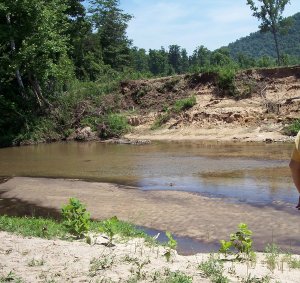
Mill Creek is shown after George Bartmess stripped vegetation from the bank in 2008. His property ends where the trees and vegetation begin.

Photo by Susan Varno / Contributing Writer

Mill Creek is shown after George Bartmess stripped vegetation from the bank in 2008. His property ends where the trees and vegetation begin.

THREE RIVERS AREA — The roar of a bulldozer on the banks of Mill Creek alerted residents in Izard County that their lives were about to change dramatically.

In February 2008, landowner George Bartmess stripped most of the vegetation from the creek bank on his property. He even plowed up some of the creek bed. Heavy rains washed sand and silt into the creek and downstream into Piney Creek. Piney’s gravel creek bed filled with sand and mud, threatening the smallmouth-bass habitat.

Barbara Carlson, who lives nearby, said Bartmess’ actions got the attention of his neighbors.

“Local people didn’t know Bartmess was planning to do sand mining,” Carlson said. “We came together and asked Friends of the North Fork and White River to help us understand the laws and environmental problems.”

The Friends helped residents form a chapter, Friends of Mill and Piney Creeks. Members of the new organization spent months studying frac sand mining, state and federal laws, and the permitting process.

They learned that B&H Resources LLC of Shreveport, La., had applied to the Arkansas Department of Environmental Quality for a quarry sand-mining permit. Beneath southern Izard County are thousands of tons of high-grade silica sand. Today, it is in demand as “frac sand,” used to help release natural gas from gas shale.

“We realized what Bartmess was doing was illegal,” Carlson said. “He was allowed to do nothing until his permit was approved.”

The group informed the ADEQ of Bartmess’ activity, and the department issued an emergency “cease and desist” order on June 19, 2008. Responding to the Mill and Piney Creeks group’s complaints, the Arkansas Game and Fish Commission ordered B&H to repair damages along Mill Creek.

“A small group became active,” Carlson said. “We tried to educate the public and publicize what was happening. Word was spreading. People were alarmed.”

Company owner Mike Hardy was the “H” in B&H. Bartmess was the “B.”

“After the cease-and-desist order, we had issues with Bartmess,” Hardy said. “We bought him out and reorganized as Evergreen Processing LLC. We had to start the permit process all over. We have voluntarily held public meetings since we began the permitting process.”

About 130 local residents attended a meeting on Oct. 5, 2009, at the Calico Rock Music Hall. Evergreen sent its consultants to outline plans for the 1,300-acre mining site. Engineer Dan Drinkwater said the quarry would cover about 300 acres. To wash the sand, the plant would use about 390,000 gallons of water a day, drawn from 2,000-foot-deep wells.

Concerned that using so much water would dry up homeowners’ wells, Friends of Mill and Piney Creeks invited John Czarnecki of the U.S. Geological Survey to a public meeting on Feb. 18, 2010, in Calico Rock. Czarnecki said the volume of the Ozark Aquifer, which flows beneath northern Arkansas, has never been measured for Izard County, so it is not known if there is enough water to support sand-mining operations.

Hardy said after the meeting that he asked his consultant geologist, David Williamson, to meet with Czarnecki to investigate the dynamics of the aquifer.

“We have 18 springs on the Evergreen property,” Hardy said. “The second-largest spring runs well and has about the same flow in wet and dry years. We asked the Arkansas Natural Resource Commission to look at the spring, and they felt it was a better fit. It will cost us more to build a five-mile-long pipeline with four pumps to move the water from the spring to the plant, plus yearly maintenance. We made the change because it just made sense.”

At the October 2009 meeting, Evergreen consultant Kevin Ware said that after the sand is washed, the water will be pumped into retention ponds. Polyacrylamide would be added to bind with the sediment and make it sink. Some of the “clean water” would be reused. However, an ADEQ permit allows the release of “clean water” into creeks that eventually flow into the White River.

Jeff Williams, trout biologist for Arkansas Game and Fish, spoke next. He said trout become stressed when temperature, turbidity, chemicals and/or sediment levels of river water change. The fish don’t feed or spawn well and are more likely to die.

Responding to these concerns, Evergreen redrew its plans over the next year.

Hardy said the new plan does not use sediment-binding chemicals.

“We will bring water into a slurry, which presses the sediment into clay bricks,” he said. “The used water will go into two ponds, 4 acres each, with a berm around them.”

The bricks will be used to refill the quarry.

Evergreen will also use much less water.

“We will draw water from the ponds back into the plant, only adding water for condensation and evaporation,” Hardy said. “When we start this plant, we will become part of this community. Questions and concerns from meetings quickened our decision to make some changes. We felt the changes would have less impact and be more sustainable.”

On Jan. 25, ADEQ held a public hearing at Calico Rock City Hall on Evergreen’s discharge and pond-construction permit. The company’s revised plan includes using spring water and storm water and only cutting trees and vegetation for roads, the quarry and the plant.

More than 60 people attended the hearing. In response to questions from the audience, Mo Shafii, ADEQ Water Division assistant chief, said the department, which is responsible for 6,000 permits and has only 15 inspectors, is only required to inspect a permit site once every five years.

“Permits are a self-policing system,” Shafii said.

However, the agency usually responds to complaints from the public within three days, Shafii.

According to media reports, in March, Evergreen completed planting 15,000 river birch, silver maple, sycamore and red oak seedlings and a variety of shrubs as part of the rehabilitation plan that Game and Fish ordered along Mill Creek.

Carlson said local residents will have to monitor what the plant discharges into the streams near the quarry.

“We have been effective because we approached all that was happening with calmness and rationality, asking how we could minimize the impact of sand mining,” Carlson said. “My feeling is, let’s try to protect the environment on the front end, so we won’t have to fix it on the back end.”

Kenneth Ballman, justice of the peace from Horseshoe Bend, also has concerns about Evergreen and the other two frac sand-mining operations in Izard County.

“Sand mining will contribute to the local economy,” Ballman said. “At Guion, 30 to 35 jobs; Evergreen, 30 to 35 jobs. Short-term, this will be good for our economy, but the long-term impact could be worse. I would like to see a study of the aquifer.”


Viewpoint – Water council supports RAR bylaw

By Contributed Opinion – Gulf Islands Driftwood

Published: May 25, 2011 10:00 AM

Recent criticisms about the proposed Riparian Areas Regulation (RAR) bylaw and the process for its implementation seem to have lost sight of its primary purpose. That is, to regulate activities on land that could result in contamination of critically important streams, lakes, wetlands and other water courses. Surely public health, in the form of safe, healthy water sources on our island, must be a clear priority.

The Salt Spring Island Water Council, comprising over 50 organizations, agencies and individuals involved with providing, protecting, conserving and managing drinking water on the island, strongly supports the overall intent of the proposed bylaw. We recognize that protection of fish habitat through the implementation of the RAR will also have the effect of enhancing the protection of our drinking water.

Water Council also agrees with the creative efforts of the Local Trust Committee to implement the bylaw in a way that would reduce the costs to applicants and expedite the approval process, provided it does not compromise public health concerns in the protection of vital drinking water supplies.

I’d like to address some of the criticisms being raised about the proposed bylaw.

The suggestion that this bylaw is being rushed through the process is emphatically wrong. The requirement to comply with the provincial RAR was made in March 2006 and, perhaps, should have been addressed in my term as a local trustee for the Islands Trust (2005-2008). However, a review of the development permit areas was planned but not undertaken over this period due to considerable work on other revisions to the OCP. Another two and a half years have passed. With extensive public input, a revised Development Permit Area 4 bylaw, incorporating RAR, has been proposed and is long overdue.

Concerns have been expressed about the scale of mapping that is needed. Since RAR applies to all defined “streams,” whether mapped or not, detailed mapping is not necessary to implement RAR. However, the Trust has proposed a reasonable compromise by identifying RAR designated watersheds on the island, within which the RAR would apply to a 30 m setback from any “streams.” In practice, according to staff estimates given in last week’s Driftwood, less than 10 per cent of the island land base could be affected.

Critics have proposed more certainty for landowners through detailed mapping of all possible “streams” that would be subject to RAR including ground-truthing and private landowner consultation. The costs are unknown, but likely high for the taxpayer and would further delay the bylaw. Even with such mapping, a site-specific assessment by a Qualified Environmental Professional could still be required for each application, at the applicant’s expense, at the time the application is made. Given the relatively few development permit applications that are filed and the proposal to have Trust staff provide an initial screening of applications, the proposed watershed mapping appears to be the most cost-effective approach.

I was pleased to read in last week’s Driftwood that the Trust is exploring a way to address the sensitive issue of roadside ditches, perhaps through a clear definition of ditches that would be subject to RAR with reduced setbacks and those that would be exempt. This would reduce the area of land affected even more.

In view of the above, and the urgency of protecting our increasingly threatened drinking water sources, Water Council urges the Local Trust Committee to proceed diligently with a final bylaw at the earliest opportunity accompanied by the proposed community information program to assist landowners and the development community.

Peter Lamb is coordinator of SSI Water Council and a former Islands Trustee.


Fishiding teams up with crappie and bass fisherman nationwide!

Not only has fishiding artificial fish habitat been used in private lakes and ponds for aquatic balance, but the pro’s in bass and crappie fishing on getting on-board fast. Since hitting the market just over two years ago, fishiding artificial fish attractors are taking fish habitat to a whole new level. For years fisherman and pond owners have been putting an array of products in their waters to provide much needed habitat for fish and aquatic life. Natural wood products continue to be used with success, only for a limited time. The industry has turned it’s direction towards artificial pvc products that won’t rot and stay forever in place.

The west Virginia Bass Federation has begun a pilot program with the fishiding fish habitat products to see if they can resolve a problem they have in many of their waters. Seems that they have trouble getting algae to grow quickly if at all on fish structure they have used in the past. These guys and gals put in countless hours of their own time to build, install and maintain hundreds of fish structures throughout the state.

What we know about fishiding is that it grows algae fast everywhere it has been installed, now in over 40 states. High water and flooding has kept the units from being installed but soon will be in the water holding fish. Much better than buried in a landfill.

The Bass Federation is hoping to install fishiding artificial fish habitat products throughout the state waters as well as all the states but two in the nation. Only Hawaii and Alaska do not have a Bass Federation chapter , with all the others eagerly involved. Stay tuned for results and information as to where the units have been installed.

Recently, fishiding.com was contacted by the West Alabama Crappie association and the Tenn Tom Crappie Club to sponsor their next two tournaments. These folks love to fish and install habitat, especially for crappie. Numerous sizes and models of fish habitat made from reclaimed pvc will be raffled off and awarded to winners at various events. Fishiding products are all made with an entirely green approach from the pvc material to the cardboard and newspaper used in shipping. All measures are taken to re-use and reclaim products to save the environment as well as the final cost.

Fishiding.com offers sizes of fish habitat from small Koi and garden pond fish made from fine strands of pvc, to large 84″ diameter fish attractors with wide flat limbs to cast maximum shade for the largest of predators.

Coming soon will be pre-packaged bundles of rigid sticks of pvc to be used as stakebeds. This stiff, long lasting material will hold crappie right where you want them and only you will know the spot.

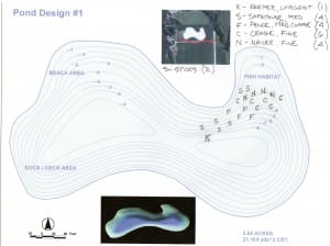
Another often forgotten or looked over step in the process is actual fish habitat design. In the past only a few types of artificial fish habitat were available and manufacture’s seem to assume folks know what to do. We have learned that there is a great deal of thought that can and should go into habitat placement planning. With the various sizes, textures and shapes of fish attractors fishiding.com now offers, the blueprint for sucesss has never been so attainable. Depending on a clients goals, many choices are available. Shallow water cover to protect and grow fry and forage is now available exclusively with the fishiding cradle and garden pond sizes. Mid depth fish structure comes in the safehouse model, designed to give fish a route to follow as they move from 2-4 foot depths in to the 6-10 foot range. Once fish have grown to the optimal predator size, they will hide and hunt in the deeper water on the edge of the main lake basin. This is where the keeper model excels in holding large fish.


No matter what your goals are, or what shape your fishery is in, fishiding.com has fish habitat custom tailored to help your fish grow big and healthy. We will work with your budget to come up with a plan to keep your fish safe ,happy and full. After all, it’s about the fish.

TABLE ROCK LAKE FISH ATTRACTOR LOCATIONS

TABLE ROCK LAKE FISH ATTRACTOR LOCATIONS UPDATED WITH 2011 FISH ATTRACTORS

The following link directs you to a web site that displays Table Rock Lake fish attractor locations. This site is a partnership between the U.S. Army Corp of Engineers and the Missouri Department of Conservation. Using the Map Identify tool you can see the latitude and longitude of the fish attractor. Use this link, Table Rock Lake Fish Attractor Locations


Scroll to Top