StructureSpot

Nova Scotia cares about fish habitat

Clean Nova Scotia. Inspiring environmental Change

Nova Scotia Fish Habitat Assessment Protocol (NSFHAP)

Nova Scotia Fish Habitat Assessment Protocol (NSFHAP)

Clean Nova Scotia, in collaboration with the NSLC Adopt-A-Stream, is working on the development of a standardized fish habitat assessment methodology for specific use in Nova Scotia. The methodology is intended to be used by the various groups involved in the protection, restoration, and assessment of aquatic ecosystems and will aid in the accurate assessment of fish habitat in our local rivers. This will help identify restoration needs, impacts of poor practises, and protection efforts.

See the dozens of unique artificial fish habitat models, fish attractors and fish cover used at fishiding.com, the leader in  science based, proven, fish protection.

The methodology will incorporate the use of Habitat Suitability Indices (HSI) to provide meaningful and accurate results from data collection in the field. Habitat variables are assessed in the field and are related to water quality, river morphology and hydrology, river banks and riparian vegetation, and benthic macroinvertebrates. The methodology will be modular and varying in the level of depth required so groups with different resources are able to effectively assess their rivers. The methodology will enhance our understanding of fish habitat and populations, lead to effective restoration and protection projects, and improve the health of our aquatic ecosystems.

Counties receive several grants to improve fish habitat

Cowlitz County has a $204,000 grant to remove this bridge on Abernathy Creek.

See the dozens of unique artificial fish habitat models, fish attractors and fish cover used at fishiding.com, the leader in  science based, proven, fish protection.

Several groups that work to improve habitat for endangered fish have been awarded more than $1 million for projects in Cowlitz County. Clark County projects on the Lewis River total $925,383 and money for work in Wahkiakum County totals $361,505.

The grants announced recently by the state Recreation and Conservation Office come from federal and state funds dedicated to fish recovery. The money for the grants comes from the federal Pacific Coastal Salmon Recovery Fund and from the sale of state bonds.

The level of fish funding for most parts of the state has decreased over the past few years. The statewide total of $30 million recently awarded compares to $32 million in 2010 and $42.8 million the year before, said Susan Zemek, communications manager for the RCO.

In addition, grants for fish habitat work in Puget Sound total $13.5 million this year, compared to $33 million a year ago.

Cowlitz County

• Reshaping Abernathy Creek, $486,305. The Cowlitz Indian Tribe will use this grant to remove an abandoned roadbed on the east side of the creek that inhibits full connectivity between the creek and its floodplain, and place logjams in the creek to increase habitat. The tribe will excavate channels through the former roadbed and place logjams in the main channel, allowing the river to meander. The work is on state land.

The tribe will contribute $85,819 in donations of cash, labor and materials.

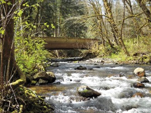
• Removing an Abernathy Creek Bridge, $204,000. Cowlitz County will use this grant to remove a bridge on an abandoned portion of Abernathy Creek Road. The bridge is 6 1/2 miles up the creek, near Brentwood Road. The bridge constrains the channel and limits the creek’s ability to meander and connect with its floodplain. The county will install logs and tree root wads in the creek and replant its banks after the bridge is removed

Cowlitz County will contribute $36,000.

• Restoring Andrews Tree Farm waterways, $177,401. The Cowlitz Conservation District will use this grant to restore portions of the Coweeman River and a tributary, Turner Creek, on the Andrews Tree Farm. The district will install logs and whole trees in the streams to slow the river, encourage gravel accumulation and create places for salmon to rest and hide from predators. The district also will plant trees along stream banks to shade and cool the water.

The conservation district will contribute $40,000 from a state grant and donations of equipment, labor and materials.

• Restoring Nesbit Tree Farm stream, $89,100. The Cowlitz Conservation District will use this grant to restore a portion of the Coweeman River on the Nesbit Tree Farm, which is about 8 miles up Rose Valley Road. The conservation district will place logs and whole trees in the river to trap sediment on exposed bedrock to improve salmon habitat and cool the water.

The conservation district will contribute $20,000 from a state grant and donations of equipment, labor and materials.

• Restoring the Coweeman River, $124,000. The Conservation District will use this grant to place logs and whole trees in the Coweeman River on the Baxter and Andrews tree farms about 6 1/2 miles up Rose Valley Road to improve habitat for salmon. The logs and trees will slow the river, encourage gravel to accumulate and create places for salmon to rest and hide from predators.

The conservation district will contribute $24,500 from a state grant and donations of equipment, labor and materials.

Clark County

• East Fork of the Lewis River, $212,753. Clark County Public Works will use the money to grade the outlets of two side channels of the river, install logs and root wads that act as juvenile fish habitat, and remove invasive plants and replant with native species. The project will expand side channel habitat by 3,500 square feet. Clark County will contribute $61,891 to the project.

• North Fork of the Lewis River, $401,730. The Cowlitz Tribe will use the money to place logs and jams into two side channels of the river, remove invasive plants along the bank, and replant the area with native trees and shrubs. The tribe will contribute $91,400 from a local grant and donation of labor and materials.

• East Fork of the Lewis River at Daybreak Park, $143,900. Fish First will enhance two side channels of the river, install wood structures in the river for habitat, and replant streambanks with native trees and shrubs at the park. Fish First will contribute $26,100 in cash, labor and materials.

• Eagle Island-North Channel Restoration Project, $167,000. Lower Columbia Fish Enhancement Group will use the money to design a project to restore optimum water flows in the north channel of Eagle Island, which is located in the North Fork of the Lewis River near Woodland. Optimizing the water flow will improve 2.2 miles of high value fish spawning and rearing habitat below Lake Merwin. Pacificorp and the state departments of Natural Resources and Fish and Wildlife are partners.

Wahkiakum County

• Grays River, $226,180. The Lower Columbia Fish Enhancement Group will install wood structures on Columbia Land Trust property in the Grays River to reduce water velocity, create habitat diversity and collect sediments against the toe of eroding stream banks. The structures will create pools, collect flood debris and stabilize the river channel. Additional structures will be placed along more than a half-mile of shoreline to protect important chum salmon habitat in nearby Crazy Johnson Creek. The enhancement group also will remove non-native plants and replant the area with native trees and shrubs.

The enhancement group and Columbia Land Trust will contribute $76,300 in donations of equipment, labor and materials.

• Elochoman River, $135,325. The Wahkiakum Conservation District will use this grant to place logs and tree root wads in the Elochoman River, to slowing the river and creating places for salmon to rest and hide from predators. The logs and root wads also help stabilize the channel by reducing erosion and protecting young trees on the riverbanks. The work will improve salmon habitat along more than a half-mile of the river and create a streamside forest on 4.5 acres.

The conservation district will contribute $39,500 from federal and local grants and donations of equipment and labor.

Can I just toss my Christmas tree on the ice for fish habitat?

When the ice comes, the temptation to place fish attractors often comes to mind especially on a farm pond. If no ice, then a boat might be used. But just weighting down a couple of Christmas trees and dropping them in, may not achieve the best results.

DNR has this to say:  There are many ways to recycle Christmas trees, but tossing on a frozen lake as a way of creating fish habitat has certain requirements — and an uncertain outcome. Instead of waiting for an iced-over lake to thaw so a single Christmas tree can sink to the bottom, Bill James fisheries section chief has this to say.

“They need to be designed, sized and placed appropriately to attract and hold fish.”  He said,  “Large hardwood brush piles work well and last for many years.  Soft woods such as pin or spruce attract fish initially but deteriorate quickly. This is especially true if use Christmas tree are placed singly or just scattered about.”

State laws may apply, depending on the body of water.  Discarding a Christmas tree on a private pond is at the owner’s discretion, but doing so on a public freshwater lake is governed by the Lake Preservation Act. See the dozens of unique artificial fish habitat models, fish attractors and fish cover used at fishiding.com, the leader in  science based, proven, fish protection.

I have placed Christmas trees and have seen the results a couple of years later, both on farm ponds and Lakes  when the water is down.  Christmas trees tend to lay flat on the bottom and shortly become covered with sediment , offering little cover for fish.

On the other hand, a brush pile of hardwood limbs, wired together to maintain it’s shape will be there for years if weighted enough to stay in it’s location.  For further info Google “Fish Attractors” .  There are many home-made designs that work for years and do not deteriorate.

Take a look at fishiding.com. They make artificial fish habitat out of things like reclaimed pvc siding, saving landfill space and helping future generations of fish and fisherman alike.

Culverts open up new fish habitats

Swimming against the current won’t be quite as hard for fish in parts of the Siuslaw basin thanks to a project that replaced 11 culverts on creeks southwest of Eugene.

The culverts opened a passage to upstream habitat on three creeks that was effectively blocked by the old pipes. Buck, Hawley and Esmond creeks could start seeing runs of coho and chinook salmon and steelhead trout as a result of the fixes. See the dozens of unique artificial fish habitat models, fish attractors and fish cover used at fishiding.com, the leader in  science based, proven, fish protection.

The $1.5 million project took place over the summer and was funded with a federal stimulus grant. Road repairs also were done as part of the project.

The work took place on the U.S. Bureau of Land Management’s Eugene District. The creeks all feed into the Siuslaw River drainage. The new culverts replaced old pipes that were failing or that blocked fish passage because of their small size or erosion around the outlets.

Jennifer O’Leary, a BLM spokeswoman, said the new culverts are specially designed to aid fish. Not only are they larger in diameter, they also are oblong in shape to create a wider, more natural passage.

Also, rocks and sediment are placed in the culvert to simulate the natural creek and slow the water so it flows at the same speed as the rest of the creek.

“What this does is allow for more natural rates of flow while restoring the natural width of the stream channel,” she said. “It’s all about restoring more natural conditions out there in the watershed.”

Many older culverts aren’t big enough for the stream volume, causing water to speed up and jet through the pipe, clearing out any natural material and making it hard for fish to navigate upstream. And because of erosion on the downstream side where water exits, many older pipes now sit well above the stream level, blocking young fish from migrating downstream.

With the new culverts in place, fish will have an easier time. That means areas that had been off limits before will now be reachable.

“The habitat above these (new) culverts is healthy and intact,” said Leo Poole, fisheries biologist for the BLM’s Siuslaw Resource Area. “All we needed to do was open up the passage for fish and other aquatic species to get there.”

Work on the creeks only can be done during a summer window from July 1 to Sept. 15. To get all the culverts replaced in that relatively brief opening, the BLM worked with an agency of the Federal Highway Administration known as the Western Federal Lands Highway Division.

That agency contracted with area engineering and construction firms to design and build the culverts. The number of jobs created by the project wasn’t available this week, but O’Leary said it was at least a dozen and possibly more.

The BLM has done a number of other projects aimed at improving fish habitat in the area. Previous work added boulders and gravel to portions of the Siuslaw River, creating spawning beds, lowering water temperature and providing refuges where fish can rest.

BY GREG BOLT

The Register-Guard

Maryland population grows, don’t forget the fish.

About the Fisheries Habitat and Ecosystem Program:

“LAND CONSERVATION IS FISH CONSERVATION”

The Fisheries Habitat and Ecosystem Program (FHEP) is working to understand how habitat changes impact Maryland’s fisheries in the Chesapeake Bay. Our focus has been primarily on understanding how urbanization limits habitat for fish. See the dozens of unique artificial fish habitat models, fish attractors and fish cover used at fishiding.com, the leader in  science based, proven, fish protection.

Maryland’s population and land use has increased significantly. The amount of land being developed outpaces population growth. Between 1973 and 2010, developed land increased by 154 percent while population grew by only 39 percent. By 2035, 1,000,000 new residents and 500,000 new homes will be added to Maryland according to the Department of Planning.

Studies by the Fisheries Habitat and Ecosystem Program have found strong links between increased development and declining fish habitat quality in tidal tributaries of Chesapeake Bay. These links have led to creation of thresholds and targets for development to consider when managing fisheries and planning for development. These thresholds and targets use impervious cover (hard surfaces such as pavement and rooftops that are impenetrable to runoff of rain and snow melt) as a measure of development. Impervious surface thresholds describe tipping points where habitat becomes poor for fish and shellfish. This is the upper limit of impervious surface. Development beyond this limit will severely limit habitat for fish and shellfish. Impervious surface targets describe a development level that can be considered safe for fish and shellfish habitat. These targets and thresholds are being communicated to planners and the public through a simple message, “land conservation is fish conservation!” as a reminder that forests, wetlands, other natural areas, and working farms are keys to productive Chesapeake Bay fisheries.

It is clear that development is a major threat to Maryland’s natural resources and the critical ecosystem functions provided by watersheds. The impact of development on aquatic habitats is quite well documented in the scientific literature. Impervious surface increases flow extremes (lower lows and more flooding), erosion, and sediment. As trees are lost, runoff temperature of water increases. Nutrients from developed lands can be as plentiful as nutrient inputs from agriculture and cause algae blooms that deplete oxygen. In winter, more roads require more salt that pollutes streams and kills freshwater organisms, including fish. Other pollutants such as toxic metals (lead for example) and organic pollutants (oil, grease, and pesticides) enter waterways in urban runoff and wastewater. Some compounds that enter wastewater treatment facilities may not be removed. These compounds may reduce success of fish spawning and make fish less safe to eat. Fish become less abundant and less diverse in polluted waters that result from high development and impervious surface.

“Every Maryland citizen lives within at least 15 minutes of a stream or river” – Maryland StreamHealth

The Fisheries Habitat and Ecosystem Program’s Mission:

FHEP Goals and Objectives

Our goal is to develop ecosystem-based fishery management strategies that will sustain fish communities in the future. In order to do this, we are working to identify fishery and ecosystem interactions with land use and water quality stressors. We work with the public and other local, state, and federal government agencies to enable Maryland’s Fisheries Service to develop ecosystem-based fishery management strategies that sustain services by fish (including shellfish) communities into the future. The role of others in ecosystem-based management is important since Fisheries Service (and even DNR) does not have authority to manage whole watersheds.

  
The Maryland Department of Natural has developed general impervious surface guidelines based on watershed size and management concern (e.g. rare, threatened, and endangered species, sportfsh management, etc.). The FHEP has adapted these thresholds and consider them when evaluating the status of the Chesapeake Bay’s fisheries. The categories for the Chesapeake Bay fisheries are:

  • 5% or less Impervious

Watersheds with 5% or less impervious surface represent target conditions. They have healthy fisheries. Habitat within the watershed is productive. Active engagement by the public and planning officials should be taken at this stage to protect, conserve, and sustain healthy fish habitat.

  • 5% – 10% Impervious

Fish habitat in watersheds between 5% – 10% impervious surface may begin to decline. Fish reproduction may become less successful as spawning habitat becomes increasingly impaired. Habitat for juvenile and adult fish becomes increasingly compromised. The public and planning officials need to conserve remaining habitat, minimize additional impacts, and revitalize damaged areas.

  • 10% or Greater Impervious

Watersheds with 10% or greater impervious surface are facing the “point of no return” of a tidal tributary to a very different and less productive status than when the watershed was less developed. Fish habitat is impaired from a variety of stressors at this stage and could be beyond the point of no recovery as development continues. Restoring a watershed to its target condition is very unlikely, but some functions might be reconstructed with limited positive success. Ecological reconstruction projects such as stormwater retrofit, impervious surface removal, or tree planting/revegetation can help mitigate impacts by reducing sedimentation and infiltrating groundwater. However, watersheds with greater than 25% impervious surface are highly altered systems, with little chance of restoring ecological integrity. Studies of restored streams do not show successful biological restoration in highly urbanized areas. In these cases, the public and planning officials should first restructure and redevelop areas of impervious surface in a watershed before attempting restoration projects.

What Can Fishermen Do?

Understand and learn what is happening in your backyard…

As fishermen, who use and enjoy Maryland’s natural resources, it is important for you to understand and learn what development and environmental impacts are occurring “in your own backyard.” The following links provide information and facts about the areas in which you may fish and-or live.

Fishermen and the public can get engaged in the planning process…

Fishermen are familiar with Maryland’s natural resources; however, there may be times in which you, as a fisherman, feel that you have no control in what is occurring around you and to your natural resources. If you are concerned you can engage in your county and watershed planning processes. The following links provide information and contacts that can help you take part in the development and land use decisions taking place in your watershed and community.

Hopes Raised for Lake Dredging and fish habitat

test4Lake Gregory dredging tour

Photo by Mike Harris

Lake Gregory dredging tour

Phil Krause, county park planner, points to areas on a map of Lake Gregory where silt has built up over the past few years. Krause was conducting an orientation tour of the lake on Dec. 21 for representatives from California Fish and Game, Lahontan Regional Water Quality Control Board and Lake Gregory Improvement Committee.

A major step toward getting approvals to dredge Lake Gregory was achieved Dec. 21 when representatives from regional agencies visited the lake for an orientation tour.

On hand for the tour were representatives from California Department of Fish and Game, Lahontan Regional Water Quality Control Board, Lake Gregory Improvement Committee and county Regional Parks Department. A representative from the Army Corps of Engineers was scheduled to attend, but canceled at the last minute. See the dozens of unique artificial fish habitat models, fish attractors and fish cover used at fishiding.com, the leader in  science based, proven, fish protection.

“The meeting was an excellent first step in terms of our working to get Lake Gregory dredged,” said Keith Lee, county regional parks director, who was present for the tour. “The different agencies’ representatives were incredibly helpful in providing solutions.”

The group assembled in the North Shore parking lot at 1 p.m., where Phil Krause, county park planner, started the tour with a briefing on past dredging efforts. He explained how silt and debris flowing into the lake from the silt basin near the new county library building has created large sand bars in the swimming area, limiting visitor access.

Another source for the silt is storm drains, especially those near the ball field.

After the briefing, the members walked over to the silt basin to see the area, then moved on to other areas around the lake, including areas near the Leisure Shores Community Center and the ball field where silting is a major issue.

“I think we’re moving along in a good way,” Lee added. “We won’t be able to get away from doing some California Environmental Quality Act (CEQA) work, but we’re looking for ways to work together to dredge the lake and get it back to the condition that I think many in the community would like it to be in.”

Members of the Lake Gregory Improvement Committee who were on hand for the tour included Aaron Creighton, Rick Dinon (who leads the committee), Mick Hill and John Short.

“We have continually emphasized to the regulating agencies that Lake Gregory is not just a county asset, but an important asset to the Crestline and Lake Gregory community,” said Dinon. “The good news is that we’ve encountered a lot of cooperation.”

Committee member Aaron Creighton said he also was pleased with the response from the Fish and Game and Lahontan representatives who took the tour.

“We now have a vastly greater view of what needs to be done,” he said.

Creighton said that in order to get permitted by Fish and Game and Lahontan, the county has to be in compliance with CEQA.

“One of the tricky parts under CEQA is that if we remove habitat, we will have to mitigate the removal,” Creighton said. “There are two areas at Lake Gregory that need to be dredged, and the two have quite a lot of habitat.”

Part of the talk during the tour centered on creating separate habitat areas, and how it might be possible to make habitat areas protected. Other ideas included creating fish habitat areas in the deeper parts of the lake by depositing used Christmas trees weighed down by cinder blocks.

Creighton said one of the comments included that by pulling silt out of the lake, it would help improve the water quality.

“We will need an environmental impact report, and probably have to have a biological report,” he said. “We have heavy-duty problems at this lake.”

By Mike Harris, Reporter

Scroll to Top