StructureSpot

Fish Habitat News

Action Plan News Williams Run, Pennsylvania
Williams Run, Pennsylvania
MONDAY, 09 NOVEMBER 2009 15:06
Williams Run is a tributary of South Sandy Creek in Venango County, PA.  Aquatic habitat in Williams Run has been severely damaged since coal mining activities produced acid mine drainage in the stream.Valerie Tarkowski (South Sandy Creek Watershed Association) surveys Algae growing near the headwaters of Williams RunWater conditions were degraded with a very low pH, no alkalinity, and both iron and aluminum contamination. This point-source pollution left the stream uninhabitable for brook trout and other aquatic life.  Williams Run is currently listed on the Pennsylvania Department of Environmental Protection’s 303d List of Impaired Streams.See the dozens of unique artificial fish habitat models, fish attractors and fish cover used at fishiding.com, the industry leader and only science based, man made and artificial fish habitat, proven to provide all fish with cover they prefer to prosper.

Williams Run represents waterways across the country, including lakes and reservoirs, that are improving through the conservation efforts of the National Fish Habitat Action Plan—a bold initiative to reverse persistent declines in aquatic habitat.

Thanks to the combined actions of concerned community groups, nonprofit organizations, and state and federal agencies, these waters are being improved by planting stream-side vegetation, removing impediments blocking fish habitat and protecting waterways from the effects of industrial processes, specifically acid mine drainage (AMD).

With funding provided through the Eastern Brook Trout Joint Venture, the South Sandy Creek Watershed Association (SSCWA) is working with a host of public and private partners to bring Williams Run back to life. Construction of a passive limestone bed will restore water quality and allow aquatic species, such as the brook trout, to naturally return to Williams Run.  Additional funding is provided by the Office of Surface Mining and the National Fish and Wildlife Foundation.

This restoration is expected to provide a unique remote trout fishing opportunity on public lands managed by the Pennsylvania Game Commission.

In recognition of the partnership efforts and potential to significantly improve aquatic habitat, Williams Run has been selected from among projects across all 50 states as one of the National Fish Habitat Action Plan’s “10 Waters to Watch” for 2008.

Local organizers of the restoration are thrilled with the national recognition of their efforts.  “It’s been a long fours years to get from the founding of our organization to this point, and there were efforts by other groups before ours, said Larry Wheeler, president of the SSCWA, but you can really see the results on the ground now.”

Williams Run tributaries are already home to wild brook trout populations, and restoration of the Williams Run mainstem will add another 9 miles of healthy stream habitat. Williams Run flows into South Sandy Creek, Sandy Creek and the Allegheny River, all sustainable waterways for healthy fish populations.

Other project partners include private landowners, Mineral Township, and PA Senior Environmental Corps, as well as PA DEP’s Cambria County office of the Bureau of Abandoned Mine Reclamation and the Pennsylvania Fish & Boat Commission, both of which provided monitoring and technical assistance, and many others. Construction began this summer and is expected to be finished at the end of 2008, with immediate benefits to water quality in Williams Run.

Williams Run is located in southwest Venango County, mainly on State Game Lands 39.

View Williams Run Project Profile (PDF)

Federal officials deem waters environmental success story

Published: Saturday, July 02, 2011

By RICHARD PAYERCHIN

rpayerchin@MorningJournal.com

LORAIN — Federal officials agreed the Black River is an environmental success story with more chapters to come.

Lorain officials hosted a reception and river tour for local partner groups and officials from the federal National Oceanic and Atmospheric Administration, which contributed $1.69 million for fish habitat restoration in the river. The tour also was an introductory event for the holiday weekend, which features Independence Day celebrations along with Port Fest and the inaugural Black River Kayak-a-thon river race.

Staff from NOAA and the Great Lakes Commission praised the city’s efforts to remove slag piled along the river’s shore and restore a natural flood plain behind Lorain’s steel mill.

Restoring the river’s ecology also will help Lorain’s economy as more people venture onto the Black River to boat, sail, paddle and fish, said John Iliff, regional supervisor for the Great Lakes Restoration Program of NOAA.

“This project absolutely stood out,” Iliff said, as Lorain competed with 60 other projects for limited federal funding.

It was his first trip to Lorain to see the work paid for with federal money.

“The Black River, ecologically it’s sound,” Iliff said. “The Black River itself is beautiful. It has a lot of hidden beauty that’s not visible as you’re just coming through the highway corridors and the bridge corridors. The Kayak-a-thon is going to start to really open people’s eyes to the recreational opportunity the Black River is. I think there’s great potential both ecologically and economically, recreationally for the folks who live here.”

The project likely will become an example that Great Lakes advocates use when talking to Congressional leaders about money for environmental restoration, said Matt Doss, policy director for the Great Lakes Commission in Ann Arbor, Mich.

The Black River is a prime example of remediation to restoration — cleaning up problem areas and replacing the bad items with good ones, Doss said.

“As I went up the river today, it’s beautiful,” Doss said. “You saw kayakers and fishermen and I’ve dozens of pictures of herons and it’s just beautiful. I’m really impressed.”

The day included river tours for local, state and federal officials aboard the Lorain Port Authority boats.

The vessels ventured upriver to rendezvous with researchers from the Midwest Biodiversity Institute, who used electrical current to stun fish in the river, then count them.

As the vessels moored alongside each other, Roger Thoma stole the show as he picked up fish the crew had caught. Lorain Utilities Director Corey Timko, who spoke at the reception, spoke of his experience studying with Thoma and credited his vision for inspiring efforts toward Lorain’s Black River restoration.

The catch included largemouth bass, bluegill, pumpkinseed sunfish, rock bass, freshwater drum, golden shiner, bluntnose minnow, gizzard shad and channel catfish. He explained to the passengers each species, including why they are important in the environment and how they taste when cooked. The crowd chuckled as several fish flopped out of Thoma’s hand and into the holding tank.

The restoration project includes piled stones called “fish shelves” design to create habitat where plant will grow and fish will rest, eat and spawn.

The Black River already has plants growing along shore but needs more vegetation in the water to improve the river’s ecological health, Thoma said. The minnows like vegetated areas and other fish, such as the bluegill and largemouth bass, go there to feed, he said.

“Again, we’re back to that issue of vegetation and getting that vegetation going up here in the Black River so that the fish will follow,” Thoma said. “There’s a lot more to vegetation than just the fish.”

The Black River looked cloudy and green because algae was growing on nutrients in the river, Thoma said.

“If we had enough vegetation in the river, the vegetation would suck up those nutrients and the algae wouldn’t grow as abundantly and then the water would be clearer,” Thoma said.

The river trip concluded with a view of three bald eagles soaring in circles over the shore. The birds were distant, but their white tales clearly were visible when the sun shone on them.

“It looks beautiful, it looks great,” said Vickie Thoma, a Lorain native and wife of Roger Thoma. “How majestic. What a great day.”

Fish Habitat Program

Fish Habitat Program

Funding assistance is available to County Conservation Boards for land acquisition and development of fish habitat. Up to 90 percent of costs may be reimbursed under this program. Land must be under the direct control of the county to be eligible for assistance. This program is unique in that the applications are sent to the County Conservation Board Districts for review and selection of projects.

Available funds are divided equally between the six county districts. Approximately $70,000 will be available this grant cycle.

Eligible development activates include:

  • Physical placement of fish habitats in ponds, lakes, pits and streams
  • Armoring of pond, lake pit and stream shores.
  • Construction of aeration systems
  • Dredging of ponds or lakes
  • Construction of sediment retaining basins
  • Repair of lake dams and outlets
  • Manipulation of fish populations and aquatic vegetation
  • Removal of dams
  • Construction of fish ladders
  • Construction of fish barriers
  • Construction of rock-faced jetties

Acquisition projects are eligible when the land is used for fish habitat development purposes. Project activities eligible for funding include:

  • Land acquisition for pond and lake construction
  • Land acquisition for fishable streams, ponds and lakes
  • Land acquisition for watershed protection

Applications are due on the last working day in November of each year. The applicant should submit seven copies of the grant application to the review and selection committee chairperson within the appropriate County Conservation Board District. The committee will review the applications in January and then forward the results to the DNR.

The Minority Impact Statement Form is required to be filled out and sent with your application:
Minority Impact Statement Form

Fish Habitat Program Grant Application

For more information or to have an application mailed to you please contact Mimi Habhab at 515-281-5034 or by e-mail at Mimi.Habhab@dnr.iowa.gov.


See the dozens of unique artificial fish habitat models, fish attractors and fish cover used at fishiding.com, the industry leader and only science based, man made and artificial fish habitat, proven to provide all fish with cover they prefer to prosper.

Volunteers install fish habitats in Braidwood Lake

By Tony Graf tgraf@stmedianetwork.com June 29, 2011 8:38PM

Updated: June 30, 2011 8:34AM

BRACEVILLE — Braidwood Lake has more than 80 new artificial fish habitats, thanks to a team effort Wednesday by Exelon Nuclear, local anglers and a state agency.

The habitats complement a five-year-long stocking effort that has added more than 310,000 fingerling largemouth bass to the lake, said Rob Miller, district fisheries biologist for the Illinois Department of Natural Resources.

Braidwood Lake is a cooling lake for Braidwood Generating Station, an Exelon Nuclear power plant. Created from flooded strip-mine pits, the lake hosts Exelon’s Fishing for a Cure program each year.

The artificial habitats provide multiple benefits to largemouth bass — a favorite of Midwest anglers — at various stages in the fishes’ lives, Exelon said in a Wednesday news release. The units will act as nursery habitats for young fish and feeding sites for larger, older bass, the company said.

On Wednesday, anglers in fishing boats took off from the lake’s north ramp, headed for numerous destinations around the 2,500-acre cooling lake.

When the anglers found the right places, they simply tossed the lightweight habitats into the water and let them sink to the bottom.

When the habitat reaches the bottom, silt covers the edges of the base so the habitat will settle in that location. It is designed for stability in a riverlike setting, said Jeff Jenkins, of Jenkins & Son LLC from downstate Marion.

Jenkins designed the habitat and gave a presentation Wednesday at the Department of Natural Resources office on Huston Road in Braceville.

The habitat’s base has several vertical cylindrical bars extending upward — informally called “stickups,” Jenkins said.

These stickups will green over with algae within a few days, and zooplankton will start feeding on the algae immediately, he said. This is the first step in creating the desired underwater ecosystem.

Small fish will seek these habitats. Spawning will occur there. And eventually, the habitats will draw the bigger fish, Jenkins said.

The habitats are useful for attracting additional game fish other than bass, he said.

On Wednesday, anglers added 88 habitat units to those deployed in previous efforts. The crews were joined by the DNR’s Rob Miller and Neal Miller, spokesman for Exelon Nuclear.

“As habitats continue to be added and those previously deployed become seasoned, we’re providing habitat types that are attractive to these fish at various stages of their lives, from fingerlings to adults,” Rob Miller said. “The proof is in the increased number of largemouth bass in IDNR surveys and a dramatic improvement in angling success rates.”

On the water

Kyle Danhausen of Kankakee took two local reporters around the lake in his boat Wednesday morning. During the first trip, the three-man crew dropped 12 units in a small channel off a larger channel midlake.

The larger channel has warmer water, and fish take refuge in the cooler water of these side channels.

On the second trip, the crew dropped 12 more units in water 6 feet to 7 feet deep near a shoreline.

Danhausen used his trolling motor to navigate along the shore. There is no bottom structure here, and the water is around 90 degrees, he said.

Milfoil and other aquatic vegetation once was abundant here, providing a habitat for bass. An angler could catch plenty of fish above the weeds, within the weeds or in pockets of open water.

In the mid-1990s, the Braidwood Generating Station started running at a higher capacity, warming the water in the cooling lake. Vegetation started to die, and the fishery declined.

The stocking effort and artificial habitats are bringing back the fishery because the habitats replace some of the green that was lost, which the fish need to thrive, Exelon’s Neal Miller said.

Team effort

Exelon Nuclear and the Department of Natural Resources teamed up with many anglers Wednesday. The effort included members of the American Bass Anglers, Bass PAC, Fishers of Men, and the National Bass Anglers Association. Shimano American Corp. also was represented.

“The efforts of Braidwood Station and IDNR are making a difference,” said Jay O’Connell, a member of the American Bass Anglers and Bass PAC. “We are seeing a tremendous increase in keepers (tournament-length fish) over just a few years ago. The results speak for themselves.”

Dan Enright, Braidwood station site vice president, said: “Thanks go to the American Bass Anglers, Bass PAC and the IDNR for helping us with this important environmental project. Their knowledge of the lake and expertise in the area of bass fishing is critical to our success.”

Exelon and the three groups mentioned by Enright have been working for five years to enhance the fishing experience at Braidwood Lake. The five-year project cost is $25,000.

See the dozens of unique artificial fish habitat models, fish attractors and fish cover used at fishiding.com, the industry leader and only science based, man made and artificial fish habitat, proven to provide all fish with cover they prefer to prosper.

The Catfish Cradle

The catfish’s cradle

Species thrives under near-perfect conditions found in Lake Houston

By SHANNON TOMPKINS

June 30, 2011, 10:59AM

photo
Shannon Tompkins

When fishing Lake Houston’s thriving catfish fishery, guide Walter Pratt and clients regulary land blue cats.

Walter Pratt faced a problem any angler would be happy to have.

Standing at the edge of the water on an island in Lake Houston earlier this week, the 50-year-old Splendora resident was smiling as he held a fishing rod and fought what turned out to be a 3-pound blue catfish.

But as the catfish wallowed on the surface a few yards off the bank, the tip of Pratt’s second rod, propped on a nearby holder, began nodding with the telltale signal a fish was gobbling the chunk of threadfin shad hiding a hook.

What to do?

Pratt hurriedly battled the blue cat to the bank, lifted it far enough onto the sand that it couldn’t easily flop back into the lake, dropped that rod, grabbed the other, set the hook and was fast to another fish.

He turned, grinning as he reeled in what proved to be a 14-inch channel catfish.

“Now you see why I say Lake Houston is the best catfish lake I’ve ever fished,” Pratt said.

He and Lake Houston’s catfish had already made a strong argument to that effect.

Pratt, whose Walt’s Guide Service specializes in rod-and-reel catfishing trips on the 12,000-acre reservoir on the San Jacinto River in far-northeast Houston, picked up my fishing partner and me at Lake Houston Marina at dawn. We carefully motored up the lake, dodging stumps and sandbars and islands uncovered by the reservoir’s shrinking water level until easing ashore on a heavily timbered island where we set up chairs and ice chests on a shady, sandy strip of beach.

We baited hooks with chunks of fresh shad, heaved them into the lake, sat down and settled into chairs to wait. But we didn’t have time to get comfortable.

Almost immediately, we began catching catfish. Lots of catfish. Channel cats. Blue cats. The smallest we landed were at least an inch over the 12-inch minimum for blue and channel cats. The largest was a 28-inch blue that weighed 8 pounds. And we had a handful of 3-5-pounders.

It seemed as though the flat between the island and the old San Jacinto River channel was crawling with catfish.

“We always catch a good mess of fish,” the gregarious Pratt said. “I’ve fished for catfish all over Texas. I used to think Lake Livingston had the best catfishing — and it is good. But for numbers and average size, I haven’t found a better lake than Lake Houston.”

Numbers don’t lie

Empirical evidence supports Pratt’s anecdotal observations.

“Lake Houston has really strong populations of blue and channel catfish,” said Mark Webb, district biologist for the Texas Parks and Wildlife Department’s inland fisheries division. “And the fish are fat and healthy.”

Results of TPWD gill net surveys of Lake Houston earlier this year produced averages of 40 blue cats and 24 channel cats per “net night,” Webb said.

“That’s huge,” he said, adding the fish taken in the samplings showed a wide range of sizes of catfish, which indicates strong recruitment of young fish and good numbers of older, larger fish.

“Lake Houston’s catfish fishery is really underutilized,” Webb said. “It’s by far the strongest fishery in the lake, but doesn’t get that much pressure.”

That’s in large part a function of Lake Houston’s physical character and reputation.

The lake, built in 1954 as a water source for the City of Houston, is mostly an open-water reservoir with very little shallow-water habitat (willows, aquatic vegetation or other “structures”) conductive to largemouth bass, sunfish and crappie.

Considerable bulkheading along the shoreline by lakeside property owners hurts shallow-water aquatic habitat. But it’s the lake’s often muddy water, caused by runoff from sand and gravel operations along the San Jacinto River upstream from the lake, that really limits shallow-water habitat needed by largemouths. All that muddy runoff causes siltation and limits the amount of sunlight able to penetrate the water.

“You just don’t have the littoral habitat to support a premier largemouth bass fishery,” Webb said.

But Lake Houston does provide just the kind of habitat in which catfish can thrive, he said. The water is rich in nutrients that support a healthy population of threadfin and gizzard shad – primary forage for blue catfish.

Channel cats, which focus primarily on crawfish, aquatic insects and other benthic creatures, also find plenty of food in Lake Houston.

“Lake Houston has a good, strong forage base,” Webb said. “You see that in the body condition of the catfish. They are extremely healthy.”

So is the lake’s water.

“The lake’s water quality is excellent; it’s just muddy,” Webb said.

Add low predation on young catfish (largemouth bass are big predators on small catfish, but Lake Houston’s bass population is modest at best), and you have the ingredients for a booming catfish fishery.

Somewhat surprisingly, given that catfish are the second most-popular target species among the state’s 2 million or so freshwater anglers and the lake sits within 50 miles of nearly 5 million people, Lake Houston’s catfish fishery is relatively ignored.

TPWD surveys of anglers fishing the lake indicated 43 percent of them were targeting crappie, 28 percent were after largemouth bass, and only 15 percent focused on catfish.

Also, most of the fishing pressure on Lake Houston is concentrated in Luce’s Bayou and adjacent waters on the northeast side of the lake – not surprising, as the Luce’s Bayou area holds almost all of the best bass/crappie habitat in the reservoir.

That leaves the rest of the lake to people like Pratt, who have discovered just how good the lake’s catfishing can be.

“I can’t remember a day when we didn’t catch a bunch of fish,” Pratt said of his seven years targeting Lake Houston’s catfish.

A typical trip produces a mix of channel and blue cats, he said. And it’s traditional, laid-back catfishing – from the bank in chairs set on a shady, sandy shoreline or, when the lake level is up and he can use a larger boat, from an anchored pontoon boat.

Best-kept secret

Most of the catfish Pratt’s clients land are well over the 12-inch minimum. Channel cats, which don’t grow as large as blues, average 13-17 inches. Blues average 15-25 inches, with occasional fish weighing 10 pounds or more. (The heaviest LakeHouston catfish he’s caught on rod-and-reel was a 44-pound flathead, and the heaviest blue was a 36-pounder caught on a jug line.)

Experienced anglers commonly land 25-fish aggregate limits of blues and channels, Pratt said. And they almost always have the fishing and the wildlife-rich islands to themselves.

“We see deer and pelicans and roseate spoonbills and even bald eagles,” Pratt said. “But we hardly ever see any other people catfishing.

“They don’t know what they’re missing.”

Read more: http://www.chron.com/disp/story.mpl/outdoors/tompkins/7633251.html#ixzz1REWXEtJL

Fish habitat report reveals mixed outlook for Michigan

Our debut story this week looks at the most recent “Waters to Watch” list from the National Fish Habitat Action Plan, a nationwide collaboration between government agencies, grassroots groups and others to restore and improve fish habitat.

Just a few days before issuing the list, the Action Plan released a report (PDF) outlining the status of fish habitat in the nation’s rivers and estuaries.

“There hasn’t been a report done at this scale nationally,” said Ryan Roberts, communications coordinator for the Action Plan.

Nationwide, nearly 40 percent of freshwater fish species are “at risk or vulnerable to extinction,” according to the report, with habitat loss the biggest cause of past extinctions.

Twenty-seven percent of stream miles in the lower 48 are at high or very high risk of habitat degradation, and 29 percent are at moderate risk, the report says.  The figures are based on risk factors like livestock grazing and agriculture, urban development, mining and dams.

The outlook for Michigan’s rivers is mixed, according to an interactive map that accompanies the report.

At its lowest resolution, the map reveals the picture you might expect: There’s a big red patch indicating very high risk in the state’s southeast corner, and as you move north the threat level decreases, ending with a purple band across the Upper Peninsula denoting very low risk.

But when you use the finest scale, the map gets more complicated.  It shows some remote watersheds in the U.P. at very high risk for a range of reasons, and a handful of southeast Michigan streams are shown to be at low risk.

The report is limited in scope.  To make data collection manageable, the report leaves out lakes, reservoirs and marine areas.  Limited historical data led the Action Plan to also leave out a range of threats–including water withdrawals, animal feedlots, forestry and oil drilling–that are of particular interest in Michigan.

As part of its charter, the Action Plan is slated to update the report every five years.  Future reports will likely cover other water bodies and additional threats, Roberts said.

See the dozens of unique artificial fish habitat models, fish attractors and fish cover used at fishiding.com, the industry leader and only science based, man made and artificial fish habitat, proven to provide all fish with cover they prefer to prosper.

Outdoors: Research continues on Wisconsin River

  •  

GARY ENGBERG|For the State Journal | No Comments Posted | Posted: Tuesday, June 28, 2011 10:00 pm

 See the dozens of unique artificial fish habitat models, fish attractors and fish cover used at fishiding.com, the industry leader and only science based, man made and artificial fish habitat, proven to provide all fish with cover they prefer to prosper.

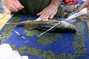
A walleye’s gills are watered after its stomach was stitched to hold a radio transmitter.

  • walleye's gills
  • Dr. Brian Weigel

The Wisconsin Department of Natural Resources is constantly doing research on the rivers and lakes in the state.

When you consider the thousands of lakes and thousands of miles of shoreline on the state’s rivers, the DNR has a never-ending job in keeping our waters clean — free of pollutants, protecting our resources and providing good fishing opportunities to the million and a half anglers who purchase resident and non-resident licenses.

Every spring, I go on to area lakes with DNR technicians as they electro-fish and fyke net fish on the Madison Chain of Lakes. The Madison lakes are regularly netted and shocked every five years for information and data on each lakes fishery and what is planned for the future in stocking and fish species.

For example, some of the research is the stocking of the Leech Lake muskie strain and the Wisconsin or Thompson muskie strain in local lakes to see which muskie does better in our waters and what muskie strain stocking is better economically. Much of the research being done will not produce results for years with the relatively slow growth of the muskie.

Recently, I happened to be up near the Prairie du Sac Dam on the Wisconsin River doing some wading for smallmouth bass. Near the VFW boating landing, I ran into Dr. Brian Weigel, a DNR fisheries researcher from the DNR Science Services Department, and Kurt Welke, DNR fish biologist and manager.

They were on the Wisconsin River researching the temperature preference of walleyes because the river’s temperature is now near the thermal preference threshold for walleyes. Many scientists and researchers predict that climate change will bring warmer water to the Upper Midwest, which may impact what fish species will inhabit and survive.

Conditions for fish — and walleyes in particular along with their close cousin the sauger — could be difficult in the future with an increase in the river’s water temperature which is predicted to be above the fish’s comfort zone. The researchers want to know where the walleyes are going in the warmer water of summer.

The day I ran into the DNR, they had two boats with fisheries technicians and grad students electro-fishing the waters below the dam for walleyes.

The electro-fished walleyes were put into a tank and revived from the shocking. Then, Weigel and Welke would cut a slit with a scalpel along the walleye’s stomach and insert a transmitter into the abdominal cavity.

The transmitters are about the size of an AAA battery. The cut was then stitched with monofilament line and patted down with iodine to prevent infection. The walleyes were then put into a “holding tank” which had a water re-circulator to keep the fish alive and give them time to recover before being released back into the Wisconsin River.

Weigel and Welke wanted to get 25 to 30 fish near the dam for their study. They seemed to be reaching their walleye quota.

The radio transmitters that are put into the fish will show where they are “hanging out” during the warmer months of the year. Walleyes have to be at least 16 inches long and preferably longer for the transmitters — which along with the software will allow Weigel to record data for two years. The transmitters are turned off during the winter.

There may be things done in the future to enhance the walleye’s survival such as improving fish habitat and changing the river’s water flow. The Wisconsin River fishery is a valuable and very vulnerable resource which deserves all the protection and help that it needs to provide fishing and recreational activities to all.

The trees and soil along the river’s banks are falling into the river at an alarming rate. The river seems to change every year with deeper areas getting filled in with sand and silt. Once one gets past the Highway 12 Bridge at Sauk City, it is difficult to find water deeper than 10 feet. The only really deep water is directly below the dam in the “scour” hole created from high water in the spring.

Weigel and his crew also electro-fished the Lower Wisconsin River from the Highway Y boat landing to Arena and only “caught” eight fish. There seemed to be many more walleyes in the immediate area below the Prairie Dam the previous day. This may be because the fish hadn’t migrated downriver yet, the larger females were still recovering from spawning, the fish were staying near the dam because of the deep water, or the fish were gorging on forage fish.

The DNR is trying to answer these and many more questions if we are going to continue to have a walleye fishery on the Wisconsin River. But, the real question is, where do walleyes go in warmer water?

Maybe they’ll go to the Mississippi River or do they cease to exist in the warmer river?

Only time will tell, but at least the DNR is pursuing the questions.

Contact Gary Engberg, a freelance outdoors writer, at gengberg@chorus.net, call 608-795-4208 or visit his website at http://www.garyengbergoutdoors.com.

Read more: http://host.madison.com/sports/recreation/outdoors/article_62553aee-a1fa-11e0-8731-001cc4c002e0.html#ixzz1REUuneDT

U.S. Fish and Wildlife Service announces $930,000 for wetlands and wildlife habitat under Great Lakes Restoration Initiative

See the dozens of unique artificial fish habitat models, fish attractors and fish cover used at fishiding.com, the industry leader and only science based, man made and artificial fish habitat, proven to provide all fish with cover they prefer to prosper.

U.S. Fish and Wildlife Service Midwest Regional Director Tom Melius, and Northeast Regional Director Marvin Moriarty, jointly announced today the approval of $930,000 for grants aimed at protecting, restoring, and/or enhancing 791 acres of wetlands and wildlife habitat in Michigan, New York, Ohio, and Pennsylvania under the Great Lakes Restoration Initiative (GLRI), Joint Venture Habitat Protection and Restoration Program.
Projects awarded funding include:

MICHIGAN
The Nature Conservancy was granted $150,000 for the Building a Protected Mosaic at Grass Bay project that will protect 41 acres of open dune/sand beach, wooded dune and swale, mixed northern hardwoods, and conifer swamps on or near the shoreline of Lake Huron. This area is of high importance to migratory waterfowl, shorebirds, and landbirds, including priority species such as Blue-winged Teal, Black-throated Blue Warbler, and Canada Warbler and also supports populations of three federally-listed plants. Protection of these two key tracts will facilitate better management of a larger high-quality complex of natural communities, and will also help land managers better protect sensitive intermittent wetlands from unauthorized off-road vehicle use and trespass.

Ducks Unlimited was granted $208,000 for the Maple River State Game Area Enhancement Project. This project will enhance344 acres of existing wetland habitat at the Maple River State Game Area in central Michigan, a 9000-acre wetland complex – the largest contiguous state-managed wetland complex in mid-Michigan. Project partners will remove outdated water control infrastructure and install a new pump and water control structure, which will not only enhance existing habitat for priority birds such as King Rail, Black Tern, and Black-crowned Night-Heron, but will also help combat the spread of invasive plants such as phragmites and purple loosestrife.

The Southwestern Michigan Land Conservancy was granted $250,000 for the Southeast Lake Michigan Riparian, Riverine, and Upland Habitats Protection/Restoration Project that will protect 120 acres of a diverse mix of habitats including upland and bottomland forest, wet meadow, and emergent marsh, including approximately two miles of frontage along the Black River, approximately two miles from Lake Michigan. The parcel supports populations of several priority breeding birds including Cerulean Warbler, Wood Duck, and American Woodcock, and recent surveys identified over 300 species of native plants on the property. In addition to protection of the parcel, project funds will also contribute to ecological restoration on site, via the removal of invasive species and stream bank restoration.

OHIO
The Cleveland Museum of Natural History was granted $61,250 for the Geneva Swamp Protection Project. This project will protect 50 acres of high-quality wetlands in northeastern Ohio. This expansive wetland system in the Lake Erie Lake Plain harbors populations of the state-threatened spotted turtle as well as several state-threatened plants and also supports an exceptional diversity of breeding and migratory birds. This parcel will contribute to a larger complex of recently protected areas, and will enable project partners to better protect and restore the unique natural communities and priority breeding birds present in the project area.

PENNSYLVANIA
Ducks Unlimited was granted $101,858 for the Presque Isle State Park Coastal Habitat Restoration. Presque Isle State Park is one of the most important migratory stopover areas in North America.  Its’ 3,200 acres provides a large area of wetlands and undeveloped shoreline (e.g., beach dunes and shrubs) that maintains high habitat quality for waterfowl, waterbirds and shorebirds.  The park contains the best remaining complex of sand dunes, sand barrens, emergent wetlands, and open-water lagoons along the U.S. shoreline of Lake Erie.  This project is part of a comprehensive, long-term, multimillion-dollar, collaborative effort between state agencies, non-governmental organizations, educational institutions, and local volunteers to enhance and restore unique natural communities located on the Lake Erie shoreline of northwestern Pennsylvania.  This grant will enable invasive species removal efforts on 201 acres, including aerial herbicide applications and a Menzi flail mower attachment.

NEW YORK
The Buffalo Audubon Society was granted $160,031 for the Avian Habitat Restoration at Joe Davis State Park project. Along the Niagara River shoreline, Joseph Davis State Park (JDSP) is a designated state Bird Conservation Area and Globally Important Bird Area (IBA).  In a largely industrial landscape, the 320 acre JDSP stands out as a relatively large, relatively undeveloped open space along the Niagara River corridor between Lakes Erie and Ontario.  The JDSP provides critical breeding habitat for many of high priority bird species.  It also provides important stopover habitat for migrating birds along this major migratory corridor.  Although more than 150 acres of shrub habitat was formerly present on JDSP, nearly half of this acreage has been degraded in the last decade through establishment by invasive species and natural succession.  This project will restore at least 35 acres of highly productive habitat for native pollinators and breeding and migrating birds.

The grants were awarded under the Great Lakes Watershed Habitat and Species Restoration Initiative Grants Programs administered by the U.S. Fish and Wildlife Service, a Department of the Interior agency. The grants were funded by the President’s 2011 Budget which provided $300 million for the Environmental Protection Agency –led, interagency Great Lakes Restoration Initiative. A portion of those funds were provided to the Upper Mississippi/Great Lakes and Atlantic Coast Joint Ventures for priority bird habitat conservation projects.

Passed in 2010, GLRI provides matching grants to organizations to restore and protect habitats for the protection and conservation of native Great Lakes fish and wildlife populations.

For more information on the U.S. Fish and Wildlife Service’s Great Lakes Restoration Initiative projects, please visithttp://www.fws.gov/GLRI/.

The mission of the U.S. Fish and Wildlife Service is working with others to conserve, protect, and enhance fish, wildlife, plants, and their habitats for the continuing benefit of the American people. We are both a leader and trusted partner in fish and wildlife conservation, known for our scientific excellence, stewardship of lands and natural resources, dedicated professionals, and commitment to public service. For more information on our work and the people who make it happen, visit www.fws.gov.

Qualicum Beach negotiates a water buy-in

Arrowsmithdam.jpg

The Arrowsmith Water Service draws its supply from this dam on the Englishman RIver.

News file photo
By Auren Ruvinsky – Parksville Qualicum Beach News
Published: June 28, 2011 9:00 AM
Updated: June 28, 2011 9:07 AM

After a long tough process the Arrowsmith Water Service settled important governance and funding issues at their latest meeting.

At their June 23 meeting, the City of Parksville, Regional District of Nanaimo and Town of Qualicum Beach signed the new joint venture agreement settling issues sparked by Qualicum Beach being reluctant to share the cost of the imminent capital infrastructure work.

The new agreement gives the partners weighted voting power depending on their level of ownership, giving Parksville three votes, the RDN two, and one to Qualicum Beach.

The ownership proportions remain the same, with Parksville at 63.9 per cent, the RDN owning 22.4 per cent and Qualicum Beach at 13.7 per cent, but Qualicum Beach will not contribute to the costs of the new Englishman River intake and water treatment facility in Parksville, with the option to buy its way in later.

When the town needs the water, they will be able to buy their way in by paying their portion of the original construction costs, plus the Consumer Price Index inflation costs.

“I’d like to compliment the staff,” said AWS board representative from Parksville Marc Lefebvre. “This is a demonstration of what we can do when we work together. On behalf of Parksville I would rather have had Qualicum Beach participate in the costs, but it’s understandable.”

A recent report confirmed that by 2050 Parksville — which already uses river water in the peak summer periods — will take 54 per cent of its bulk water from the river.

Nanoose Bay will need 22 per cent, French Creek will need 18 per cent and Qualicum Beach will only need six per cent.

“We’ve had a good relationship and its good we will be going forward,” said Qualicum Beach representative Barry Avis. “There’s no question of our support for the Arrowsmith Water Service.”

Parksville acting mayor Chris Burger said the agreement provides stability moving forward and allows them to approach senior levels of government for funding with a united front.

RDN chair and AWS board member Joe Stanhope called it a milestone agreement and said it was not only good for the residents of Oceanside, but pointed out fish habitat comes first in the language, stressing the importance of considering the wildlife and environment in the process.

The updated agreement, established in 1996 and last updated in 2006, includes a new provision giving right of first refusal of any assets to the partners to keep it in local government ownership.

Carol Mason, RDN chief administrative officer, explained there were a number of issues with the old agreement, including out of date language.

The new agreement makes it clear the AWS management board can’t supersede local municipal decisions, better reflects local government structures and includes clearer rules for new or withdrawing partners and the disposition of the entire venture to ensure protecting public ownership, she said.

Meanwhile the public and board heard an update on the intake and treatment facility progress, still in the early planning stages.

Staff presented an implementation schedule laying out many parallel tracks of study, planning, exploring funding options and public information, with open houses in 2013 leading to a public referendum in 2014 or 2015, hoping to begin construction in 2015.

The recent report estimated at a conceptual level that the first stage will cost $37 million in 2010 dollars, with a total cost of $52 million over the next 40 years.

The new river intake and treatment facility are required for Parksville and parts of the RDN to meet their projected water needs in the near future. A recent Qualicum Beach report found they will not likely need to supplement their existing city water wells.

The board heard that they have met all the conditions to purchase the needed land for the facility along the river behind the city works yard in the industrial park and hope to close at the end of June.

There is a lot of information on the service’s website at www.arrowsmithwaterservice.ca, which they intend to keep up to date as a key part of their communication strategy.

See the dozens of unique artificial fish habitat models, fish attractors and fish cover used at fishiding.com, the industry leader and only science based, man made and artificial fish habitat, proven to provide all fish with cover they prefer to prosper.

writer@pqbnews.com

Alewives to be a topic of discussion at meeting

Published Tuesday June 28th, 2011

Speak Up

ST. STEPHEN – Alewives will very likely come up at a public meeting Wednesday night in St. Stephen.

If the Canada/United States International Joint Commission does not raise the topic, conservation and environmental organizations will.

The commission and its St. Croix Board Watershed Board will hold their annual public meeting at the Milltown Legion Hall at 444 Milltown Blvd. at 7 p.m.

The commission, founded in 1909, administers the Canada/United States Border Waters Treaty.

The agenda for the meeting Wednesday includes a presentation on smallmouth bass habitat in Spednic Lake at the head of the river, above the dam from St. Croix to Vanceboro, Maine.

Alewives, also called gaspereau, were the sole topic of discussion at last year’s public meeting in Princeton, Maine.

The commission has a draft plan to reopen the upper reaches of the St. Croix River to this native anadromous fish. Sport fishing interests in Maine fear that opening fishways to alewives would imperil the commercially important smallmouth bass introduced in the 19th century.

Maine still blocks the river to alewives above Grand Falls in defiance of a Canada/United States treaty.

Opening the Grand Falls fishway would allow the alewives to return to spawning grounds up the main branch of the river to St. Croix/Vanceboro, and up the West Branch to the Grand Lake Stream dam.

This could allow the alewives to increase to millions of fish rather than the tens of thousands counted in recent years. Alewives, born in fresh water, go to sea where they feed before returning to their home rivers to spawn.

Aside from their use as lobster bait, they provide feed for many water and land creatures. People do eat them, but they are not considered a delicacy.

As of June 20, the St. Croix International Waterway Commission reported a total of 25,125 alewives coming through the Milltown fishway research trap.

See the dozens of unique artificial fish habitat models, fish attractors and fish cover used at fishiding.com, the industry leader and only science based, man made and artificial fish habitat, proven to provide all fish with cover they prefer to prosper.

Scroll to Top