StructureSpot

proposed suit over fish habitat………

Official: ‘Misperception’ to blame for proposed suit over fish habitat

1:41 AM, Jul. 9, 2011  |

RIVERSIDE — A dozen Inland Empire water agencies poised to wage a legal battle against the Obama administration over its decision to expand the habitat of an endangered fish may be laboring under a “misperception” about the impact of the edict, a federal official said Friday.

The Riverside County Flood Control & Water Conservation District, Riverside Public Utilities and 10 other agencies are threatening to file a lawsuit to stop the U.S. Fish & Wildlife Service from enlarging protected space for the Santa Ana Sucker.

According to the plaintiffs, a December ruling by federal officials would effectively shut off 125,800-acre-feet of water, depriving the region of one-third of its current fresh water stocks.

Representatives from the water agencies will be taking their complaints to members of the California congressional delegation on Monday.

According to USFWS spokeswoman Jane Hendron, the utilities are making a federal case out of a dispute based largely on superficialities, not actual harm.

Hendron said the “critical habitat” designation behind the controversy will not hinder use of water supplies.

“There’s a misperception about critical habitat. People don’t realize that it does not trigger any specific action,” Hendron told City News Service.

She said the designation provides an “additional layer of review” before developers or municipalities can proceed with making any changes along waterways that have been recognized as critical to a threatened species.

In the case of the Santa Ana Sucker, the U.S. Department of Interior’s “Final Rule” dictates that any planned modifications to the area encompassing the river’s headwaters in the San Bernardino Mountains be cleared by the USFWS or the U.S. Army Corps of Engineers.

The Sucker’s habitat has been further degraded by construction of the Seven Oaks Dam, which has “significantly altered the natural hydrological regime,” Hendron said. “This does affect habitat downstream. What you do upstream can affect the downstream environment,” she said. According to the water agencies, efforts to preserve the Sucker have been successful, and the federal ruling threatens to destabilize the region. Federal officials issued findings in 2005 that concluded state and local conservation efforts to protect the Sucker were paying off. However, last year, USFWS representatives reversed course. Citing a 2004 study, they declared gravel and cobble substrate required for the endangered fish’s survival had been drastically reduced since dam construction. Federal officials want higher volumes of water released from the dam to uncover substrate, which promotes algae growth and spawning grounds. Last month, a fact-finding committee composed of local and federal officials determined that stronger flows produced by releasing dam water often had the opposite effect of what was intended, creating high levels of sediment and murky underwater conditions — negatives for the fish. Local water agencies argue that the amount of water to be restricted for the benefit of the amphibian could be used to replenish regional water stocks and help reduce the region’s dependence on water imports from the San Joaquin Delta, which is already under a federal pumping limit to protect the endangered Delta Smelt.

See the dozens of unique artificial fish habitat models, fish attractors and fish cover used at fishiding.com, the industry leader and only science based, man made and artificial fish habitat, proven to provide all fish with cover they prefer to prosper.

Teamwork helps rebuild Dairyland Flowage’s fish habitat

Dairyland FlowageJoe Knight

Dairyland Flowage

Students from Flambeau, Bruce and Ladysmith high schools hauled trees out to deeper water Tuesday in the Dairyland Flowage.

Related Video

Posted: Thursday, July 7, 2011 11:55 pm | Updated: 7:45 am, Fri Jul 8, 2011.

By Joe Knight Leader-Telegram staff |

LADYSMITH – The day was warm, the water temperatures hovering between 89 and 90 degrees, making it more comfortable for students from three Rusk County high schools who spent the morning up to their necks in water.

Some students in a boat mixed cement to anchor individual spruce trees to the bottom of the Dairyland Flowage while others swam or waded with trees they positioned at the sides of submerged rock piles. The rocks had been dropped through the ice along the shore during the winter.

The position of the rocks had been marked with a GPS. Those coordinates, plus some searching by students, helped locate the piles this summer. The individual trees with cement foundations would be placed between the rock piles to provide additional cover.

The idea is to provide a diversity of habitat to give minnows and small fish a place to live, which in turn will provide food for bigger fish, said Jerry Carow of the Rusk County Wildlife Restoration Association, the nonprofit group coordinating the project.

The work began three years ago when Dairyland Power Cooperative drew down the reservoir to repair a dam. The association and Dairyland Power took the opportunity to haul rocks and trees onto the dry lake bed to create aquatic habitat.

When the power company refilled the lake, they saw no reason to stop creating habitat. They just had to change their methods, Carow said. Because Dairyland Power has a five-year permit from the state Department of Natural Resources to create habitat in the lake, they decided to keep going with that work.

Since the project began three years ago, the power company has brought in about 6,400 cubic yards of rock – the equivalent of a four-mile stretch of rock three feet wide and three feet high, Carow said.

So far the project has involved the installation of about 2,000 trees. Another 500 to 1,000 could be added, Carow said.

The project involves students from Flambeau, Bruce and Ladysmith high schools during summer months. During the rest of the year, prisoners from Flambeau Correctional Center provide the labor.

Fat fish

The habitat work appears to be helping fish in the flowage, said John Thiel, senior environmental biologist with Dairyland Power.

Natural reproduction of walleyes always has been good on the flowage, an impoundment of the Flambeau River, but growth of the fish typically has been slow, he said. Now the walleyes are growing faster.

“We’ve had a 2-inch increase in the average size of walleyes we’ve collected,” Thiel said.

During the next few years, more walleyes should be moving into the legal size range, he said.

Black crappies have become more abundant and also are growing well, Thiel said. Bluegills are not abundant in the flowage but are more common now than they were, as are perch and smallmouth bass.

When the reservoir was created in the early 1950s, the power company removed trees logs and stumps along the shoreline. Officials at the time figured drifting wood might interfere with power generation.

“At the time they didn’t realize they were removing all the good fish habitat,” Thiel said. “What the lake really needs is shallow water fish habitat.”

The reservoir always has been home to big muskies, but the waterway is low on suckers, a favorite food of muskies. One potential problem was a perched road culvert on nearby Crooked Creek that may have been blocking upstream spawning movements of suckers and other fish in the spring. Officials lowered the culvert so fish could get upstream, and they plan to survey the creek later this summer to find evidence of spawning by suckers, Thiel said.

Regulations

Dairyland Power and the wildlife association had wanted to bring in heavy equipment and move some existing gravel on the reservoir’s bottom three years ago when the reservoir was drained, but the DNR nixed that idea because of mercury contamination in the sediment. The mercury came from paper plants upstream.

Thiel thought the project could have been completed without recirculating mercury in the system – Dairyland had done some testing of the sediments – but the power company lost that argument.

That decision caused Dairyland Power to change plans and downsize the reefs they wanted to build, but, with the help of the wildlife association and other community groups, fish habitat in the flowage is much improved, he said.

Summer jobs

This is the fourth summer that Charlie Coughenour, a student at Ladysmith High School, has done conservation work for the Rusk County Wildlife Restoration Association.

“It’s a lot of fun. It gives me something to do in the summer, plus I get paid,” said Coughenour, who will be a senior this fall.

Twenty-four high school students worked this summer on the project, which included fish habitat improvement, repairing erosion sites, building a nature trail and creating fishing access sites.

Students work for five weeks and earn $24 per day, plus one-half of a high school credit. The students are supervised by teachers and four college interns.

Coughenour said he has learned some construction skills in the program and it’s also influenced his career choice. He plans to attend UW-Stevens Point and study environmental science.

Knight can be reached at 715-830-5835, 800-236-7077 or joe.knight@ecpc.com.

See the dozens of unique artificial fish habitat models, fish attractors and fish cover used at fishiding.com, the industry leader and only science based, man made and artificial fish habitat, proven to provide all fish with cover they prefer to prosper.

Give managed forestry credit for the fish habitat at Battle Creek

Another View: Give managed forestry credit for the fish habitat at Battle Creek

By David A. Bischel
Published: Sunday, Jun. 26, 2011 – 12:00 am | Page 3E

Re “Governor needs to keep pledge at Battle Creek” (Editorial, June 21):

The Bee’s editorial board took what should have been a positive story about removing dams and instead pandered to unfounded fears to suggest that forestry harms fish-recovery efforts, even though forestry is included in watershed restoration precisely to benefit salmon. Not only is forest management not an obstacle, forestry helps fund restoration that must otherwise be paid for by taxpayers or wouldn’t happen at all.

At issue is the Battle Creek Salmon and Steelhead Restoration project, which according to the California Department of Fish and Game will “re-establish access to 42 miles of premier spawning and rearing habitat for spring- and fall-run chinook salmon and steelhead.” This ideal fish habitat has been created by decades of active forest management in the watershed, including clear-cutting that some want to ban.

Science shows that carefully managed forestry operations can create ideal spawning habitat, conserve water resources and protect watersheds against high-intensity wildfire. California clear-cuts create small openings, are replanted with native species by law and establish biologically diverse forests of all ages on the landscape.

Humboldt State University’s John-Pascall Berrill notes that “clear-cutting is a process that cannot be judged in a single moment in time” and that the “water-quality impacts of clear-cutting in California are likely within the range of natural disturbance.” Site-specific research from Battle Creek shows virtually no negative impacts on water quality from harvest activities.

Rather than note that forest management has established ideal salmon habitat at Battle Creek, The Bee assumes that restoration will not be managed carefully and that having two agencies work to conserve water quality is a conflict of missions.

The Bee’s editorial went on to encourage Gov. Jerry Brown to adopt a budget that would impose new harvest-plan review fees. We think this could add about $40,000 per plan to fees already roughly 10 times higher than those in neighboring Oregon and Washington. This short-sighted suggestion fails to recognize that additional fees would cripple businesses already reeling from the highest permitting costs in the nation, cost jobs in rural communities suffering disproportionally high unemployment, and dismantle the infrastructure absolutely essential to addressing California’s wildfire crisis.

Harvest-plan review costs have nearly doubled since 1997 despite an 80 percent decline in harvest operations. Imposing fees on forest landowners will not make the process more efficient but could eliminate the forestry sector in California, bankrupt counties struggling to provide social services and kill the rural way of life.

See the dozens of unique artificial fish habitat models, fish attractors and fish cover used at fishiding.com, the industry leader and only science based, man made and artificial fish habitat, proven to provide all fish with cover they prefer to prosper.

Read more: http://www.sacbee.com/2011/06/26/3726139/give-managed-forestry-credit-for.html#ixzz1RKWhIgBB

Yellow fish boost Langley environment

A Langley drain-marking program aims to educate people about their impact on fish habitat.

POSTMEDIA NETWORK INC. JULY 5, 2011
A Walnut Grove family marked storm drains together in the Yorkson Creek neighbourhood.

A Walnut Grove family marked storm drains together in the Yorkson Creek neighbourhood.

Photograph by: submitted, for Langley Advance

All drains lead to fish habitat.

It’s a widely misunderstood fact that Langley Environmental Partners Society (LEPS) wants to clear up for everyone.

In urban areas, storm drains on paved streets and parking lots collect rainwater runoff.

The runoff – containing sediments, animal waste, oil, swimming pool water, and toxic household or industrial compounds – all goes into storm drains. It does not go into the domestic sewage system.

Storm drains empty the untreated runoff into nearby waterways, impacting fish habitat.

Just one drop of motor oil can make 50 litres of water unlivable for water species.

LEPS’s 4th annual Storm Drain Marking Challenge is running through July.

Participants are asked to mark storm drains with the iconic yellow fish that alerts people that the drains lead to fish habitat.

Prizes for the most drains marked will be awarded.

To find out more and to collect your storm drain marking materials contact Lina Azeez at lazeez@tol.ca or 604-532-3517. www.leps.bc.ca/events

Langley Environmental Partners Society (LEPS) is a non-profit, partnership-driven organization, founded in 1993, to achieve the mission of “protecting and restoring the natural environment through education, cooperation and action.”

Read more:http://www.langleyadvance.com/Yellow+fish+boost+Langley+environment/5054070/story.html#ixzz1RKUUNWfa


See the dozens of unique artificial fish habitat models, fish attractors and fish cover used at fishiding.com, the industry leader and only science based, man made and artificial fish habitat, proven to provide all fish with cover they prefer to prosper.

Fish Habitat News

Action Plan News Williams Run, Pennsylvania
Williams Run, Pennsylvania
MONDAY, 09 NOVEMBER 2009 15:06
Williams Run is a tributary of South Sandy Creek in Venango County, PA.  Aquatic habitat in Williams Run has been severely damaged since coal mining activities produced acid mine drainage in the stream.Valerie Tarkowski (South Sandy Creek Watershed Association) surveys Algae growing near the headwaters of Williams RunWater conditions were degraded with a very low pH, no alkalinity, and both iron and aluminum contamination. This point-source pollution left the stream uninhabitable for brook trout and other aquatic life.  Williams Run is currently listed on the Pennsylvania Department of Environmental Protection’s 303d List of Impaired Streams.See the dozens of unique artificial fish habitat models, fish attractors and fish cover used at fishiding.com, the industry leader and only science based, man made and artificial fish habitat, proven to provide all fish with cover they prefer to prosper.

Williams Run represents waterways across the country, including lakes and reservoirs, that are improving through the conservation efforts of the National Fish Habitat Action Plan—a bold initiative to reverse persistent declines in aquatic habitat.

Thanks to the combined actions of concerned community groups, nonprofit organizations, and state and federal agencies, these waters are being improved by planting stream-side vegetation, removing impediments blocking fish habitat and protecting waterways from the effects of industrial processes, specifically acid mine drainage (AMD).

With funding provided through the Eastern Brook Trout Joint Venture, the South Sandy Creek Watershed Association (SSCWA) is working with a host of public and private partners to bring Williams Run back to life. Construction of a passive limestone bed will restore water quality and allow aquatic species, such as the brook trout, to naturally return to Williams Run.  Additional funding is provided by the Office of Surface Mining and the National Fish and Wildlife Foundation.

This restoration is expected to provide a unique remote trout fishing opportunity on public lands managed by the Pennsylvania Game Commission.

In recognition of the partnership efforts and potential to significantly improve aquatic habitat, Williams Run has been selected from among projects across all 50 states as one of the National Fish Habitat Action Plan’s “10 Waters to Watch” for 2008.

Local organizers of the restoration are thrilled with the national recognition of their efforts.  “It’s been a long fours years to get from the founding of our organization to this point, and there were efforts by other groups before ours, said Larry Wheeler, president of the SSCWA, but you can really see the results on the ground now.”

Williams Run tributaries are already home to wild brook trout populations, and restoration of the Williams Run mainstem will add another 9 miles of healthy stream habitat. Williams Run flows into South Sandy Creek, Sandy Creek and the Allegheny River, all sustainable waterways for healthy fish populations.

Other project partners include private landowners, Mineral Township, and PA Senior Environmental Corps, as well as PA DEP’s Cambria County office of the Bureau of Abandoned Mine Reclamation and the Pennsylvania Fish & Boat Commission, both of which provided monitoring and technical assistance, and many others. Construction began this summer and is expected to be finished at the end of 2008, with immediate benefits to water quality in Williams Run.

Williams Run is located in southwest Venango County, mainly on State Game Lands 39.

View Williams Run Project Profile (PDF)

Federal officials deem waters environmental success story

Published: Saturday, July 02, 2011

By RICHARD PAYERCHIN

rpayerchin@MorningJournal.com

LORAIN — Federal officials agreed the Black River is an environmental success story with more chapters to come.

Lorain officials hosted a reception and river tour for local partner groups and officials from the federal National Oceanic and Atmospheric Administration, which contributed $1.69 million for fish habitat restoration in the river. The tour also was an introductory event for the holiday weekend, which features Independence Day celebrations along with Port Fest and the inaugural Black River Kayak-a-thon river race.

Staff from NOAA and the Great Lakes Commission praised the city’s efforts to remove slag piled along the river’s shore and restore a natural flood plain behind Lorain’s steel mill.

Restoring the river’s ecology also will help Lorain’s economy as more people venture onto the Black River to boat, sail, paddle and fish, said John Iliff, regional supervisor for the Great Lakes Restoration Program of NOAA.

“This project absolutely stood out,” Iliff said, as Lorain competed with 60 other projects for limited federal funding.

It was his first trip to Lorain to see the work paid for with federal money.

“The Black River, ecologically it’s sound,” Iliff said. “The Black River itself is beautiful. It has a lot of hidden beauty that’s not visible as you’re just coming through the highway corridors and the bridge corridors. The Kayak-a-thon is going to start to really open people’s eyes to the recreational opportunity the Black River is. I think there’s great potential both ecologically and economically, recreationally for the folks who live here.”

The project likely will become an example that Great Lakes advocates use when talking to Congressional leaders about money for environmental restoration, said Matt Doss, policy director for the Great Lakes Commission in Ann Arbor, Mich.

The Black River is a prime example of remediation to restoration — cleaning up problem areas and replacing the bad items with good ones, Doss said.

“As I went up the river today, it’s beautiful,” Doss said. “You saw kayakers and fishermen and I’ve dozens of pictures of herons and it’s just beautiful. I’m really impressed.”

The day included river tours for local, state and federal officials aboard the Lorain Port Authority boats.

The vessels ventured upriver to rendezvous with researchers from the Midwest Biodiversity Institute, who used electrical current to stun fish in the river, then count them.

As the vessels moored alongside each other, Roger Thoma stole the show as he picked up fish the crew had caught. Lorain Utilities Director Corey Timko, who spoke at the reception, spoke of his experience studying with Thoma and credited his vision for inspiring efforts toward Lorain’s Black River restoration.

The catch included largemouth bass, bluegill, pumpkinseed sunfish, rock bass, freshwater drum, golden shiner, bluntnose minnow, gizzard shad and channel catfish. He explained to the passengers each species, including why they are important in the environment and how they taste when cooked. The crowd chuckled as several fish flopped out of Thoma’s hand and into the holding tank.

The restoration project includes piled stones called “fish shelves” design to create habitat where plant will grow and fish will rest, eat and spawn.

The Black River already has plants growing along shore but needs more vegetation in the water to improve the river’s ecological health, Thoma said. The minnows like vegetated areas and other fish, such as the bluegill and largemouth bass, go there to feed, he said.

“Again, we’re back to that issue of vegetation and getting that vegetation going up here in the Black River so that the fish will follow,” Thoma said. “There’s a lot more to vegetation than just the fish.”

The Black River looked cloudy and green because algae was growing on nutrients in the river, Thoma said.

“If we had enough vegetation in the river, the vegetation would suck up those nutrients and the algae wouldn’t grow as abundantly and then the water would be clearer,” Thoma said.

The river trip concluded with a view of three bald eagles soaring in circles over the shore. The birds were distant, but their white tales clearly were visible when the sun shone on them.

“It looks beautiful, it looks great,” said Vickie Thoma, a Lorain native and wife of Roger Thoma. “How majestic. What a great day.”

Fish Habitat Program

Fish Habitat Program

Funding assistance is available to County Conservation Boards for land acquisition and development of fish habitat. Up to 90 percent of costs may be reimbursed under this program. Land must be under the direct control of the county to be eligible for assistance. This program is unique in that the applications are sent to the County Conservation Board Districts for review and selection of projects.

Available funds are divided equally between the six county districts. Approximately $70,000 will be available this grant cycle.

Eligible development activates include:

  • Physical placement of fish habitats in ponds, lakes, pits and streams
  • Armoring of pond, lake pit and stream shores.
  • Construction of aeration systems
  • Dredging of ponds or lakes
  • Construction of sediment retaining basins
  • Repair of lake dams and outlets
  • Manipulation of fish populations and aquatic vegetation
  • Removal of dams
  • Construction of fish ladders
  • Construction of fish barriers
  • Construction of rock-faced jetties

Acquisition projects are eligible when the land is used for fish habitat development purposes. Project activities eligible for funding include:

  • Land acquisition for pond and lake construction
  • Land acquisition for fishable streams, ponds and lakes
  • Land acquisition for watershed protection

Applications are due on the last working day in November of each year. The applicant should submit seven copies of the grant application to the review and selection committee chairperson within the appropriate County Conservation Board District. The committee will review the applications in January and then forward the results to the DNR.

The Minority Impact Statement Form is required to be filled out and sent with your application:
Minority Impact Statement Form

Fish Habitat Program Grant Application

For more information or to have an application mailed to you please contact Mimi Habhab at 515-281-5034 or by e-mail at Mimi.Habhab@dnr.iowa.gov.


See the dozens of unique artificial fish habitat models, fish attractors and fish cover used at fishiding.com, the industry leader and only science based, man made and artificial fish habitat, proven to provide all fish with cover they prefer to prosper.

The Catfish Cradle

The catfish’s cradle

Species thrives under near-perfect conditions found in Lake Houston

By SHANNON TOMPKINS

June 30, 2011, 10:59AM

photo
Shannon Tompkins

When fishing Lake Houston’s thriving catfish fishery, guide Walter Pratt and clients regulary land blue cats.

Walter Pratt faced a problem any angler would be happy to have.

Standing at the edge of the water on an island in Lake Houston earlier this week, the 50-year-old Splendora resident was smiling as he held a fishing rod and fought what turned out to be a 3-pound blue catfish.

But as the catfish wallowed on the surface a few yards off the bank, the tip of Pratt’s second rod, propped on a nearby holder, began nodding with the telltale signal a fish was gobbling the chunk of threadfin shad hiding a hook.

What to do?

Pratt hurriedly battled the blue cat to the bank, lifted it far enough onto the sand that it couldn’t easily flop back into the lake, dropped that rod, grabbed the other, set the hook and was fast to another fish.

He turned, grinning as he reeled in what proved to be a 14-inch channel catfish.

“Now you see why I say Lake Houston is the best catfish lake I’ve ever fished,” Pratt said.

He and Lake Houston’s catfish had already made a strong argument to that effect.

Pratt, whose Walt’s Guide Service specializes in rod-and-reel catfishing trips on the 12,000-acre reservoir on the San Jacinto River in far-northeast Houston, picked up my fishing partner and me at Lake Houston Marina at dawn. We carefully motored up the lake, dodging stumps and sandbars and islands uncovered by the reservoir’s shrinking water level until easing ashore on a heavily timbered island where we set up chairs and ice chests on a shady, sandy strip of beach.

We baited hooks with chunks of fresh shad, heaved them into the lake, sat down and settled into chairs to wait. But we didn’t have time to get comfortable.

Almost immediately, we began catching catfish. Lots of catfish. Channel cats. Blue cats. The smallest we landed were at least an inch over the 12-inch minimum for blue and channel cats. The largest was a 28-inch blue that weighed 8 pounds. And we had a handful of 3-5-pounders.

It seemed as though the flat between the island and the old San Jacinto River channel was crawling with catfish.

“We always catch a good mess of fish,” the gregarious Pratt said. “I’ve fished for catfish all over Texas. I used to think Lake Livingston had the best catfishing — and it is good. But for numbers and average size, I haven’t found a better lake than Lake Houston.”

Numbers don’t lie

Empirical evidence supports Pratt’s anecdotal observations.

“Lake Houston has really strong populations of blue and channel catfish,” said Mark Webb, district biologist for the Texas Parks and Wildlife Department’s inland fisheries division. “And the fish are fat and healthy.”

Results of TPWD gill net surveys of Lake Houston earlier this year produced averages of 40 blue cats and 24 channel cats per “net night,” Webb said.

“That’s huge,” he said, adding the fish taken in the samplings showed a wide range of sizes of catfish, which indicates strong recruitment of young fish and good numbers of older, larger fish.

“Lake Houston’s catfish fishery is really underutilized,” Webb said. “It’s by far the strongest fishery in the lake, but doesn’t get that much pressure.”

That’s in large part a function of Lake Houston’s physical character and reputation.

The lake, built in 1954 as a water source for the City of Houston, is mostly an open-water reservoir with very little shallow-water habitat (willows, aquatic vegetation or other “structures”) conductive to largemouth bass, sunfish and crappie.

Considerable bulkheading along the shoreline by lakeside property owners hurts shallow-water aquatic habitat. But it’s the lake’s often muddy water, caused by runoff from sand and gravel operations along the San Jacinto River upstream from the lake, that really limits shallow-water habitat needed by largemouths. All that muddy runoff causes siltation and limits the amount of sunlight able to penetrate the water.

“You just don’t have the littoral habitat to support a premier largemouth bass fishery,” Webb said.

But Lake Houston does provide just the kind of habitat in which catfish can thrive, he said. The water is rich in nutrients that support a healthy population of threadfin and gizzard shad – primary forage for blue catfish.

Channel cats, which focus primarily on crawfish, aquatic insects and other benthic creatures, also find plenty of food in Lake Houston.

“Lake Houston has a good, strong forage base,” Webb said. “You see that in the body condition of the catfish. They are extremely healthy.”

So is the lake’s water.

“The lake’s water quality is excellent; it’s just muddy,” Webb said.

Add low predation on young catfish (largemouth bass are big predators on small catfish, but Lake Houston’s bass population is modest at best), and you have the ingredients for a booming catfish fishery.

Somewhat surprisingly, given that catfish are the second most-popular target species among the state’s 2 million or so freshwater anglers and the lake sits within 50 miles of nearly 5 million people, Lake Houston’s catfish fishery is relatively ignored.

TPWD surveys of anglers fishing the lake indicated 43 percent of them were targeting crappie, 28 percent were after largemouth bass, and only 15 percent focused on catfish.

Also, most of the fishing pressure on Lake Houston is concentrated in Luce’s Bayou and adjacent waters on the northeast side of the lake – not surprising, as the Luce’s Bayou area holds almost all of the best bass/crappie habitat in the reservoir.

That leaves the rest of the lake to people like Pratt, who have discovered just how good the lake’s catfishing can be.

“I can’t remember a day when we didn’t catch a bunch of fish,” Pratt said of his seven years targeting Lake Houston’s catfish.

A typical trip produces a mix of channel and blue cats, he said. And it’s traditional, laid-back catfishing – from the bank in chairs set on a shady, sandy shoreline or, when the lake level is up and he can use a larger boat, from an anchored pontoon boat.

Best-kept secret

Most of the catfish Pratt’s clients land are well over the 12-inch minimum. Channel cats, which don’t grow as large as blues, average 13-17 inches. Blues average 15-25 inches, with occasional fish weighing 10 pounds or more. (The heaviest LakeHouston catfish he’s caught on rod-and-reel was a 44-pound flathead, and the heaviest blue was a 36-pounder caught on a jug line.)

Experienced anglers commonly land 25-fish aggregate limits of blues and channels, Pratt said. And they almost always have the fishing and the wildlife-rich islands to themselves.

“We see deer and pelicans and roseate spoonbills and even bald eagles,” Pratt said. “But we hardly ever see any other people catfishing.

“They don’t know what they’re missing.”

Read more: http://www.chron.com/disp/story.mpl/outdoors/tompkins/7633251.html#ixzz1REWXEtJL

Fish habitat report reveals mixed outlook for Michigan

Our debut story this week looks at the most recent “Waters to Watch” list from the National Fish Habitat Action Plan, a nationwide collaboration between government agencies, grassroots groups and others to restore and improve fish habitat.

Just a few days before issuing the list, the Action Plan released a report (PDF) outlining the status of fish habitat in the nation’s rivers and estuaries.

“There hasn’t been a report done at this scale nationally,” said Ryan Roberts, communications coordinator for the Action Plan.

Nationwide, nearly 40 percent of freshwater fish species are “at risk or vulnerable to extinction,” according to the report, with habitat loss the biggest cause of past extinctions.

Twenty-seven percent of stream miles in the lower 48 are at high or very high risk of habitat degradation, and 29 percent are at moderate risk, the report says.  The figures are based on risk factors like livestock grazing and agriculture, urban development, mining and dams.

The outlook for Michigan’s rivers is mixed, according to an interactive map that accompanies the report.

At its lowest resolution, the map reveals the picture you might expect: There’s a big red patch indicating very high risk in the state’s southeast corner, and as you move north the threat level decreases, ending with a purple band across the Upper Peninsula denoting very low risk.

But when you use the finest scale, the map gets more complicated.  It shows some remote watersheds in the U.P. at very high risk for a range of reasons, and a handful of southeast Michigan streams are shown to be at low risk.

The report is limited in scope.  To make data collection manageable, the report leaves out lakes, reservoirs and marine areas.  Limited historical data led the Action Plan to also leave out a range of threats–including water withdrawals, animal feedlots, forestry and oil drilling–that are of particular interest in Michigan.

As part of its charter, the Action Plan is slated to update the report every five years.  Future reports will likely cover other water bodies and additional threats, Roberts said.

See the dozens of unique artificial fish habitat models, fish attractors and fish cover used at fishiding.com, the industry leader and only science based, man made and artificial fish habitat, proven to provide all fish with cover they prefer to prosper.

Outdoors: Research continues on Wisconsin River

  •  

GARY ENGBERG|For the State Journal | No Comments Posted | Posted: Tuesday, June 28, 2011 10:00 pm

 See the dozens of unique artificial fish habitat models, fish attractors and fish cover used at fishiding.com, the industry leader and only science based, man made and artificial fish habitat, proven to provide all fish with cover they prefer to prosper.

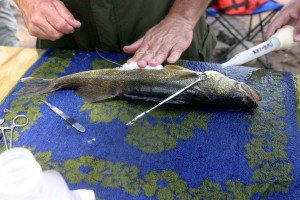
A walleye’s gills are watered after its stomach was stitched to hold a radio transmitter.

  • walleye's gills
  • Dr. Brian Weigel

The Wisconsin Department of Natural Resources is constantly doing research on the rivers and lakes in the state.

When you consider the thousands of lakes and thousands of miles of shoreline on the state’s rivers, the DNR has a never-ending job in keeping our waters clean — free of pollutants, protecting our resources and providing good fishing opportunities to the million and a half anglers who purchase resident and non-resident licenses.

Every spring, I go on to area lakes with DNR technicians as they electro-fish and fyke net fish on the Madison Chain of Lakes. The Madison lakes are regularly netted and shocked every five years for information and data on each lakes fishery and what is planned for the future in stocking and fish species.

For example, some of the research is the stocking of the Leech Lake muskie strain and the Wisconsin or Thompson muskie strain in local lakes to see which muskie does better in our waters and what muskie strain stocking is better economically. Much of the research being done will not produce results for years with the relatively slow growth of the muskie.

Recently, I happened to be up near the Prairie du Sac Dam on the Wisconsin River doing some wading for smallmouth bass. Near the VFW boating landing, I ran into Dr. Brian Weigel, a DNR fisheries researcher from the DNR Science Services Department, and Kurt Welke, DNR fish biologist and manager.

They were on the Wisconsin River researching the temperature preference of walleyes because the river’s temperature is now near the thermal preference threshold for walleyes. Many scientists and researchers predict that climate change will bring warmer water to the Upper Midwest, which may impact what fish species will inhabit and survive.

Conditions for fish — and walleyes in particular along with their close cousin the sauger — could be difficult in the future with an increase in the river’s water temperature which is predicted to be above the fish’s comfort zone. The researchers want to know where the walleyes are going in the warmer water of summer.

The day I ran into the DNR, they had two boats with fisheries technicians and grad students electro-fishing the waters below the dam for walleyes.

The electro-fished walleyes were put into a tank and revived from the shocking. Then, Weigel and Welke would cut a slit with a scalpel along the walleye’s stomach and insert a transmitter into the abdominal cavity.

The transmitters are about the size of an AAA battery. The cut was then stitched with monofilament line and patted down with iodine to prevent infection. The walleyes were then put into a “holding tank” which had a water re-circulator to keep the fish alive and give them time to recover before being released back into the Wisconsin River.

Weigel and Welke wanted to get 25 to 30 fish near the dam for their study. They seemed to be reaching their walleye quota.

The radio transmitters that are put into the fish will show where they are “hanging out” during the warmer months of the year. Walleyes have to be at least 16 inches long and preferably longer for the transmitters — which along with the software will allow Weigel to record data for two years. The transmitters are turned off during the winter.

There may be things done in the future to enhance the walleye’s survival such as improving fish habitat and changing the river’s water flow. The Wisconsin River fishery is a valuable and very vulnerable resource which deserves all the protection and help that it needs to provide fishing and recreational activities to all.

The trees and soil along the river’s banks are falling into the river at an alarming rate. The river seems to change every year with deeper areas getting filled in with sand and silt. Once one gets past the Highway 12 Bridge at Sauk City, it is difficult to find water deeper than 10 feet. The only really deep water is directly below the dam in the “scour” hole created from high water in the spring.

Weigel and his crew also electro-fished the Lower Wisconsin River from the Highway Y boat landing to Arena and only “caught” eight fish. There seemed to be many more walleyes in the immediate area below the Prairie Dam the previous day. This may be because the fish hadn’t migrated downriver yet, the larger females were still recovering from spawning, the fish were staying near the dam because of the deep water, or the fish were gorging on forage fish.

The DNR is trying to answer these and many more questions if we are going to continue to have a walleye fishery on the Wisconsin River. But, the real question is, where do walleyes go in warmer water?

Maybe they’ll go to the Mississippi River or do they cease to exist in the warmer river?

Only time will tell, but at least the DNR is pursuing the questions.

Contact Gary Engberg, a freelance outdoors writer, at gengberg@chorus.net, call 608-795-4208 or visit his website at http://www.garyengbergoutdoors.com.

Read more: http://host.madison.com/sports/recreation/outdoors/article_62553aee-a1fa-11e0-8731-001cc4c002e0.html#ixzz1REUuneDT

Scroll to Top