StructureSpot

Fish Habitat Award Winners Honored at Jim Range National Casting Call

Fish Habitat Award Winners Honored at Jim Range National Casting Call
THURSDAY, 21 APRIL 2011 15:08
(Washington, DC) – The winners of the National Fish Habitat Action Plan (NFHAP) Awards were honored for their extraordinary achievements at the Jim Range National Casting Call on Friday, April 15th on the grounds of the C&O Canal National Historic Park, along the banks of the Potomac River in Washington, DC.

Maureen Gallagher (Midwest National Fish Habitat Partnership Coordinator for the U.S. Fish and Wildlife Service), Mark Johnson (District Manager, Coos Bay District Office, BLM), Andy DuPont (Glen Lake Association), Dr. Stephen Brown (NOAA) were all recipients National Fish Habitat Awards for 2011.
This was the fourth year the NFHAP Awards have been handed out, recognizing outstanding achievements in Fish Habitat Conservation.
The NFHAP Award winners for 2011:

Maureen Gallagher, Midwest National Fish Habitat Partnership Coordinator for the U.S. Fish and Wildlife Service received the Jim Range Conservation Vision Award in support of Fish Habitat.

Award Presented by: Rowan Gould, Acting Director, U.S. Fish and Wildlife Service

Background:
Maureen Gallagher was instrumental in the recognition of five new Fish Habitat Partnerships. Maureen worked across Fish Habitat Partnership and US Fish and Wildlife Service regional boundaries, and developed a committee of Midwest state Fish Chiefs to weigh in on large scale National Fish Habitat Action Plan issues.

Through her vision and leadership, a Science Advisory Network was established including science expertise at all NFHAP levels. She worked with this group to fund and conduct basinwide assessments to help FHPs prioritize habitat efforts. This assessment effort was expanded to the Great Plains Fish Habitat Partnership.

On a national scale Maureen helped develop the National Fish Habitat Action Plan through participation on several committees to develop guidance and provide recommendations to the National Fish Habitat Board. She provides technical expertise in partnership building, fundraising and strategic planning to Fish Habitat Partnerships nationwide. Maureen is well known as an advocate and spokesperson for the Fish Habitat Partners and the National Fish Habitat Action Plan. Her thoughts and actions that relate to the Action Plan are always on target and in the long term interest of the success of this program to all involved.

Mark Johnson, District Manager for the Coos Bay District office for the Bureau of Land Management (BLM), accepted the award for Extraordinary Action in support of Fish Habitat Conservation Award.

Award Presented by: Tom Mendenhall, Senior National Fisheries Program Manager, Bureau of Land Management (BLM)

Background:
The Bureau of Land Management’s Coos Bay District Office (CBDO) has been in the forefront of efforts to restore habitat for native fish species on the southern Oregon coast over the past two decades. Numerous stream and riparian restoration projects at varying scales have been implemented by the CBDO over that time, but the scope and extent of the restoration work has increased substantially over the past 5 years as an outcome of developing partnerships with private landowners, watershed councils, and other state and federal agencies.

Dr. Dana Infante – Assistant Professor, Department of Fisheries and Wildlife, Michigan State University and Dr. Stephen Brown- Chief, Assessment and Monitoring Division (NOAA/NMFS), each accepted the award for Scientific Achievement in support of Fish Habitat Conservation on behalf of the National Assessment team for Michigan State University and NOAA, for their work on the National Status of fish habitats 2010 Report.

Award Presented by: Stan Moberly, past President, American Fisheries Society, National Fish Habitat Board

Background:
The NFHAP 2010 Assessment Team conducted an assessment of fish habitats in all 50 states at a scale and level of detail never before attempted. Their efforts included numerous steps, including: amending existing geospatial reference systems to their needs; searching out, collecting, and evaluating data sources; in some cases converting the data for their use: developing statistical methodologies; and seeking review of the assessment results.

Almost two dozen scientists from five academic and federal government institutions participated in the work, sharing ideas and solving problems in a true spirit of intellectual cooperation. The results of this team’s efforts have been used to publish the first comprehensive report, titled: Through A Fish’s Eye: The Status of Fish Habitats in the United States 2010 Report, on the status of fish habitat in the US, which will be used by aquatic habitat conservation policy-makers and practitioners to support and prioritize fish habitat conservation efforts.

The team has also laid the groundwork for recurring assessments to ascertain trends in fish habitat over time, which will help the National Fish Habitat Board determine where fish habitat conservation efforts are making a difference.

Andy DuPont, President, Glen Lake Association, accepted the Outreach and Educational Achievement Award in support of Fish Habitat Conservation.

Award Presented by: Kelly Hepler, National Fish Habitat Board Chairman

Background:
The Glen Lake Association is a grassroots organization of over 800 individual and business members. They work to protect and improve the Glen Lake watershed, which is recognized as an “interim priority watershed” in Midwest Glacial Lakes Partnership’s Strategic Plan. Through numerous outreach and education campaigns, the Glen Lake Association protects the Glen Lake watershed from aquatic invasive species, physical habitat degradation, and water quality impairment, while promoting aesthetic and recreational enjoyment by riparian owners and the public. The many programs that the Association implements serve many purposes including, providing high-quality status and trend data on the health of the aquatic ecosystem, and to engage and educate the community on the importance of long-term monitoring and the health of their local resources.
________________________________________

Award Winner Quotes:
Maureen Gallagher: “I am truly honored to accept such a prestigious award. Working with the National Fish Habitat Action Plan has been a rewarding experience for me both professionally and personally. Truly I accept this award on behalf of all of the partners involved in the Action Plan. Success stories through the Action Plan truly take a team effort.”

Mark Johnson: “The conservation work that has been done in the Coos Bay region of Oregon is nothing short of amazing. The Coos Bay staff of the BLM in all aspects is responsible for making a difference, by working in partnership with businesses and landowners to make a significant impact in Aquatic Conservation in Oregon.”

From Dr. Dana Infante: “The work that went into the assessment for the status report, took a great deal of effort to organize and compile. This would not have been possible if it weren’t for the great team that I have to work with at Michigan State University. We look forward to the challenge of completing the next assessment of our national waters.”

From Dr. Stephen Brown: “The NOAA assessment team really pulled a lot of critical information about our estuaries and coasts in a short amount of time for this report. Working in coordination with the Michigan State team took a lot of teamwork which resulted in a quality assessment of our national waters.”

The National Fish Habitat Awards presentation was just a portion of the program for the Jim Range National Casting Call. Other agencies represented for the Monday event included The American Fly Fishing Trade Association (AFFTA) and the Recreational Boating and Fishing Foundation (RBFF) and numerous other partners that help make the Jim Range National Casting Call a success every year.
“The Refuge” artificial fish habitat

Price: $350.00
SKU: oas-6
Weight: 142.00 LBS
Rating: ( 1 product review )
Shipping: Free Shipping
Quantity:                                             

Product Description
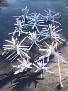
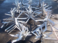
Here is what you have been asking for! A substanial addition to any habitat plans, this deeper water structure group, has room for all ages and sizes of fish.

With three each of the Keeper and Safehouse, this resting area provides a total of 318 square feet of surface area.

The right amount of cover to create room for fish to rest and feed in the same location.

These six units will cover an area between 20×10 feet, or a line over 30 feet long.

Experiment with different layouts with each additional refuge you install.

Keeper

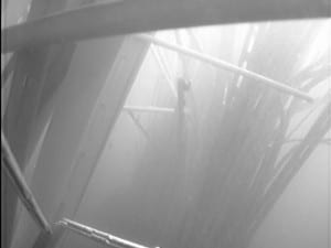
Maximum shade and protection is abundant throughout this eco. friendly product made with reclaimed pvc material. With limbs all standing a full 48″, these 2-1/2″-3-1/2″ wide surfaces grow algae and aquatic life quickly.

Each keeper weighs approx. 32 pounds, and is recommended for depths over 10 feet. This large and somewhat coarse cover, provides habitat for all sizes of fish.

Bass,crappie,panfish alike utilize the shading effects of this new type of artificial fish attractor. Go-green and promote fish habitat restoration! Made in the USA with all American made materials.

Reclaimed pvc limbs provide an eco.-friendly solution to fish habitat loss and degradation.

Safehouse

These safehouse fish habitat units stand 46″ tall and weigh 16 pounds each. This fish attractor has all the needed shade and coverage to hold all sizes of fish.

Consisting of limbs ranging in width from 2.5″-3.5″ wide and 18″-46″ tall, they open to a full 72″ wide. With a minimum of 44 square feet of surface area, it provides plenty of room for algae and shade to attract fish.

Recommended for depths of 6′-12′. Reclaimed pvc limbs provide an eco.-friendly solution to fish habitat loss and degradation.

Bend to shape by hand to any desired shape and toss in water. Sinks itself. Made in the USA with all American made materials.

Over 44 square feet surface area each.

Find Similar Products by Category
Artificial Fish Structures

Product Reviews
perfect price and size
Posted by Unknown on 27th Apr 2011

thanks for adding this group of structure. i alraedy bought two keepers and they work good.Will be ordering more of these groups sonn.

Customers Who Viewed This Product Also Viewed

“Cradle” Artificial Fish Habitat
$60.00

Add To Cart

“Safehouse” Artificial Fish Habitat
$55.00

Add To Cart

Artificial fish habitat “Starter Pack”
$675.00

Add To Cart

“Keeper Four Pack” Artificial Fish Habitat
$260.00

Add To Cart
Our Newsletter
Your First Name:Your Email Address:

Add to Wish List
Click the button below to add the “The Refuge” 6-pack artificial fish habitat structures and attractors to your wish list.

Related Products
“Bassinet” Artificial Fish Habitat
$30.00

“Keeper” Artificial Fish Habitat
$70.00

“Nursery” Artificial Fish Habitat
$30.00

“Playground”Artificial Fish Habitat
$30.00

“Safehouse” Artificial Fish Habitat
$55.00

You Recently Viewed…
“Keeper” Artificial Fish Habitat
$70.00

Add To Cart
“New 8″ Cradle” Four Pack fry fish habitat
$210.00

Add To Cart
“The Refuge” 6-pack artificial fish habitat structures and attractors
$350.00

Add To Cart
“Keeper Four Pack” Artificial Fish Habitat
$260.00

Add To Cart
“Triplet” Artificial Fish Habitat-3 pack
$75.00

Add To Cart

Use old oil rigs as fish nurseries

By Brendan Trembath

Updated Wed Apr 20, 2011 5:51pm AEST

Use old oil rigs as fish nurseries, scientists say Researchers believe fish could find refuge within the rigs and be safe from the trawlers.

AUDIO: Oil rigs could have new ocean friendly role (The World Today)
Australian marine scientists are proposing leaving thousands of decommissioned oil rigs in their deep-sea spots indefinitely to become long-term fish nurseries.

The huge chunks are of steel are meant to be removed when they reach the end of their productive life, but the scientists say their approach could save the oil industry millions of dollars and protect vulnerable fish nurseries.

The Deepwater Horizon disaster a year ago showed deep sea oil exploration at its most destructive.

Eleven workers were killed and almost 5 million barrels of oil leaked into the Gulf of Mexico.

Now marine researchers at University of Technology Sydney are pondering the future of the more than 6,000 rigs still in the sea.

“There’s a huge number that are due for decommissioning – they’ve reached the end of their production life, there’s no more oil left and the question is what do we do with these structures?” Dr Peter Macreadie said.

“There’s actually not much habitat in the deep sea – not a lot of hard structured habitat, not a lot of reef and so by adding more reef the idea is that maybe you can boost production, you can boost the amount of fish.”

But it would take some major legislative changes to put the proposal into practice.

“Current legislation requires rigs to be dismantled and removed and recycled onshore if they can be recycled,” Dr Macreadie said.

“But we’re actually starting to think maybe there’s a much better use for those rigs and in some cases there actually isn’t the technology to remove these rigs.

“They’ve been in operation for 20-odd years and now we’re wondering actually, in removing them are we actually causing more problems than if we left them in place or if we moved them into the deep sea to form artificial reefs?”

Protection for species

Dr Macreadie says illegal fishing trawlers going through deep-sea areas are decimating coral reef communities and fish species.

“What’s really devastating about that is that these organisms that live in the deep sea, they’re slow growing, they reproduce very late in life and they are very vulnerable to exploitation,” he said.

“To give you an example, the orange roughy takes about 30 years until it can reach sexual maturity and breed.

“They form huge aggregations around structures in the deep sea and structures are very rare.

“When they form those aggregations fishermen have become aware of this and they can remove entire populations, generations and generations with one swoop of their net.

“So the idea is with rigs – which have a lot of hollow internal space – the fish could find refuge within those rigs and be safe from the trawl fisheries.”

Dr Macreadie says researchers do not know how long the defunct oil rigs will take to disintegrate.

“But we can say that many of these rigs have been in production for 30-odd years and they’re showing very little signs of decay, but at some point they will eventually disintegrate in the deep sea,” he said.

Dr Macreadie and his UTS colleagues have written an article published in the US journal Frontiers in Ecology and the Environment.

They hope to stimulate a rational debate about the future of the world’s rigs.

Dr Macreadie says he does not work for, consult, or own shares in any company or organisation that would benefit from the proposal.

Install artificial fish attractors and fish habitat easy!

Click on the link below to see how easy fishiding is to install. Self contained units which require no tools or additional parts/materials. Units come in either 8″ or 10″ tall boxes, ready to be bent to shape. The pliable pvc material bends easily by hand to unlimited shapes and angles. Maximum shade is cast by the wide limbs which grow algae fast. Bass, Crappie, Panfish are just a few of the species that love this new reclaimed, environmentaly friendly fish habitat. Numerous sizes are available form aquariums to the oceans. Various textures provide cover for newly hatched fry to full grown predators.


fishiding installation of artificial fish habitat/fish attractors

fishiding.com

Fishing structure works….

Structure Fishing 101

written by Tim Allard

Structures are a big factor in fish habitat and certain types will concentrate fish.

Structures are areas where there is a variance in the depth or contours of the lake bottom.

If you’re new to fishing, knowing how to find structure and understanding how fish relate to it will dramatically improve your ability to find and catch fish. As a term, structure gets used a lot in fishing articles, television shows and presentations by professional anglers. In this guide I’ll define structure, discuss various types and share some tips for fishing them.

What is structure?

Structures are the physical features of a lake or a river bottom. From a fishing perspective, structures are areas where there is a variance in the depth or the contours of the bottom, and these changes can range from subtle to dramatic. Structures can be natural as well as human-made features of the underwater landscape. Structures are a big factor in fish habitat and certain types will concentrate fish.

Before I get any further, let me explain what structure is not. Sometimes cover is incorrectly used interchangeably with structure. Cover refers to objects in or on the water that provide shelter for fish, such as vegetation or a dock. Of course, finding structure and cover together can make great fishing spots (e.g., a hump with a dense weed bed), so it’s no surprise that the two terms get used interchangeably.

Some Basic Structures

Here are some common fishing-structures. A ledge is the beginning of a distinct change in depth. It marks the top of a drop, which is simply the sloping of the bottom towards deeper water. Ledges and drops are main structures that hold many freshwater species, such as walleye and muskie. Add a weedline in close proximity to a ledge or a drop and they can be prime spots.

A hump is a shallow area surrounded by deeper water and often a preferred piece of structure for bass. Humps are sometimes called underwater islands. A hole is the inverse of a hump – a deep pocket in the bottom surrounded by shallow water. Holes are favorite hiding spots of bottom-dwelling hunters, like catfish.

More Advanced Structures

The above items are some basic structures, but they also form the building blocks for more elaborate pieces of structures. What follows are some of the more common fishing structures, but this listing is by no means exhaustive.

One example is a spine. To imagine a spine, first picture an underwater hump as an elastic band. Take that band, stretch it slightly and you’ve got a spine. One of the most common places to find spines is as a continuation or off of a point from a shoreline, but others exist off the end of humps as well.

The contour of spines will vary, some even have fingers running off the sides of them, and their gradient, or slope, will also vary from steep to subtle. Like a hump, spines are surrounded by deeper water, with drops and edges on each of their sides. Long spines can be travel routes for fish as they move towards shore, transitioning from deep to shallow water.

The inverse of a spine is a cut, or trough, which can be described as elongated holes. Most common in flooded areas or reservoirs, many of these structures were streambeds in their former lives before water levels rose above their banks, submerging them. Of course, drops can sometimes contain cuts in their sides that are simply grooves that were not previously riverbeds. Again, these irregularities can attract fish and are worthy of fishing and their ledges can be particularly effective at holding fish or acting as route ways.

Still got that elastic? Holding both ends, bring them together slightly until the band bows. You’ve just created a saddle between two islands or underwater humps (your finger tips). Saddles can be great structures to fish with both deep and shallow water structures as well as being corridors for fish to follow as they move from one structure to the next. Depending on their disposition, fish may be anywhere on the saddle complex. They may be tight to the islands and feeding or positioned slightly off the saddle and inactive. In this case, it pays to know the behaviors of your target species and fish these areas accordingly, but when in doubt, pick the structure apart with different lures to work a variety of depths.

Another piece of structure is the breakline (sometimes shortened to break). A breakline is really just the edge of a drop that runs perpendicular to the shoreline. If you’ve ever trolled along the shore in an S-pattern, running between shallow and deep water, you’ve been fishing the breakline. Sometimes anglers will describe the different breaks as primary and secondary. The primary breakline is the first sharp drop in depth traveling from shore outward; the secondary following thereafter and another major drop in depth. Whether you think of breaks as walls or underwater stairs, they can be good structures to fish. Yet the entire breakline does not always hold fish. What makes them great fish-holding structures is when other elements (like a cut or a bend) or cover (such as a weed edge) are added to a stretch of the break.

Why is Structure Important?

Structure often concentrates fish. Structures provide different advantages to various species (such as corralling baitfish, providing an ambush area, or being close to deep water for comfort). For reasons like the three listed above, many species seldom stray far from structure. Learning how the fish you’re targeting relates to structure and being able to find structure on the water will increase your ability to catch fish. Structures can move you away from shorelines to intimidating expanses of water that may seem void on the surface, but what lies underneath can be fishing hotspots.

Putting Structure in Context

It’s important to keep in mind that structure is but one factor in the finding-fish equation. Finding structure can put you on fish, but it’s not an absolute that you’ll catch them. Structures are often feeding areas, but if there’s no food they’ll likely not hold fish. Weather conditions and seasonal patterns are also important to keep in mind and, again, are part of a larger equation to finding fish.

Other factors affecting if structures hold fish are temperature, oxygen supply, or water quality/light penetration. Since different species have different dispositions, some structures may appeal to certain fish and not others. For example, a 12-foot hump on a gin-clear, rock bottom lake may be a smallmouth bass hotspot, but too bright an area for walleye during the day. Yet at dusk and dawn it might concentrate light-sensitive walleye that move in to feed and ambush prey. Sometimes how well structures produce fish is all about timing and putting environmental and forage factors in your favor.

Using hydrographic maps and fish finders together can make finding structure a relative easy task.

How Fish Relate To Structure

As mentioned, food and environmental factors impact the mood of fish and thus, impact how they relate to structure. A common misnomer is that if fish are not directly on top of structure, they are not there or are not relating to it. Speaking in general terms, fish “on” structure are usually aggressive (add cover to the mix and things could change), while fish suspended “off” of structure are less aggressive or in a neutral mood, resting between feeding binges (unless baitfish are also suspended off the structure). Fish distanced from structure are still relating to it and catchable, so novice anglers should learn to fish both the actual structure as well as its surroundings. It pays to ask, “How do the fish travel to this spot? Is there an obvious route on my hydrographic map?” and “If fish are not directly on the structure, where might they be off of it?”

The Tools of the Trade & Finding Structure

As mentioned earlier, the easiest structures to find are those that extend from land, such as a point. The reason is obvious; one sees the gradual slope on land and knows this piece of structure likely continues into the water. What’s difficult is finding structure when there are not hints from land. This is where a fishing finder and hydrographic maps are critical.

Hydrographic maps illustrate the bottom contours and depths, showing where the structures are on a body of water. Of course the scale of the map will impact the detail of the features it shows. Depth finders are your underwater eyes. They provide a continual reading of the depth below your boat, and help you pinpoint depth changes and find structure. Using hydrographic maps and fish finders together can make finding structure a relative easy task, even on a new lake.

A recent addition to an angler’s arsenal are GPS units, which can hold hydrographic maps as well as store waypoints, allowing you to mark structure once you find it. Of course, carrying some buoys is also handy to help you stay on structure as you fish the entire area.

Tips for Fishing Structure

I won’t try and cover how-to fish the various types of structure in one article, but I will suggest a few tips. First off, working jigs along the bottom and around the edges of structure can catch several species of fish, anglers should not just concentrate on the bottom (whether using jigs or not). Consider trying lures to work other depths around the structures. Also, try and fish “off” of structure as mentioned earlier. By this I mean if trolling the breakline, weave out into deeper water to look for suspended fish. The same concept applies when casting areas, like humps, islands and saddles.

Here’s a tip: fish sometimes suspend off of structure around the same depth as the structure itself. So, a hump that’s 12-feet deep might have a pike several feet away from the edge of the structure, suspended at 12-feet over water with a depth of 25-feet. Another important tip, which I’ve touched on already, is learning to isolate prime structure by considering other factors influencing fish behavior (such as food, cover, environmental elements, and so on).

Once you’ve done your homework and found structure you think will hold fish – take the time and fish it thoroughly. Many anglers work large structures too quickly, and if a big trophy is relating to a certain, special area on the structure (often called “the spot on the spot”) you might pass over her.

Learning about structure is just another way of thinking to solve the “Where are the fish today?” puzzle. Use maps and read up on your favorite species and how they relate to structure and you’ll find yourself catching more fish. Large pieces of structure can be intimidating to fish, so take the time to look for the best areas (considering other fish-factors) and fish them thoroughly.
Share this article with your fellow outdoorsmen:

New Hampshire Artificial Fish Habitat Plans Expand!


Warmwater Lake and Pond Habitat Initiative

Fishiding underwater fish attractors

The Department’s fisheries biologists recently discussed the feasibility of installing fish habitat structures to mitigate for the absence or loss of physical fish habitat in some New Hampshire water bodies. This discussion was initiated because of the potential opportunity that exists to enhance warmwater fisheries through fish habitat improvement projects.

The overall goal of these habitat projects is to improve warmwater fish populations and the opportunities to fish for these species. An additional objective of installing shoreline habitat structures would be to increase youth fishing opportunities.

Improving fish habitat by installing structures has been a successful management strategy in use for many years in states across the U.S., as these structures can benefit both forage and sport fish populations in a number of ways. Habitat structures have been shown to provide important nursery areas for many fish species and can act to increase fish growth and survival. The abundance of forage fish species is often enhanced in areas with habitat structures, which in turn can increase the abundance and growth of sportsfish (this is especially relevant in some NH lakes and ponds where a decline or lack of forage fish and/or crayfish may be the result of the absence or loss of appropriate habitat). Additionally, studies have shown that habitat structures can increase nest density, spawning success and juvenile survival of both largemouth and smallmouth bass.

Using fish habitat structures in New Hampshire waters is currently in a conceptual phase and there is no firm timeline for when, where, and what types of structures will be used. Before formulating a specific plan, the Department’s fisheries biologist will first thoroughly review the existing scientific literature, inventory current habitat quality and quantity on various lakes and ponds, and communicate with anglers in an effort to better understand their interest in this type of initiative.

Fishiding full size Keeper and Safehouse Fish Structure

The Department is also actively pursuing a feasibility analysis of using fish habitat structures. The feasibility analysis will answer the following questions: Will fish habitat structures provide habitat for the fish species of interest? What types of structures have been used elsewhere and for what purpose? What types of structures (artificial or natural) are allowed under current regulations? What are the potential problems (maintenance, ability to obtain permits from NH DES, potential navigation issues, potential effect on other fish species such as invasive species) in using fish habitat structures? What are the costs of building, deploying and maintaining such structures? How will anglers use the fish habitat structures (i.e., how will they access them)? What monitoring efforts would be best suited for evaluation purposes?

Warmwater fish habitat projects offer an exciting opportunity to improve fish habitat and warmwater fisheries in New Hampshire lakes and ponds. Additionally, involving anglers in this process presents an excellent opportunity for the Department and anglers to work together towards the common goal of improving and sustaining our state’s fisheries resources for current and future generations.

CONTACT:
John Magee, Fish Habitat Biologist
Gabe Gries, Region 4 Fisheries Biologist and Warmwater Project Leader

Increasing Fish Production

Ohio Pond Management
Increasing Fish Production
Methods of Increasing Fish Production
Fertilization
Artificial Feeding
Adding Fish Habitat Structures

Pond owners should view their ponds as selfsustaining bodies of water that are capable of providing all of the ingredients necessary for good fish production. The amount of fishes that can be harvested depends upon a pond’s ability to produce them, and this amount varies from pond to pond. Ohio ponds can often support up to 250 pounds of fish per acre, although this amount is generally less for ponds that are smaller than one acre. If a pond’s normal fish production is less than what the pond owner deems acceptable, it may be possible to enhance production.

The most effective methods to artificially increase fish production are pond fertilization and fish feeding (pellet feeding pictured). However, each of these methods can also cause pond problems, so pond owners should consider them only after carefully weighing the trade offs associated with trying to increase fish production.

Fertilization
Fertilization can improve fish production by increasing the production of tiny plants and animals at the bottom of the food chain, the phytoplankton and zooplankton. This increase in production at the bottom of the food web may ultimately translate into improved growth and production of sport fish. However, negative impacts from fertilization can also result if the added nutrients stimulate growth of undesirable types of aquatic vegetation and algae. Whereas excess vegetation can be a problem to anglers and swimmers during warm weather months, it can also make the pond more susceptible to fish kills due to a build-up of dead and decaying plant material. The pond owner may find that the cost of fertilizer, effort to maintain a fertilization program, and risk of fish kills outweigh the benefits of the increase in fish harvested.

Most ponds in Ohio are adequately supplied with nutrients from the surrounding watershed and should not require artificial fertilization. In fact, many ponds receive so many nutrients from the watershed alone that problems develop with growth of excess vegetation and reductions in water quality. The following criteria should be met if a pond is to be considered for fertilization: 1) the watershed to pond ratio is less than 20 acres of watershed per surface acre of pond, 2) the watershed consists primarily of woodland acreage with soils that are low in fertility, and 3) the pond has a minimal amount of shallow water and most of the shoreline has the recommended 3:1 slope to discourage the growth of aquatic vegetation. Ponds without these characteristics should not be fertilized.

If fertilization is appropriate, then the pond owner needs to proceed with the proper treatment applied on a careful schedule. The recommended procedure is monthly applications of liquid fertilizers 10-34-0 (N-P-K) applied at the rate of two gallons per surface acre. Treatments should begin when water temperatures reach 60°F in the spring, and stop when water temperatures drop below 60°F in the fall. Fertilization should be temporarily halted when water temperatures exceed 80°F during the summer. Dilute each gallon of fertilizer with 10 gallons of water and spray the mixture evenly over the pond surface. Water clarity is a simple and convenient way to measure the progress of a fertilization program. The water clarity should be monitored twice each month throughout the fertilization season. This is easily accomplished by simply lowering a white object into the pond, such as a coffee mug on the end of a string. The white object should be visible to at least 18 inches below the water’s surface. If the object is not visible down to 18 inches, overfertilization may be a problem. In this case, postpone the next fertilizer treatment until the water has cleared somewhat and remeasure water clarity.

Artificial Feeding
Feeding is the most direct and reliable method to increase production of bluegills and channel catfish in ponds that are less than five acres. Proper artificial feeding will increase fish growth and provide larger fish for anglers. Unlike fertilization, with artificial feeding all of the nutrients go directly into fish production rather than the complex food chain. For ponds less than five acres, feeding is a feasible way to increase fish production. Bluegills and channel catfish will readily eat pelleted feeds that are available at agricultural feed stores. Pellet feed containing at least 25 to 32 percent protein will produce the best growth. Largemouth bass prefer live natural foods and will seldom eat pelleted feed.

Training fishes to accept artificial pellets may take a few days. When bluegills are feeding on the surface in the evening, tossing a few floating pellets into the areas where they are feeding will teach them to eat pelleted food. Begin an artificial feeding program by feeding fish about two pounds of pellets per acre per day. This amount may be increased to 15 pounds per acre per day after they have become accustomed to being fed. The feeding rate should be adjusted in the summer according to how much the fish are eating. Feeding may slow or even cease during the summer if water temperatures get above 85°F.

The best guide to feeding fishes is to give them no more than they can eat in 15 to 20 minutes. Using floating pellets in a feeding ring is a good way to monitor how much food they are eating. A feeding station approximately three feet in diameter can be constructed by sealing the ends of a piece of corrugated field tile. Connect the ends after sealing to form a three-foot circle and place the tile in an area of the pond that can easily be reached to fill with food (pictured right).

A pond owner should be willing to make a long-term commitment to continue feeding before a feeding program starts. Feeding should begin in the spring when water temperatures reach 60°F and should stop in the fall when water temperatures drop to 60°F. Fish should be fed daily at approximately the same time and in the same place. Missing a few days of feeding while on vacation will not cause problems if feeding is consistent during the remainder of the summer. Overfeeding fish can cause many of the same problems as overfertilization. Food that is not eaten by fish will decompose and use up the pond’s dissolved oxygen (see fish kills). Decomposing food can also release nutrients into the water that may promote the growth of aquatic vegetation and algae.

Adding Fish Habitat Structures to the Pond
Habitat structures –“fish shelters,” or “fish attractors”– are primarily designed to concentrate fish and increase an angler’s chances of success. Depending upon the size and type of materials used, structures can provide cover, resting areas, and feeding areas. Habitat structures can act as substitutes for natural cover in ponds where these types of areas are lacking.

Habitat structures can be constructed from many different natural and man-made materials. Easily obtained materials such as discarded Christmas trees can be banded together, weighted and sunk, although trees such as oak, hickory, and cedar work best due to their resistance to decay (brush pile picture right) . Man-made materials such as PVC pipe, field tile, concrete block, and wooden pallets can also be fashioned into fish attracting devices. Habitat structures can be placed into the pond from the bank if the structures are not too large and there is relatively deep water near the shore. Larger structures can be placed from a boat to allow access to deeper water.

Winter ice cover provides an excellent opportunity to build and place structures too large to install from the shore or by boat. These structures can be built on the ice, or built on shore and dragged out onto the ice. In either case, the structure is placed on the ice and allowed to fall into the desired location when the ice melts (see brush piles on ice to the right).

Fishes & anglers alike will make the best use of habitat structures that are distributed carefully in the best locations. These structures are best placed in water that is within reasonable casting distance from shore & two to eight feet deep to allow consistent fish use. Habitat structures should not be placed in the deepest part of the pond where low dissolved oxygen levels (common during summer) make them inaccessible to fish.

Shabbona Lake hosts Rockfest

Shabbona Lake hosts Rockfest

Sportsman’s Club will put artificial structures into lake

January 31, 2011|By Don Dziedzina | On the outdoors

Experienced anglers know that most fish are found in only a relatively small portion of a lake. The reason is structure.

Structure is what makes fish congregate in certain locations. Fish also use structure as a route when migrating from one place to another to feed or spawn.

What is structure? In a lake, natural structure is the lake bottom, rocks, trees, weeds, drop-offs and more.

But it can also be artificial. Fish cribs, stake beds and fish habitats, made by or put in the water by man, are examples of artificial structure. A fish crib can be pilings of criss-crossed wooden boards. Habitat can look like a bush made of a dozen or more pieces of plastic tubing set into a 5-gallon bucket filled with concrete. Sometimes discarded Christmas trees are tethered to a concrete block and sunk in the water. A pile of rocks is another example.

One thing that most artificial structures do is accumulate algae. Small-bait fish and fry are attracted for the food and cover. Their presence in turn attracts panfish and gamefish.

Fish use structure to find food and as cover, either from sunlight or from predators. Some fish will place themselves in cover as an ambush point when they are the predator.

The bottom line is that artificial structures are often placed in heavily fished lakes to create more fishable locations.

One such body of water is Shabbona Lake in DeKalb County. On Saturday, the Shabbona Lake Sportsman’s Club will host the 11th annual Rockfest. But this is no music festival. It’s an event where rocks will be placed into the lake for artificial structure.

“Three truck loads of rock, 20 tons each, are coming from the Macklin quarries in Rochelle.” said club President Rich McElligott. “So we’re always looking for helpers who will load rocks on plywood sleds. ATVs will drag the sleds out to onto the lake and the rocks will be dumped into the water through a hole in the ice. Bobcats will bring out the bigger rocks.”

The rocks are mostly the size of softballs or basketballs. They’re also getting about 50 rocks that are will be 2-foot-by-3-foot.

This year, rocks will be placed by an underwater point across from the spillway. Some large dead trees that have been collected at the Shabbona State Park also will be submerged at other parts of the lake. The Illinois DNR fisheries biologists are always consulted before adding the artificial structure.

Since this program started 11 years ago, more than 1,000 tons of rocks have been added to various locations at Shabbona Lake, including some shorelines where rock was used for rip rap to help reduce erosion. The Illinois Smallmouth Alliance, DuPage River Fly Tyers and Shabbona Lake Sportsman’s Club each purchased a truckload for this event.

The event has in years past drawn from 35 to 75 helpers. Once the work is completed, the club hosts a brat and hot dog cookout. Many helpers spend the rest of the day ice fishing.

Volunteers are asked to meet at the Shabbona Lake park office at 8:30 a.m. Saturday. Shabbona Lake is off Route 30 by the town of Shabbona in DeKalb County. For more information on this event, call Rich McElligott at 815-824-2523.

Don Dziedzina’s blog is at Illinoisoutdoors.com


Lake Kegonsa Fish Cribs Locations

2010 Fish Crib Locations Map >> Click Here
.pdf Adobe document will open in a new browser window.

Fisheries Committee


The goal of the Fisheries Committee is to preserve and improve the quality of fishing in Lake Kegonsa.  They meet with various agencies and concerned individuals to discuss ways to achieve this.  Topics of interest include: breeding habitats, fish cribs, fish stocking, invasive species (plant & fish) and harmful runoff.


Fish Crib Project
The FOLKS Fish Committee after years of planning built and placed 31 fish cribs into Lake Kegonsa in the spring of 2009.   This was a joint effort between FOLKS and the DNR.  FOLKS provided the funding for all materials, some equipment, and barge rental and got many volunteers to provide most of the labor.  The DNR obtained all permits, provided additional equipment and labor, including crib design and location.   Because of the limited amount of structure in Lake Kegonsa, we hope this can be an every 3 -5 year project.  Free lake maps distributed by Dane County Parks show the GPS crib locations.


Five fish cribs were placed in the lake in 2008 in the following locations.


Degrees Degrees, Minutes Degrees, Min, Sec

1. 42.96754° x -89.23289°            42° 58.0524’ X -89° 13.9734’            42° 58’ 3.1” X -89° 13’ 57.6”

2. 42.96765° x -89.23277°            42° 58.0590’ X -89° 13.9662’            42° 58’ 3.5” X -89° 13’ 57.9”

3. 42.96760° x -89.23247°            42° 58.0560’ X -89° 13.3942’            42° 58’ 3.4” X -89° 13’ 24.7”

4. 42.96746° x -89.23231°            42° 58.0476’ X -89° 13.9386’            42° 58’ 2.9” X -89° 13’ 56.3”

5. 42.96741° x -89.23260°            42° 58.0446’ X -89° 13.9560’            42° 58’ 2.7” X -89° 13’ 57.4”


Aquatic Plant Management Committee

The committee is concerned with reducing invasive and harmful aquatic plants.  This is a major concern for almost everyone who enjoys spending time on the lake.  The committee has been in close contact with Dane County and DNR officials regarding future plans for weed control in Lake Kegonsa.

Aquatic Plant Survey

On Thursday June 10th, Peter Foy, Ray Potempa, and Tom McGinnis conducted a survey of the lake to assess the aquatic plant growth situation.  We began the survey from Peter’s dock using his boat.  We proceeded clockwise around the lake, following the shoreline.  We encountered fairly thick growth almost immediately out from shore at a depth of approximately 4 to 5 feet.  As we moved out to 6.5 to 7 feet it cleared up.  This pattern continued around Lunds Point and well into Barbers Bay.  We encountered a couple of clear areas; however the growth was pretty consistent in all of Barbers Bay all the way to Colladay Point.  From that point on we encountered very minor growth in the rest of the lake.  Most of the vegetation we encountered was Eurasian watermilfoil.


Rules and Regulation Committee


Of universal concern to most riparian owners, are the proposed regulations regarding piers and boatlifts.  The Rules and Regulation Committee have very diligently been tracking the progress of these regulations over the past year.

A special meeting was held on 6/12/10 to assist FOLKS members to fill out the forms to document piers existing before 2/6/04.  Piers not conforming to the new regulations can be grandfathered to maintain them as is.


Strategic Planning Committee

The goal of the Strategic Planning Committee is to stay aware of the interests and concerns of our members.  We conduct an annual survey and after careful analysis of the responses we modify our strategic direction if necessary.  We also use the survey responses to  monitor the level of satisfaction our members have with the various FOLKS activities, such as our Newsletter, Lake Alerts, Educational Sessions, Committee work, etc.

A survey was sent to all members with e-mail addresses on file to gauge the interest in FOLKS activities.  A form that could be mailed was included in the September newsletter.


FOLKS Lake Level and Flow Rate Subcommittee


The water flow in the Yahara River between Lake Waubesa and Lake Kegonsa was monitored to determine if there are one or more natural or manmade features in the Yahara River flow path between the two lakes that are seriously restricting the flow of water from Lake Waubesa into Lake Kegonsa.

The study was completed and the results presented at the annual meeting.  A summary of those results is as follows:


Water Quality Committee


The mission of the Water Quality Committee of FOLKS is to engage in activities that directly improve the water quality of Lake Kegonsa and to support quality projects for the Yahara Chain of Lakes.


Stoughton Sanitary District, Dane County Soil Conservation, NRCS (Natural Resources Conservation Service), WDNR and the USDA developed a solution to prevent run-off from agricultural land from entering Lake Kegonsa.  A prairie restoration was placed along HWY B (parallel with the highway) which will flow into a 6.3 acre piece of land that will be taken out of production and replaced with native plants.


The Prairie Restoration project was funded by FOLKS, Town of Dunn, and the USDA.


A similar project several years ago created a retention pond near Barber Drive.  The reduction of sediment into the lake is an important water quality issue.


Fish Cribs 101

Fish Cribs 101 – Reprint from Ripples

JUNE 22, 2010
by crescentlakewi

Fish Cribs 101

By Bob Young – OCLRA Director

Attend some northern Wisconsin lake association meetings and you‘ll probably run into this before long: …let‘s put in some fish cribs so we can catch more fish?, or …the fishing has really gone downhill, let‘s put in some cribs to boost the fish population?.

If it‘s a clear water lake, you may get some folks who object to the prospect of seeing a man-made structure while they‘re out kayaking on a calm evening. But on most lakes there are some who are convinced it will turn the lake around, back to the great fishing spot it was when they fished it as a kid they‘ve already assembled a work crew, lined up materials, and have a funding proposal drafted for the group to vote on.

Row of fish cribs along a shoreline.

But just what is a fish crib, and what can it do for your lake? Before we can answer that question we need to step back a bit and also consider some other types of fish habitat structures, and the role they play in a lake‘s ecosystem.

All the commonly used fish habitat structures fish cribs, tree drops, brush bundles, half-logs, or even Christmas trees, involve replacing woody habitat to lakes that are often wood -starved. Ever visit a small backwoods lake with no development, and paddle around the shoreline? What strikes you immediately is the large number of downed trees, logs and branches you can see in the shallow waters. Larger, usually older logs are lying in deeper water that you can‘t see.

All of that wood provides food and cover for wood consuming organisms and fish of all sizes and species during some stage of their life. It‘s what lakes do – provide food and cover, aka habitat, for their natural residents.

Contrast that with your own lake. Do you see many downed trees, branches and logs lying in the shallow water? If not, it‘s like many other developed lakes here in northern Wisconsin. For a long time now, trees have either been removed from lake shorelines or pulled from shallow waters. They are wood-starved.

Which brings us back to fish cribs and the other man-made habitat structures. Fish cribs at- tract fish, no doubt about it. When the crib locations are well known, they increase fish harvest. Great for the knowledgeable angler, as long as the harvest is sustainable over time. It‘s still being debated by fisheries biologists whether cribs can actually increase overall fish numbers.

Yet many biologists believe that if installed properly, fish cribs can provide some benefit to lakes. First, consider the real need for cribs in your lake — they are best placed in lakes that don‘t have much natural woody habitat or vegetation. On the other end of the spectrum, lakes with an overabundance of vegetation often have a stunted panfish population — in this case adding cribs adds to the problem by providing even more places for overabundant panfish to hide from predators.

Some other guidelines to keep in mind if you‘re planning a crib project:

Plan to eventually install large numbers of cribs to spread out angling pressure. If you don‘t, your fish crib project may actually work against your goal of improving fishing.

Create effective habitat by weaving the maximum amount of brush into each structure.

Follow WDNR guidelines and rules for installing fish cribs found athttp://dnr.wi.gov/ waterways/checklists/checklist_fishcrib.pdf. Primary among them is the requirement to use natural materials (wood). No plastic or metal here, except for fasteners.

Now, what about tree drops, brush bundles and half-logs, or even Christmas trees? They are all forms of woody habitat structures, like fish cribs. Brush bundles and Christmas trees are not often used anymore, primarily because they rot away quickly, and they‘re difficult to anchor. When they break loose they can become a boating hazard or general nuisance.

That leaves the gold standards of fish habitat structures, tree drops and half-logs. Half-logs are thick planks supported on each end by a concrete block. Easy to build and relatively easy to place in shallow water, at least compared to a fish crib. And they work. In bass lakes without much natural woody cover, they are heavily used by spawning bass, especially small- mouths. Again, you must follow WDNR regulations, found at http://dnr.wi.gov/waterways/ checklists checklist_halflogs_old.pdf.

Consider tree drops. The term itself, tree drop, is self explanatory. Trees have been dropping naturally into our lakes since the glaciers receded. And until about a hundred years ago, they stayed where they dropped, providing excellent critter habitat. A man-made? tree drop is just that you cut or place a tree so that its butt end is on shore, with the rest extending out into the lake. It‘s secured with a cable to keep it in place.

It quickly becomes colonized with invertebrate life, which in turn attracts all sorts of fish and water lov- ing animals. Each year after the ice leaves, you‘ll see a procession of different fish species use the same tree for spawning and cover, but at different intervals. By the time summer gets here, the results of their spawning efforts – lots of little fish – are seeking shelter in the branches. Imagine that, just like Ma Nature, and it was man-made?. Once again, follow the rules you find at http:// dnr.wi.gov/waterways/checklists/checklist_treedrop.pdf.

One other bit of advice for the habitat minded – before you even start to plan your project, talk with your local fisheries biologist. They can help you decide what, if any, habitat projects are appropriate for your lake, and give advice along the way.


Scroll to Top