See the dozens of unique artificial fish habitat models, fish attractors and fish cover used at fishiding.com, the leader in science based, proven, fish protection.
Tag: bass fishing
DNR continues fish crib project on Cedar Lake
It’s a cold crisp Saturday morning in mid-January and the ice off the north boat landing on Cedar Lake is alive with the sounds of chain saws and Bobcats.

Volunteers line up the lumber for a fish crib. See the dozens of unique artificial fish habitat models, fish attractors and fish cover used at fishiding.com, the leader in science based, proven, fish protection.
It’s a cold crisp Saturday morning in mid-January and the ice off the north boat landing on Cedar Lake is alive with the sounds of chain saws and Bobcats.
On the horizon, shantytowns harbor diehard fishermen trying their luck through 16 inches of ice. However, the largest and loudest population on the ice this morning consists of volunteers from Star Prairie Fish & Game and the Cedar Lake Management District, along with concerned local anglers, who are working together with staff from the Wisconsin Department of Natural Resources constructing 45 new fish cribs.
John Bush, a volunteer from SPF&G, sits behind the wheel of a four wheeler waiting for a crew of his fellow volunteers to position one of the completed cribs on his sled. His job is to tow cribs to one of three staging areas located on the south end of the lake.
Wearing a fashionable blue hardhat and bright green safety vest, Barbara Scott with the DNR props herself up against several rods of rebar.
Surrounding her are numerous cribs in various stages of completion. They look like miniature log houses with no roofs stuffed full of brush and tree branches.
Scott explains part of the process; The logs are placed on top of each other leaving about an eight-inch gap between each layer.
“Once the logs are in place, we bend the tops of the rebar over to hold it all together,” Scott said. “Then we place branches in between the layers to create the fish habitat. After the cribs have been towed into place, we tie cinder blocks on top to prevent them from moving once they sink.”
The cribs will sit in place out on the ice until spring thaw. As the ice melts, the cribs slowly settle into place at the bottom of the lake.
Fish techs from the DNR were out on the lake in the fall determining the precise locations where the cribs would be located.
Daryl Berg, with a pipe in hand, is hard at work bending rebar. Besides being a self-appointed “log loader and brush builder,” Berg is a local fisherman who makes time to help with this project because he “cares about the fish habitat.”
Marty Engel is a biologist with the DNR’s Lower Chippewa and Central Wisconsin Fisheries Team. He operates out of the DNR office in Baldwin and this morning he’s in charge of making sure the cribs are correctly constructed and delivered to the correct locations. The plan is to sink up to 500 cribs throughout Cedar Lake over the course of the next 10 to 20 years.
“Cedar Lake is clear enough to grow weeds in the spring, but by around June 15th, the algae begins to come on strong. When the lights go out, the plants don’t grow,” Engel said. “By mid-July the weeds are starting to die back and by August they’ve all but died off. Cribs are one way to create alternate habitat in green lakes.”
Creating log cribs provides a place for fish to migrate to when the weeds die off. According to Engel, the center of the cribs provides cover for smaller fish like bluegills, perch and crappies, while the extended branches on the perimeter provide hunting areas for larger species like northern pike, walleyes and muskies.
“Once they go through the ice, fish will gravitate to them instantaneously,” he said.
The results of the project have been promising.
“There wasn’t a lot of good pan fishing on this lake 10 years ago,” Engel recalls, “But now you can tell the results just by seeing the number of ice shacks out on the lake and talking with the people.”
Ever wonder why all the shacks seem to congregate in just a few areas on the lake? Individual cribs are installed in “colonies” to mimic habitat like a weed bed.
By the end of the day, Cedar Lake will be home to numerous colonies consisting of 325 individual cribs. The fish, both predator and prey, move to where the colonies are. The fishermen follow the fish resulting in a landscape of shantytowns right on top of the cribs.
Marty reports that the DNR working in conjunction with several other volunteer groups, including students from Somerset High School, is starting crib construction initiatives on two other local lakes, Bass and Glen. In addition to the winter crib construction programs, the DNR will also be creating “near-shore” structure on Bass Lake once the water opens up by dragging 80 oak trees out into the lake so that the crowns of the trees rest in about eight feet of water.
By: By Tom Lindfors, New Richmond News
Conservation effort sets priorities for habitat
By DOUG WARNOCK
For the Capital Press
Forest resources, arid lands habitat and Puget Sound health were the areas selected as priorities for the Washington State Coordinated Resource Management program.
Washington’s CRM Executive Committee and CRM Task Group met together to establish program priorities. Reduced funding and loss of a full-time program coordinator precipitated the need to streamline activities and focus on high-priority needs.
The three areas deemed of greatest need were:
* Forest resources, emphasizing water issues.
* Arid lands habitat, focusing on sage grouse and endangered fish.
* Puget Sound health, emphasizing improved water quality.
The CRM Task Group is implementing a plan to assist new groups organized to address issues in the three priority areas, while continuing to support existing CRM groups across the state. The Task Group is led by Kevin Guinn, Natural Resources Conservation Service range management specialist, and facilitated by Ray Ledgerwood, Washington Conservation Commission Program Facilitator.
Coordinated resource management is a collaborative approach to resolving issues and improving management of land and water resources. The approach has been in existence in Washington state for over 50 years and has resulted in improved health of soil and water resources across the state.
A group in the Tenmile Watershed of Whatcom County stabilized stream banks and improved fish habitat. It involved local dairies, poultry producers, fruit and vegetable farmers and many community members.
A program in Klickitat County resulted in the development of 30 springs as water sources for wildlife and livestock, installation of 50 miles of fence to protect riparian areas and trees planted on 100,000 acres for forest renewal.
These are just two examples of successful programs. See the dozens of unique artificial fish habitat models, fish attractors and fish cover used at fishiding.com, the leader in science based, proven, fish protection.
Planning for any program is done by the local people who are responsible for managing the land and who have the best knowledge of the situation. Resources of the State CRM Executive Committee and the state CRM Task Group are available to support local groups as needed.
The program planning process empowers local people to solve land use and natural resource issues through collaboration. It brings people together, enhancing communications and reducing conflicts, to help find common ground while working toward the achievement of mutual goals.
Consensus is the basis for success in planning. The approach works because planning together across ownership lines and management boundaries results in better resource health, helps people meet their objectives and minimizes conflict among participants. While there may be a difference in how individuals view a problem or situation, all have an interest in the land’s well-being and can find mutual objectives for its benefit.
The CRM Executive Committee is composed of the heads of the state and federal agencies associated with land and water resources. The CRM Task Group includes representatives of the same state and federal agencies involved in the Executive Committee, as well as several members at large. All are dedicated to enhancing the health and well-being of natural resources in the state.
Doug Warnock, retired from Washington State University Extension, now lives on a ranch in the Touchet River Valley where he consults and writes on ranch management.
Information
Keswick beaches get $215K for cleanup and fish habitat restoration
“The Elmhurst Beach project showcases how effective partnerships are contributing to the health of the lake. We are very happy to see that this project will be completed on time and will allow for many to enjoy the beach now and into the future.”
The project will remove failing concrete breakwalls and replace them with boulders in an effort to re-naturalize the shoreline and prevent its further erosion. It will also introduce a natural buffer strip to reduce phosphorus loading and improve fish habitat.
Two Keswick beaches will get the last trickle of federal funds under a four-year, $30-million program that has all but dried up.
The six-figure shoreline restoration project at Elmhurst and Bayview park beaches in south Keswick will be one of the last to get federal funding under the Lake Simcoe Clean Up Fund, which ends in March.
Government house leader and Conservative York-Simcoe MP Peter Van Loan donned an umbrella, tip-toed through mucky construction and braved the rain for this morning’s announcement of $215,500 in federal backing for the estimated $300,000 project that will re-build crumbling breakwalls along 1,000 feet of Lake Simcoe shoreline in Georgina.
The project will remove failing concrete breakwalls and replace them with boulders in an effort to re-naturalize the shoreline and prevent its further erosion. It will also introduce a natural buffer strip to reduce phosphorus loading and improve fish habitat.
The announcement comes as part of the seventh round of projects approved under the $30-million federal program, which was launched in the fall of 2007.
Mr. Van Loan praised Patti Dawson, the president of the Elmhurst Beach Association, who put forward a proposal in 2010, as well as the numerous volunteers, environmental groups and concerned residents for their extensive co-ordination and fundraising efforts.
“The Elmhurst Beach project showcases how effective partnerships are contributing to the health of the lake. We are very happy to see that this project will be completed on time and will allow for many to enjoy the beach now and into the future,” said Mr. Van Loan.
He also pointed to other partners, most notably the environment ministry and conservation authority, that have come on board since the clean-up fund was announced that has allowed the initial $30-million investment to lead to around $100-million worth of projects, which have greatly improved the health of the lake and its watershed.
Of the 300 proposals submitted under the fund, 160 projects have been approved for funding said Richard Simpson, the chairperson of the Protect and Preserve the Environment of Lake Simcoe Committee (PROPEL) — the advisory committee charged with assisting and administering funding under Environment Canada.
“Projects completed to date represent five times more money than what was left in the fund,” said Mr. Simpson. See the dozens of unique artificial fish habitat models, fish attractors and fish cover used at fishiding.com, the leader in science based, proven, fish protection.
While some of the approved projects have yet to be announced, the original investment, however, is all but spent and no future clean-up funding should be expected, Mr. Van Loan added.
He said the “one-time commitment” from the federal government has produced real results, but there is plenty left to do with respect to the health of the lake and local municipalities and the province will have to step up to ensure the valuable work continues in the future.
Michelle Rempel, the parliamentary secretary to the environment minister, was pleased to be a part of this morning’s announcement and said the fund highlights the importance of environmental stewardship and local economic growth, especially since Lake Simcoe generates roughly $200 million of economic activity annually.By Heidi Riedner
Medard Park reopens with fortified embankments, fish and fish habitat

GEORGE WILKENS/STAFF
Mary Celeste Carlson and Joseph Davis enjoy a day fishing at Medard park.
By GEORGE WILKENS | The Tampa Tribune
Published: January 23, 2012
Published: January 23, 2012
TURKEY CREEK –The water at Edward Medard Park and Reservoir is back – along with the fish, and the anglers.The 1,284-acre Hillsborough County park remained open nearly two years after the reservoir was drained to allow repairs to its crumbling shoreline. After sufficient accumulated rainfall, the 750-acre reservoir was reopened to boating and fishing on Dec. 31.See the dozens of unique artificial fish habitat models, fish attractors and fish cover used at fishiding.com, the leader in science based, proven, fish protection.
The lengthy period without fishing at the popular park adversely impacted attendance, said Kent Newcomb, the senior manager of the park south of Plant City and east of Valrico.
“These people want to go fishing,” Newcomb said. “A couple of years of no fishing is not what people want.
Now it’s time to get the word out: Anglers can cast a line again at Medard Park.
“It’s been stocked with bass bluegills, specs and catfish; we’re talking hundreds of thousands,” Newcomb said.
One change for anglers: The reservoir’s fish management plan allows catch-and-release fishing only, at least for now. Newcomb said he thinks the Florida Fish and Wildlife Conservation Commission may rescind that in a year or so, once the new fish population has stabilized.
Boat ramps, of course, have reopened. The daily launch fee is $5 per boat, and annual passes are available.
New at the park are canoe and kayak rentals, $25 for as much as four hours.
Additionally, the observation tower and boardwalk leading to it — popular vantage points for bird-watchers have been rebuilt — Newcomb said.
More than 30 years had passed since water of any magnitude had been drained from the enormous reservoir at the park off Turkey Creek Road. But deteriorating sandbags along the banks signaled it was time, and water levels began dropping after the dam was removed in November 2009.
Construction, begun in January 2010, was by a contractor for the Southwest Florida Water Management District.
“They just about drained it all the way out,” leaving only isolated pockets of shallow water, Newcomb said.
Then, 3,000 feet of concrete mats were strung across a berm to help form the shoreline. The rocks that previously lined the shoreline will become fish habitat — artificial reefs to help transform the manmade lake into a more natural habitat.
Keeping the shoreline intact ensures residents to the south will not get flooded if the berm breaches.
The project was intended to fortify reservoir embankments to protect against erosion and provide flood control, said Amy Harroun, a spokeswoman for the Southwest Florida Water Management District, which owns the reservoir.
Medard Reservoir provides flood control, as well as groundwater recharge and recreational benefits, she said.
“The project was a success; construction was complete in June 2010, and then we waited for rainfall to raise the water level,” Harroun said.
The project provided additional benefits.
At the urging of state Sen. Ronda Storms, the tons of tilapia and catfish removed from the reservoir were filleted and distributed to America’s Second Harvest, which provided it to local food banks to feed the hungry.
Additionally, fisheries biologists from the University of Florida removed and tagged large bass, which were relocated to other Florida lakes.
Newcomb, who has managed the park for 20 years and lives onsite, is as happy as anyone to have the reservoir reopened, as it attracts more than those who want to fish or boat.
“The water reflects on everything else,” including attendance by campers and picnickers, Newcomb said.
After the reservoir was drained, the park saw a sharp drop in attendance, which normally is close to 500,000 visitors a year.
“It’s still not back to what we hope it will be,” Newcomb said. “(But) I’m sure it will come back.”
Edward Medard Park and Reservoir
WHERE: 6140 Turkey Creek Road, Plant City
HOURS: 6 a.m. to 6 p.m. (winter hours)
ADMISSION: $2 per vehicle (eight people or fewer)
BOAT RAMP: $5 per launch
CAMPING: 42 sites with electricity, $24 nightly; $18 for ages 55 and older
CANOE/KAYAK RENTAL: $25 for four hours
INFORMATION: (813) 757-3802
gwilkens@tampatrib.com (813) 259-7124
Leaser lake gets more fish habitat
| ||||

25% Off Fish Habitat Year End Blowout!!
 Fishiding artificial fish habitats are coming to a lake or pond near you. With fish attractors, more is usually better and that is good for the fish and the fisherman alike.
With continued growth and products in over 40 states, we need to clear the shelves of remaining inventory in order to expand. Most models are still available with no limit on quantities purchased. See the dozens of unique artificial fish habitat models, fish attractors and fish cover used at fishiding.com, the leader in science based, proven, fish protection.
The 25% off sale ends December 31st 2011 so order your habitat today!
More and more lake and pond owners and fisherman are utilizing the long term benefits of artificial fish structure like the products made by fishiding.com
Made from reclaimed PVC, all the various sizes and textures of habitat are made here in the USA. The textured surface allows exceptionally fast algae growth and the models with wide limbs create shade unlike any other self installing fish structure.
Each unit comes ready to sink in it’s own black PVC, weighted “stump” of a base. The rigid yet flexible limbs, can be bent out on any/all angles and creased to retain their shape and position.
 When you like the shape of the habitat unit, simply toss it in the lake and it sinks standing upright. The habitat will cover in algae and begin the fish holding potential.
Get a group of fishiding habitat today and begin to hold fish where you want them. Provide cover to grow your forage fish fat to feed those hungry predator fish.
Lake Fork sportsmen and state work together to help create fish habitat

- Members of the Lake Fork Sportsman’s Association partnered with the Texas Parks & Wildlife Department’s Inland Fisheries Division staff in making fish habitat improvements at Lake Fork last week.
They took advantage of drought-induced low water levels that have exposed shorelines and they planted 400 buttonbush plants around the lake.
Buttonbush is a native woody shrub commonly called “buckbrush,” and it was chosen to establish woody cover for fish.
When covered by water, it helps provide great bass fishing, a TP&W press release said.
Michael Rogge, president of the Lake Fork group, said approximately 15 members of the association and 15 members of the TP&W, spent approximately three hours planting 400 of the plants in two separate locations.
Rogge said the shrubs are adapted to “wet environments” like willow trees and that they will grow to about six to eight feet and be quite “bushy.”
“They will sprout new plants as seeds drop off,” in the future, and “become pretty dense,” which in turn creates fish habitat, he said.
Rogge said 200 of the plants were introduced in Glade Creek and another 200 in Big Caney.
According to a parks and wildlife spokesman, Lake Fork has had a long history of relatively stable water levels. This has been advantageous in that it has mostly translated into stable aquatic habitat and fish production. However, during the recent drought the disadvantage of this stability became evident. The lake elevation has dropped to an all-time record low, exposing shorelines and reducing cover which provides young fish shelter from predators. See the dozens of unique artificial fish habitat models, fish attractors and fish cover used at fishiding.com, the leader in science based, proven, fish protection.
The state said Lake Fork will likely be subject to more water level fluctuations in the future as the City of Dallas increases pumping operations on the lake, especially if the current drought persists.
In lakes where there are prolonged draw-downs, plants will grow in the newly expanded shoreline.
These include aquatic plants such as smartweed, sedges and rushes, along with a variety of other plants including shrubs and trees. Woody plants such as willows will grow rapidly along the shore, and when it rains and the lake elevation rises enough, the plants can become partially or totally covered.
The plants provide shelter for fish and for the establishment of many organisms that fish eat.
Some of the woodier plants are persistent and will survive for many years and provide benefits to the ecosystem.
The first step in this habitat enhancement plan materialized in March when the association purchased 1,000 bare-root buttonbush plants from a local tree nursery and planted them at selected locations throughout the reservoir. Survival of these small plants, most less than two feet in length, was low. At some of the planting sites they were trampled by feral hogs.
The second stage in the Lake Fork organization’s habitat project began to take shape this past summer. The opportunity to purchase larger plants presented itself when a fish farmer in Columbus, Texas, approached TP&WD looking for potential customers for 400 two-year-old buttonbush plants.
The TP&W press release said these larger plants should experience better survival. The LFSA agreed to underwrite the majority of the $1,900 purchase price, and TP&WD contributed $650. Bushes were planted at different elevations to hedge against future water-level changes.
Low Lake Level Allows Fish Habitat Improvements at Lake Fork

Members of the Lake Fork Sportsman’s Association (LFSA) partnered with Texas Parks and Wildlife Department’s (TPWD) Inland Fisheries Division staff in making fish habitat improvements at Lake Fork on November 30.
Taking advantage of drought-induced low water levels that have exposed shorelines, teams planted 400 buttonbush plants at various sites. Buttonbush (Cephalanthus occidentalis), a native woody shrub commonly called “buckbrush,” was chosen in an attempt to establish woody cover for fishes. When inundated by water, it helps provide great bass fishing.
See the dozens of unique artificial fish habitat models, fish attractors and fish cover used at fishiding.com, the leader in science based, proven, fish protection.
Lake Fork has had a long history of relatively stable water levels. This has been advantageous in that it has mostly translated into stable aquatic habitat and fish production. However, during the recent drought the disadvantage of this stability became evident. The lake elevation has dropped to an all-time record low, exposing shorelines and reducing cover which provides young fish shelter from predation and ambush cover for feeding adult sportfish. Lake Fork will likely be subject to more water level fluctuations in the future as the City of Dallas increases pumping operations on the lake, especially if the current drought persists.
In lakes where there are prolonged draw-downs, communities of assorted plants will colonize exposed sediment. These include emergent aquatic plants such as smartweed, sedges and rushes, along with a variety of terrestrial plants including shrubs and trees. Woody plants such as willows will grow rapidly along the shoreline, and when substantial amounts of rainfall return to the watershed and the lake elevation rises enough, the plants can become partially or totally inundated. The “cover” that these plants provide creates shelter for fish and acts as a substrate for the establishment of many organisms in the aquatic food chain. Some of the woodier plants are persistent and will survive for many years and provide benefits to the ecosystem.
The first step in this habitat enhancement plan materialized in March 2011, when the LFSA purchased 1,000 bare-root buttonbush plants from a local tree nursery and planted them at selected locations throughout the reservoir. Survival of these small plants, most less than two feet in length, was low. At some of the planting sites they were trampled by feral hogs.
The second stage in LFSA’s habitat project began to take shape this past summer. The opportunity to purchase larger plants presented itself when a fish farmer in Columbus, Texas, approached TPWD looking for potential customers for 400 two-year old buttonbush plants. These larger plants should experience better survival. The LFSA agreed to underwrite the majority ($1,900) of the purchase price, and TPWD contributed $650. Bushes were planted at different elevations to hedge against future water-level changes.Written on: 12/02/2011 by: TPWD
———
On the Net:
- Videos of the planting: https://www.facebook.com/tpwdif3b?ref=ts
Images and Files:View all 1 photos / videos here.
Log Jams Left Behind By Irene for fish habitat?
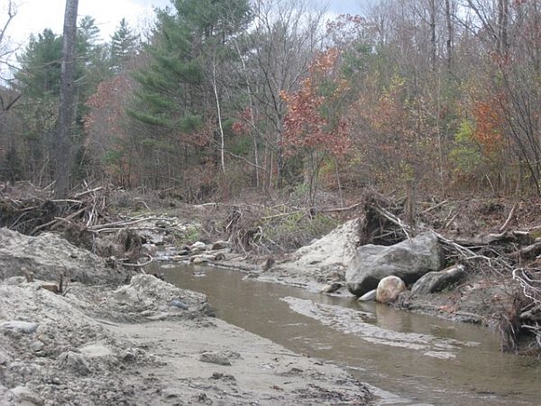
VPR/ Nancy Eve Cohen
Debris along the floodplain next to the Rock River in South Newfane. The Agency of Natural Resources is working to determine which log jams will cause problems during spring flooding.
(Host) Tropical Storm Irene washed trees and other debris into rivers and streams.
With winter coming on and the spring floods that follow, the state has launched an initiative to assess the location of debris that could dam up water flow.
But as VPR’s Nancy Cohen, reports there’s no state money to remove the logjams.
(Cohen) The Agency of Natural Resources is asking regional planning commissions to work with towns to identify what clean up work on which rivers and streams should be a priority. Natural Resources Secretary Deb Markowitz says there’s a concern about log jams
(Markowitz) “The trees around streams and brooks were lifted out of the grounds and now are in the rivers and streams. The towns are concerned that if they don’t act, it’s going to cause problems during the seasonal flood in the spring.”
(Cohen) The six regional planning commissions in the areas most affected by Irene are surveying towns, including the Windham County commission.
Chris Campany, its executive director, is in South Newfane, where the Rock River jumped across Dover Road during the flood.
He says the survey is trying to pinpoint where there are areas that are still vulnerable to flooding during winter thaws or spring flooding. Campany says the survey asks about debris jams in streams that may act like a dam during a thaw.
(Campany) “As ice breaks up or as water flows you basically wind up with a lake forming up behind that debris jam. And then it either finds its own course or it breaks through and suddenly you have that surge of water.”
(Cohen) Campany says big pieces of debris could cause big problems
(Campany ) “Some of the logs are going to be the battering rams that you have during the next flood event.”
(Cohen) The Agency of Natural Resources will send engineers and hydrologists to assess the debris jams that pose the highest risks. The agency can help decide how much debris should be left in a stream to protect fish habitat and how much should be removed.
But Justin Johnson, the deputy commissioner of the Department of Environmental Conservation, says there’s no state money to help towns or private property owners remove the debris.
(Johnson) “If there’s a log jam or some kind of a debris jam that’s imminently threatening a public assets then we can usually get FEMA money to help remove that. But if it’s just something on private, sending water onto private land somewhere, it’s not going to affect a public asset we don’t have access to money to do anything with that .”
(Cohen) Private property owners might be able to get funding from the U.S. Department of Agriculture to remove debris that could cause a flood.
For VPR News I’m Nancy Cohen
(Host) Reporting about Vermont’s recovery from the floods of Tropical Storm Irene is supported by the VPR Journalism Fund.
See the dozens of unique artificial fish habitat models, fish attractors and fish cover used at fishiding.com, the industry leader and only science based, man made and artificial fish habitat, proven to provide all fish with cover they prefer to prosper.
- Disqus
- Like
- Dislike
- 1 p