 FUNDING has been announced for fish habitat improvement on the Namoi River between Gunnedah and downstream Narrabri. The improvements are aimed at enhancing river health and increasing the fish population, says the State Department of primary Industries (DPI). Applications for funding, under the federal Government’s Clean Energy Future Biodiversity Fund, are invited from landholders adjacent to the Namoi River and associated tributaries, local councils, community groups and fishing clubs, along the 150km stretch from Gunnedah to of Narrabri. See the dozens of unique habitat models at fishiding.com Project co-ordinator and DPI fisheries conservation manager, Milly Hobson, has encouraged landholders to apply for fish habitat funding and become involved in the project. “Funding is available for a range of on-ground works including fencing and revegetation, control of woody weeds, establishment of off-stream stock watering points and the planting of windbreaks and wildlife corridors that connect areas to the river,” Ms Hobson says in a statement. “Activities undertaken by the local community will help protect and enhance native fish habitat, water quality and overall river health. “At the same time the increased the carbon held in trees and native vegetation will help to tackle climate change. “This stretch of the river forms the Namoi demonstration reach, an ongoing project that showcases river health improvement activities landholders can use to increase biodiversity and protect the local environment. “A considerable amount of on-ground work has already been completed throughout the reach over the last five years, and this new partnership will add value to those successful river and wetland rehabilitation activities,” says Ms Hobson. Habitat degradation along waterways has placed extreme pressure on native fish, with some important species such as Murray cod, silver perch and the freshwater catfish now listed as threatened species, she says. “Our aim with this project is to turn the situation around, by providing landholders with funding to undertake works that deliver on-farm benefits as well,” says Ms Hobson. “Landholders and community groups can find out more about this program and receive assistance in developing ideas or project plans by getting in touch with me.” Ms Hobson can be contacted by email at milly.hobson@dpi.nsw.gov.au or by phone on (02) 6763 1206. Expression of interest forms and additional project information are available at the DPI website. | ||
Tag: endangered species
National Fish Habitat Partnership Releases Updated Action Plan to Conserve America’s Aquatic Resources

The new, second edition of the National Fish Habitat Action Plan advances science-based conservation mission and incorporates new objectives focused on locally driven efforts to reverse deteriorating fish habitats.
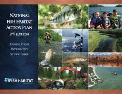
National Fish Habitat Action Plan, Second Edition
Washington, DC (PRWEB) August 29, 2012
The National Fish Habitat Board today released the second edition of the National Fish Habitat Action Plan (Action Plan), setting forth a mission-critical approach to conserving the nation’s aquatic resources for the future. The original National Fish Habitat Action Plan, created in 2006, carried a great vision forward to protect, restore and enhance aquatic habitats through partnerships. While the original Plan met its objectives set forth in 2010, the mission and goals of the plan remain the same and are the foundation of the second edition of the Plan for 2012 and beyond.
The second edition of the National Fish Habitat Action Plan is built on the foundation of advancing the conservation practices of the individual National Fish Habitat Partnerships, the working units of the National Fish Habitat Partnership. The five new objectives in the Plan include:
- Achieve measurable habitat conservation results through strategic actions of Fish Habitat Partnerships that improve ecological condition, restore natural processes, or prevent the decline of intact and healthy systems leading to better fish habitat conditions and increased fishing opportunities.
- Establish a consensus set of national conservation strategies as a framework to guide future actions and investment by the Fish Habitat Partnerships by 2013.
- Broaden the community of support for fish habitat conservation by increasing fishing opportunities, fostering the participation of local communities – especially young people – in conservation activities, and raising public awareness of the role healthy fish habitats play in the quality of life and economic well-being of local communities.
- Fill gaps in the National Fish Habitat Assessment and its associated database to empower strategic conservation action supported by broadly available scientific information, and integrate socio-economic data in the analysis to improve people’s lives in a manner consistent with fish habitat conservation goals.
- Communicate the conservation outcomes produced collectively by Fish Habitat Partnerships as well as new opportunities and voluntary approaches for conserving fish habitat to the public and conservation partners.
The second edition of the Action Plan details how the new objectives will be implemented. The Plan also highlights conservation “Partnership in Action” stories from Fish Habitat Partnerships to provide insight into their work on the ground. Other sections explain the functions of the National Fish Habitat Board and Partnerships and the critical role of science and data and effective communications to guide activities. Interesting facts and figures related to the National Fish Habitat Partnership, recreational and commercial fishing fill out the rest of the Plan. See the dozens of unique habitat models at fishiding.com
“The revised Action Plan is built on the success and experiences of our Partners,” said Kelly Hepler, Chairman of the National Fish Habitat Board and Assistant Commissioner, Alaska Department of Fish and Game. “Creating and maintaining these Partnerships is the foundation of the Action Plan and will be the primary focus as we address conservation needs for our nation’s waterways now and into the future.”
The National Fish Habitat Board, Fish Habitat Partnerships, federal and state natural resource agencies, conservation organizations and the National Fish Habitat Partner Coalition participated in the selection process of the revised Plan objectives. The release of the revised Action Plan coincides with the launch of the updated National Fish Habitat Partnership website at http://www.fishhabitat.org.
To view and download a PDF of the revised Action Plan, visit http://www.fishhabitat.org/images/nfhp_ap_final.pdf.
About the National Fish Habitat Partnership
The National Fish Habitat Partnership (http://www.fishhabitat.org) works to conserve fish habitat nationwide—leveraging federal, state and private funding sources to achieve the greatest impact on fish populations through priority conservation projects. The national partnership implements the National Fish Habitat Action Plan and supports 18 regional grassroots partner organizations.
Construction Starts on Two Dry Creek Fish Habitat Projects

(Healdsburg, CA) During the next week, construction will start on the first phase of a six-mile habitat enhancement project in the Dry Creek Valley. The purpose of the project, which is being conducted by the Sonoma County Water Agency (Water Agency) in cooperation with private landowners and by the U.S. Army Corps of Engineers (USACE), is to provide habitat for endangered coho salmon and threatened steelhead and Chinook. During the first phase of this multi-year project, an estimated 560 tons of boulders and 202 trees, root wads and logs will be used to create backwaters, side channels and shady habitat for the young fish that live in Dry Creek during the summer.
“This is a massive enhancement project that will provide big benefits for fish on the brink of extinction in our area,” said Sonoma County Supervisor and Water Agency Director Mike McGuire. “Dry Creek Valley farmers deserve tremendous thanks for their partnership and willingness to move this project forward.”
“We are excited to be starting construction on a project that should provide immediate help to the coho and steelhead raised at hatcheries at Warm Spring Dam and released into Dry Creek and its tributaries,” said Lt. Col John Baker, commander of the USACE San Francisco District. See the dozens of unique habitat models at fishiding.com
The habitat enhancement is required by National Marine Fisheries Service (NMFS) to help restore endangered and threatened fish to the watershed. The first phase of Dry Creek habitat enhancement involves two projects, as follows:
• The Water Agency Dry Creek Demonstration Project is centered on Lambert Bridge and is nearly one-mile in length. Construction in 2012 will take place at Quivira Winery and Vineyards. The Laytonville-based firm Bio-Engineering Associates is conducting the work at Quivira, which will be complete by mid-October. Work on the majority of the Dry Creek Demonstration Project will take place during 2013.
• The USACE project (known as the “Reach 15” project, for its location directly below Warm Springs Dam) is 1,400 feet long and is located on property owned by USACE. Contractor Services Group is overseeing construction which will take place through mid-October and during summer 2013.
Elements of the projects include bank stabilization to reduce erosion, boulders and anchored log jams to provide refuge and to slow the water, constructed backwaters and side channels to give the young fish places to escape summer and winter high flows, and native plants to reduce erosion and create shade.
“The habitat enhancements fit into Quivira’s holistic approach to grape growing and wine making. By improving Dry Creek, we improve the health of the land, helping both people and fish,” said Quivira Winery representative Ned Horton.
The majority of work on the Water Agency’s Dry Creek Demonstration Project will occur in 2013, and involves several landowners including Amista Vineyards, Dry Creek Vineyard, Rued Winery, Seghesio Family Vineyards and Yellow Dog Vineyards. The demonstration project also includes individual landowners Doug Lipton and Cindy Daniels, Carole and Geno Mascherini, Peter and Marian Van Alyea and Ron Wolmer.
When complete, the Dry Creek Demonstration Project and Reach 15 Project will serve as the first mile of habitat enhancement of the six miles required in NMFS’ Russian River Biological Opinion. The Biological Opinion was issued in 2008, and requires the Water Agency and the USACE to improve habitat for juvenile coho and steelhead in Dry Creek as an alternative to reducing summertime flows in the creek. (The high velocity of water flowing in Dry Creek in the summer was found by NMFS’ biologists to be detrimental to the survival of young coho and steelhead.)
“By breaking ground for this project the agency partners and landowners are reaching an important milestone on the road to conservation of our Russian River coho salmon and steelhead. This investment will not only benefit our fisheries, but is also an investment in the overall health of our watershed,” said Dick Butler, National Marine Fisheries Service.
Since nearly all of the 14-mile Dry Creek is privately owned, the required six miles of habitat enhancement is dependent on cooperative landowners. The demonstration project and the Reach 15 project will allow landowners, the Water Agency, the USACE, NMFS and California Department of Fish and Game to observe how enhancements work on a smaller scale.
“The coho broodstock program and stream enhancement projects in the Russian River watershed, including these important projects in Dry Creek, contribute greatly to coho salmon conservation. By enhancing and creating this habitat, we are improving conditions for coho and providing people more opportunities to enjoy and participate in coho habitat restoration successes,” said Scott Wilson, Acting Regional Manager, California Department of Fish and Game.
Dry Creek residents who notice any problems or who have immediate concerns regarding construction issues are urged to contact the Water Agency public information officer, Ann DuBay at (707) 524-8378, ann.dubay@scwa.ca.gov , or the USACE onsite engineer, Carlos Hernandez at (707) 431-4550 orCarlos.R.Hernandez@usace.army.mil.
Laytonville-based Bio-Engineering Associates specializes in construction of creek restoration and habitat enhancement features that also help reduce erosion. Several of the firm’s projects have been on major creeks located within vineyards.
Contractor Services Group, located in West Sacramento, is a full-service contracting company with experience in conducting large-scale restoration projects.
To learn more about NMFS’ Biological Opinion and Dry Creek requirements go to http://www.scwa.ca.gov/drycreek/. For additional details on the demonstration project, go tohttp://www.scwa.ca.gov/files/docs/projects/rrifr/DryCreek-Habitat.pdf.
Sonoma County Water Agency provides water supply, flood protection and sanitation services for portions of Sonoma and Marin counties. Visit us on the Web at www.sonomacountywater.org.
Ann DuBay
Public Information Officer
Office: (707) 524-8378
Mobile: (707) 322-8185
Email: ann.dubay@scwa.ca.gov
Ausable River Restoration Project reaches completion
KEENE VALLEY – At last. The Rivermede Project – officially known as the East Branch Ausable River Restoration Project at Rivermede – is essentially done.
For a long time, this half-mile stretch of river in Keene Valley was growing broader and shallower, filling with sediment and gravel as its banks eroded and fell in, eating the land of Rivermede Farm at a rate of several feet a year and losing habitat for fish, amphibians and reptiles.
Beginning in July, 2012, large trees were dug out of the ground nearby and imbedded in the riverbank, root wads facing into the stream as fish habitat, the trunks buried side by side to stabilize the bank.

Photo/Martha Allen/Lake Placid News
Carl Schwartz, of U.S. Fish & Wildlife Service, leads a tour of the recently completed Rivermede riverbank stabilization and restoration project on the east branch of the Ausable River in Keene Valley Thursday, Aug. 16.
“Fish, llittle minnows and bigger fish, appeared immediately, as soon as the habitat was restored,” said Corrie Miller, director of the Ausable River Association.
At the toe of the bank, underwater, where they will not decay, logs are buried, covered with a layer of woody debris and fill, live cuttings, and then a sod mat of jute or similar material, for the cuttings to grow through. This constitutes a bench, which deflects water currents, preventing scouring of the bank.
As plant life grows, it will stabilize the bank further. Every boulder, natural as it looks, was scientifically placed to maneuver the current just so, preventing scouring of the bank and moving the water, and sediment, in a way that benefits the river and its environs.
Riverbank stabilization experts used to think it was all about water dynamics.
“Now we know it’s also about sediment being moved and deposited,” Miller said.
Flood plain room is allowed for seasonal overflow of water and sediment; floods cannot be prevented, nor can they be contained or controlled with straight channeling.
“We want to make it look as if we were never here,” Schwartz said.
Miller said that willow shoots were planted to stabilize the bank, and started sprouting leaves right away. Willows root easily and quickly along a riverbank. More plantings will be made next spring, she said.
According to Braico and Schwartz, this design has a better chance of holding than older, less natural methods. Everyone concerned seemed to be crossing fingers that another major weather event will not take place before this restoration settles in and takes hold.
Thursday, Aug. 16, two days after completion, tours were held at the site to explain what had been done to restore natural riparian (riverbank) equilibrium. About 80 people attended the tours.
Rob Hastings, Rivermede farmer, who has contributed time and money to the effort over the years, was present. He expressed his happiness that the project is done and that the river looks so beautiful, as well as his hope that it will hold.
Instruction was given by John Braico of Trout Unlimited and Carl Schwartz of F&W. Corrie Miller, Director of the Ausable River Association, Tonnie Sauca, standing in for David Reckahn of Essex County Soil and Water Conservation District, and Martha Naley, of F&W, were also helpful in explaining the project and the science behind it to participants.
The Keene Town Board, represented by Councilman Paul Martin, presented Braico with a plaque in recognition of his years of service and extensive volunteer work on this project.
Former Keene Supervisor Tom Both, who presided over the early planning days of the “Rivermede Project,” praised Braico at the August town board meeting, stating that Braico has “devoted thousands of hours to this project over 15 years.”
In 1998, Trout Unlimited began initial studies of the problem.
The Army Corps of Engineers became involved with the project in 2005, then finally withdrew in 2012 because the town could not come up with sufficient funding for the Army Corps plan. That same month, Trout Unlimited approached U.s. Fish & Wildlife Service, asking to partner with them to do a different version of the stalled 15-year project within a modest budget.
Between July 14 and August 14, 2012, inside 23 work days, under the direction of US Fish & Wildlife Service and Trout Unlimited, Ward logging LLC, under Michael Ward, harvested and staged whole trees, logs and boulders from the Rivermede area and performed active construction. Seeding and mulching was done by TU, F&W and Essex County Soil and Water Conservation District.
There is no riprap at this site. All materials are from the neighborhood, following a healthy, natural river model. According to Trout Unlimited information, extreme floods are increasing in frequency, and methods including dredging, straightening, laterally confining, vertically entrenching and overwidening stream beds are unstable and can cause destruction to roads, bridges and buildings in major floods.
As an example, containment of the Ausable’s East Branch at its present width of 176′ would entail dredging to 19.4,’ according to TU statistics.
With unpredictable weather patterns that have been bringing frequent “100-year storms,” probably everyone in town is, like Rob Hastings of Rivermede, thankful and at the same time hoping it will work.
Funding for the project was provided primarily by The Adirondack Chapter of trout Unlimited, U. S. Fish & Wildlife Service and Essex County. Additional financial support was provided by Trout Unlimited of Tri Lakes, Lake Champlain and New York City, as well as Rivermede Farm, the town of Keene and the Ausable River Association.MARTHA ALLEN , Lake Placid News
See the dozens of unique habitat models at fishiding.com
Pond farming takes lead in fish supply
Fish from ponds and ditch now accounts for 41 percent of total yearly production of 30.61 lakh tonnes.
A decade ago, its contribution was 34 percent, according to the Department of Fisheries (DoF).
Contribution of fish caught from rivers fell to 34 percent in fiscal 2010-11.
Declining fish habitat, the ongoing destruction of juvenile fish by using monofilament synthetic nylon fibre net and mosquito net, and environmental pollution are the major reasons behind the falling supplies of fish from rivers.
“An increased production and availability of fingerlings and hatchlings because of growth in hatcheries has played a key role in expansion of fish farming,” said Krishnendu Saha, chief fisheries extension officer of the DoF.
Over the past two decades, private investors established more than 800 fish hatcheries.
Their interest grew due to a business prospect against the backdrop of falling catches in open water areas and rising demand for fish.
Initiatives by the government and NGOs to motivate farmers also facilitated farming for common carp, pangus, monosex tilapia and shing (cat fish) in regions such as Mymensingh, northern districts, Jessore and Comilla.
Saha said many people in these areas entered freshwater fish farming because common carps (ruhi, katla, silver carp), pangus and tilapia become marketable in a short time.
It enables the farmers to gain higher profit from fish than growing crops such as paddy and jute, he said.
“Many people in greater Mymensingh have started fish culturing by making ditches in crop fields,” said Saha.
According to the DoF data, total pond area under fish farming was 2.42 lakh hectares early this decade, and such areas rose to 3.96 lakh hectares in fiscal 2010-11.
Production also rose to 12.70 lakh tonnes in 2010-11 from 11.40 lakh tonnes a year ago.
In fiscal 1999-2000, total production of fish from pond was 5.61 lakh tonnes, according to the DoF.
Sajjad Hossain, managing director of Joyda Aquafarm Ltd, said many people are engaged in pangus farming because it needs low investment.
Technologies were also easy for the farmers to follow, said Hossain of Joyda, which produces pangus fries at hatcheries, cultures those and sells to market.
The company produces 2,500 tonnes of pangus a year, he said.
M Mahfujul Haque, a professor of the Department of Aquaculture of Bangladesh Agricultural University, said the country has a huge potential to expand fish farming as only 11 percent of its pond resources have so far been exploited for fish.
In the past, fish was cultured in ponds by collecting hatchlings from natural sources. But the main breakthrough came since the beginning of artificial propagation, he said.
“Large investments have come in fish farming and some farms have gone for vertical integration,” said Haque
He said expansion of fish farming created job opportunities for many and augmented incomes of farmers. Some 25 types of jobs have been created because of fish farming, he added.
“The socio-economic impact of fish farming is huge,” said Haque, adding that many educated people entered such a farming failing to get jobs in the formal sector.
However, challenges are increasing. See the dozens of unique artificial fish habitat models at fishiding.com, the leader in true fish protection.
“Fries are not growing fast nowadays like the past. Inbreeding is also widespread,” said Hossain of Joyda Aquafarm.
At the same time, productivity of ponds is declining because of continuous farming in the same ponds.
“But production costs are rising because of soaring feed prices and other costs. It reduces profit margins,” he said.Sohel Parvez
Structures Killing Fish Habitat
DENR Fears Man Made Structures Killing Fish Habitat
BILL HITCHCOCK AUGUST 27, 2012

The North Carolina Department of Environment and Natural Resources (NCDENR) is trying to find out if estuarine piers, docks, bridges and bulkheads are depleting the fishery habitat. For over two years now NCDENR has been mapping North Carolina’s 12,000 miles of estuarine shoreline in an attempt to create an online map showing all of these manmade structures and the effect on the environment they may have had. See the dozens of unique artificial fish habitat models at fishiding.com, the leader in true fish protection.
NCDENR is working on the premise that man-made structures are blocking sunlight thus reducing the amount of sub-aquatic vegetation necessary for fish survival and propagation.They want to see how big of a shadow is being cast by man-made structures over the waters of North Carolina’s 20 coastal counties.
For more on the story go to the PilotOnline.com
Fish Habitat Restoration Boosts Economy

US – A new report by Ecotrust has found that watershed and fish habitat restoration in Oregon has created jobs and generated $977.5 million in economic activity between 2001 and 2010.
“Restoration can drive economic development and job creation, particularly in rural communities that have suffered from persistently high unemployment rates,” said Spencer B. Beebe, president and founder of Ecotrust. “And, unlike in many other sectors of our economy, restoration jobs can’t be outsourced to far-off places.” See the dozens of unique artificial fish habitat models, fish attractors and fish cover at fishiding.com, the leader in proven science based, fish protection.
Restoration projects create jobs for construction workers, landscapers, heavy equipment operators, and technical experts such as engineers and wildlife biologists. Restoration projects also create demand for local businesses, such as plant nurseries, quarries, and others.
Restoring habitat also benefits the economy in the long term. Habitat improvements intended to bolster fish runs promise to increase sport and commercial fishing opportunities in the coming years — already big business in Oregon.
“Habitat restoration jobs pay dividends twice, first in creating good, local jobs immediately, and then, for many decades to come, through increased benefits from fisheries, tourism and resiliency for coastal communities,” said Eric Schwaab, assistant administrator for fisheries for the National Oceanic and Atmospheric Administration. NOAA provides technical expertise and funding to restore coastal, marine, and migratory fish habitat in Oregon and around the nation.
A recent national study published in Marine Policy analysing job creation and other economic impacts from NOAA restoration projects found that an average of 17 jobs were created for $1 million invested. That rate of job creation is significantly higher than other industries, including coal, natural gas, or road and bridge construction.
Congressman Earl Blumenhauer, who represents Oregon’s third district and recently introduced HR 6249, the “Water Protection and Reinvestment Act,” a bill that calls for investment in clean water infrastructure across the nation, commented: “For too long, we have treated our rivers and waterways like machines to the detriment of water quality and quantity. Investing in restoration not only improves habitat for fish and wildlife, it creates jobs and bring much needed revenue to local communities. Oregon has tremendous opportunities for restoration that can serve as a model for the rest of the nation.”
A recent University of Oregon report found that an average of 90 cents of every dollar spent on restoration stays in the state, and 80 cents of every dollar spent stays in the county where a project is located. For example, of the nearly $400,000 invested to restore Little Butte Creek in Southern Oregon from 2009–2011, 72 per cent was spent in Jackson County, and 97 per cent was expended in Oregon. Over half of those dollars went to salaries that directly benefit Oregonians.
Mike Herrick, Owner of Aquatic Contracting said: “Over the last 10 years, restoration projects have allowed us to provide sustainable livings for our employees. They can use their skills in construction and feel good about what they are doing. We have grown from just a couple of employees to as many as 20. Without this funding we would not be able to provide these opportunities and support the local economies where we work.”
TheFishSite News Desk 27 August 2012
Michigan fish habitat reconstruction a great success for the fish
Bringing Back the Fish: Michigan Sea Grant Oversees Successful Habitat Reconstruction |
By Stephanie Ariganello, Michigan Sea Grant Plan for the fish habitat restoration project. Credit: Michigan Sea Grant Plan for the fish habitat restoration project. Credit: Michigan Sea GrantThe unmanned camera bounced along a rock reef on floor of the St. Clair River. Researchers watched the monitor. Then a long, dark shape came into focus and another and another. The looming figures were lake sturgeon. The team whooped at the discovery: the restoration was working and much sooner than anticipated. The goals of the project are to:
“It is science in action,” said Jennifer Read, assistant director of Michigan Sea Grant and project lead on the St. Clair River Middle Channel Restoration project. “This is the kind of research project where we’re performing research not just to learn new things, but to apply what we’ve discovered. And with this project, we’ve been rewarded with early success.” The lake sturgeon were congregating on rock reefs installed as part of the restoration project in the St. Clair River, led by Michigan Sea Grant. The project focuses on restoring fish spawning habitat in order to add young fish to the stocks of several endangered or threatened fish species in Michigan, including lake sturgeon, mooneye, northern madtom catfish and river redhorse suckers. Valuable commercial and sport fish such as walleye, lake whitefish and perch are also expected to use the reefs for spawning. “Obviously there was a need for more spawning habitat based on the immediate response by the sturgeon,” said Terry Heatlie, habitat restoration specialist with NOAA Fisheries Restoration Center, Great Lakes Regional office. “It’s special because this would not have happened without the restoration project, without restoring spawning habitat in the river.” click to expand image  Reef habitat restoration in the St. Clair River Middle Channel. Credit: Michigan Sea Grant Reef habitat restoration in the St. Clair River Middle Channel. Credit: Michigan Sea GrantWhen given enough time, Heatlie said, some land or water issues heal themselves. With habitat restoration, that is not typically the case. It requires intervention. The construction was completed in June. Nine rock reefs were created, providing an acre of restored fish spawning habitat in the river. The St. Clair River connects the waters of Lake Huron to Lake St. Clair, where water then flows through the Detroit River and eventually into Lake Erie. The channel is a major shipping route and forms a border between the U.S. and Canada. Because of its location in the heart of the Great Lakes, the restoration has potential to benefit waters upstream and downstream of the construction. The restoration efforts could also provide cultural and economic benefits, bolstering commercial and sport fishing and contributing to a higher quality of life in an area currently listed as an Area of Concern under the U.S.-Canada Great Lakes Water Quality Agreement. See the dozens of unique artificial fish habitat models, fish attractors and fish cover at fishiding.com, the leader in proven science based, fish protection. In the early 1900s, the rivers connecting Lakes Huron and Erie were widened and deepened to accommodate larger, modern commercial shipping vessels. Dredging and depositing the materials in different locations in the river damaged fish spawning sites — and subsequently, fish populations. click to expand image  Researchers inspect egg mats as part of the Middle Channel Restoration project. Credit: Michigan Sea Grant Researchers inspect egg mats as part of the Middle Channel Restoration project. Credit: Michigan Sea GrantTo compensate for the habitat loss, Michigan Sea Grant and project partners (U.S. Geological Survey, Michigan Department of Natural Resources, U.S. Fish & Wildlife Service, the University of Michigan, NOAA, SmithGroup JJR andMichigan Wildlife Conservancy) constructed two reef projects previously in the Detroit River. The location and design of the Middle Channel reefs were chosen based on studies of fish populations and lessons learned during the previous projects. “That’s what is really unique about the Middle Channel project,” said Read. “It reflects over ten years of work performed by a multi-agency science team tackling increasingly complex questions over a large geographical area. It represents a successful, system-wide approach to restoration.” Researchers surveyed the new reefs and collected eggs. It was confirmed. Lake sturgeon successfully deposited and fertilized their eggs on the reefs and the eggs produced viable sturgeon larvae. Post-construction assessments are planned to ensure the Middle Channel Reefs are being used by a variety of fish species. The goal, aside from reestablishing the habitat, is to help remove the St. Clair River from the bi-national list of Areas of Concern. Two more spawning reefs for native fish are being planned for the St. Clair River in 2013 and 2014, as part of the Great Lakes Restoration Initiative. |
Wood habitat in Table Rock rotting away after 50 years underwater
This unusual barge can deposit several tons of rock into the lake to help create new fish habitat. / Missouri Department of Conservation
Written by
David Casaletto
Executive Director, Ozarks Water Watch
The Missouri Department of Conservation uses this unusual barge to dump heavy rocks or tree stumps into Table Rock Lake to help improve fish habitat. MDC also uses a different ‘fish habitat barge’ to deposit trees and brush piles into the lake. / Missouri Department of Conservation
Table Rock Lake is more than 50 years old.
When the lake was created, much of the Ozark forest was flooded, and the trees and brush provided cover for the lake’s fish populations. But after 50 years, most of that fish habitat has disappeared.
In 2007, the Table Rock Lake National Fish Habitat Initiative (NFHI) project began with the primary objective to improve fish habitat in Table Rock Lake. Additional goals include: Improve the water quality of Table Rock Lake and its tributaries, monitor the effectiveness and longevity of habitat structures, and develop a framework for a broader national habitat program.
Project partners include the Missouri Department of Conservation, Arkansas Game and Fish Commission, the National Fish and Wildlife Foundation, Bass Pro Shops, The U.S. Fish and Wildlife Service, the U.S. Army Corps of Engineers, Southwestern Power Administration, Ozarks Water Watch, Table Rock Lake Water Quality, James River Basin Partnership and other private groups and citizens.
To improve habitat, the Initiative project places cedar trees, hardwood treetops and recycled Christmas trees in the lake to create habitat with a “fish habitat barge.” The barge was built for this purpose by Tracker Marine in Lebanon, Mo. It is a large pontoon-style boat with a hydraulic lift on the front that raises and dumps the habitat into the lake.
Another barge called the “rock barge” is contracted to place larger (and heavier) habitat structure consisting of rocks, boulders and stumps. The state conservation department gets these materials from developers, contractors and landowners who are clearing land and need to dispose of them.
To date, 1,810 brush piles, 104 rock structures, 76 stump fields, 11 stump/rock combinations and 26 rock “fence” structures have been installed for a total of 2,027 new habitat structures in Table Rock Lake. These structures were placed in areas and depths that are available for fish during most of the year.
They have been located by positioning systems and can be found (and downloaded) on the department’s website at:http://newmdcgis.mdc.mo.gov/tablerock/. In addition, the department has placed green signs on the shoreline near some structures.
The Initiative also recognizes that water quality is a critical component of fish habitat. Funding has been contributed to the James River Basin Partnership, Table Rock Lake Water Quality and Ozarks Water Watch for cost sharing to homeowners to pump out septic tanks and replace failing septic systems.
These water quality organizations have combined over the past five years to pump out more than 2 million gallons of septic effluent and replace more than 100 failing septic systems.
All participants receive a packet of water quality educational materials and septic system maintenance information. Funds are still available to share the cost for pumpouts and for replacing failing septic systems.
See the dozens of unique artificial fish habitat models, fish attractors and fish cover at fishiding.com, the leader in proven science based, fish protection.
To monitor and evaluate the Initiative structures that have been placed in Table Rock Lake, the state conservation department has designated four evaluation techniques: fish sampling, Scuba observations, an angler survey and a black bass biotelemetry study.
By monitoring fish use of the habitat structures, the department is learning what techniques and designs work best for placing habitat during the remainder of the Initiative project and in other lakes in Missouri. Information gathered from the evaluation will allow the department to share ideas and techniques with other state agencies that are working to improve fish habitat in reservoirs.
By all accounts, this is a success story, but is that area going to be loaded with fish? Will a fisherman always be able to find fish off those trees? The only way to find out is to get out there and fish those areas. And the only way for biologists to know if the project is working is if anglers let them know.
Visitthe Missouri Department of Conservation websiteand download the GPS points, print off a map and go fish.
Outdoors: A lesson learned
Webster Lake weed kill devastates plant life.
Louie StoutOutdoors: Commentary
It was only couple of years ago when Lake Webster gamefish had plenty of habitat. ………..fish
See the dozens of unique artificial fish habitat models, fish attractors and fish cover used at fishiding.com, the leader in proven science based, fish protection.