StructureSpot

Fish love Snags and snags create habitat

Re-snagging the Goulburn to increase native fish habitat and improve recreational fishing opportunities between Seymour and Nagambie.

The Goulburn Broken Catchment Management Authority (CMA) is working along the Goulburn River between Seymour and Nagambie in the coming weeks to increase the amount of large woody habitat, or snags, in the Goulburn River, with the aim to increase in the native fish population and diversity in this section of the river.

Funded by the Victorian Government, through revenue from Recreational Fishing Licenses to improve recreational fishing in Victoria and the Goulburn Broken CMA, the snags are being placed in the Goulburn River, downstream of the Hume Freeway Bridge near Seymour. The works that are being carried out will lead to an increase in habitat for native fish in the area and an improvement in catch rates for recreational fishers.

Goulburn Broken CMA River Health Projects Coordinator, Mr Jim Castles explains, “Native fish rely heavily upon instream habitat such as tree roots, logs and branches called ‘snags’. Since European settlement, our streams and rivers have been de-snagged, in the belief this would increase water flow and quality. We now know this is not the case.”

Native fish ecologists from the Murray Darling Basin Authority estimate that fish populations have declined by 90% since European settlement. There have been many threats to native fish including removal of in-stream and riparian habitat and flow modification.

Snags are the inland equivalent of coastal reefs and provide habitat for native fish and other animals such as tortoises and native water rats. Native fish use them to shelter from fast currents and sunlight and take refuge from predation. Native fish also use snags as feeding and spawning sites, and as nursery areas for juvenile fish.

Recent fish surveys within the Murray Darling Basin have found that 80% of Murray Cod are found within 1 metre of a snag. All large bodied freshwater native fish use snags as habitat.

“Re-snagging is a sound management intervention we can use to restore native fish habitat to our waterways, and results so far suggest that native fish populations respond strongly as a result. Re snagging on its own, however, is unlikely to be the sole driver in native fish recovery in the Goulburn River. The key is to better manage our riparian zones by fencing to restrict stock access and protect native vegetation, and revegetating degraded areas so there will be a constant natural supply of snags in the future” says Mr. Castles. See the dozens of unique artificial fish habitat models, fish attractors and fish cover used at fishiding.com, the leader in  science based, proven, fish protection.

The areas to be re-snagged have been identified via in-stream habitat mapping undertaken in 2011 by scientists from the Arthur Rylah Institute (ARI) in the Goulburn River between the Mitchellstown and Hume Freeway Bridges to identify areas that have a low density of snags. The sites where the Goulburn CMA carry out re-snagging are being selected based on priority zones identified by ARI as a result of this mapping, and access to the waterway within these zones.

The fallen trees used for the re-snagging project have been sourced from a number of nearby locations, including the Nagambie Bypass and a public reserve in Seymour. The Goulburn Broken CMA and its contractors work to rigorous guidelines that have been developed in other locations where re-snagging has been carried out over many years.

“The snags will be secured safely and positioned in a way that does not block the river channel to ensure fishing boats can still travel along the river,” explains Mr Castles “The snags will have very little or no net impact on water flow and will enhance native fish habitat, thereby leading to a more robust native fish community, which will result in huge benefits for recreational fishers in our region.”

This project is funded by the Department of Primary Industries Recreational Fishing Licence Grants Scheme, which uses revenue raised from the sale of recreational fishing licences to fund projects that directly improve recreational fishing in Victoria.

Snags on the riverbank prior to placement. Photo: Jim Castles, Goulburn Broken CMA

Recreational Fisheries Award to Kamloops

Minister Shea Presents 2011 National Recreational Fisheries Award to Kamloops Volunteer

KAMLOOPS, BRITISH COLUMBIA–(Marketwire – Jan. 19, 2012) – The Honourable Gail Shea, Minister of National Revenue and Cathy McLeod, Member of Parliament for Kamloops-Thompson-Cariboo, on behalf of the Honourable Keith Ashfield, Minister of Fisheries and Oceans and Minister responsible for the Atlantic Gateway today presented Mr. Mo Bradley with a Recreational Fisheries Award in their home community of Kamloops.

“Mr. Bradley has contributed to Canada’s world-renowned recreational fisheries,” said Minister Shea. “It is important to recognize the hard work of volunteers who are committed to building sustainable fisheries in their communities.”

For over 30 years, Mr. Bradley has been developing and promoting recreational fishing in the Kamploops/Shuswap area of British Columbia. He is passionate about fishing and about teaching others how to fish, particularly young people. In teaching others, he never emphasizes the catching of the fish, rather the whole experience of fishing including observation of the natural world.

He has been an active member of local fishing clubs, contributing to expansion of programs to provide more fishing opportunities and educational experiences. As a board member for the Habitat Conservation Trust Fund, Mr. Bradley lent his expertise and understanding of the needs of the fishery to ensure that fisheries projects would be of long term benefit to the resource.

A master fly-tyer, Mr. Bradley donates more than 3,000 flies each year to conservation groups to raise funds; flies tied by Mr. Bradley are much in demand. Passing on his knowledge and expertise to the future generation of anglers is considered by his peers to be the best aspect of his accomplishments overall.

“As Mr. Bradley is committed to ensuring that recreational fisheries are preserved, so is our Government,” said MP McLeod “We are proud to honour the efforts of such dedicated volunteers who make such an important contribution to this important tradition.”

Canada’s National Recreational Fisheries Awards were created in 1989 to recognize outstanding contributions by individuals and organizations in areas such as recreational community leadership, restoring and enhancing fisheries and fish habitat or promoting conservation and sustainable recreational fishing. See the dozens of unique artificial fish habitat models, fish attractors and fish cover used at fishiding.com, the leader in  science based, proven, fish protection.

For Broadcast:

The Honourable Gail Shea, Minister of National Revenue and Cathy McLeod, Member of Parliament for Kamloops-Thompson-Cariboo today presented a 2011 National Recreational Fisheries Award to Mr. Mo Bradley. Canada’s Recreational Fisheries Awards were created in 1989 to recognize outstanding contributions by individuals and organizations in areas such as recreational angling, community leadership, restoring and enhancing fisheries and fish habitat or promoting conservation and sustainable recreational fishing.

Contact Information

  • Frank Stanek
    Media Relations
    Fisheries and Oceans Canada, Ottawa
    613-990-7537

    Barbara Mottram
    Press Secretary
    Office of the Minister
    Fisheries and Oceans Canada, Ottawa
    613-992-3474
    http://www.dfo-mpo.gc.ca

Fraser River fish habitat threatened by gravel extraction

  Fraser River fish habitat threatened by gravel extraction

Approximately 280,000 cubic metres of gravel accumulated in the active channel of the river, this was largely offset by significant losses (4 million cubic meters) of over-bank sand on islands and river edges, resulting in little net gain of sediment. (Credit: janheuninck via Flickr)

B.C.’s Fraser River has become the battleground for the gravel industry and conservation groups fighting to protect one of the world’s most productive fish habitats. See the dozens of unique artificial fish habitat models, fish attractors and fish cover used at fishiding.com, the leader in  science based, proven, fish protection.

The Fraser has been a source of gravel for B.C. construction for decades. However, Fisheries and Oceans Canada (DFO) placed a moratorium on gravel extraction in the mid 1990s due to concerns about fish and fish habitat. Not long after the freeze, the B.C. Provincial government began to argue that gravel removal from the Fraser was necessary for flood protection as “massive” gravel accumulations were, allegedly, causing the river bed to rise. A series of public meetings was held to debate the issue and experts were called in to assess the scope of the problem.

Dr. Michael Church, a professor of Geography at the University of British Columbia, provided the most compelling testimony on how gravel and sand enter and move through the gravel reach. He estimated that while approximately 280,000 cubic metres of gravel accumulated in the active channel of the river, this was largely offset by significant losses (4 million cubic meters) of over-bank sand on islands and river edges, resulting in little net gain of sediment.

The B.C. government and proponents of the gravel industry incorrectly interpreted this to mean that 280,000 cubic meters of gravel and sand entered the gravel reach each year and merely “piled up” in the river causing a rise in riverbed elevation that would, over time result in increased flood risk. These groups argued that lives and property were at risk and pushed for DFO to lift the moratorium on gravel extraction.

In 2004, a five-year federal-provincial agreement was reached to allow removal of up to 500,000 cubic metres of gravel in each of the first two years and up to 420,000 cubic metres in the following three years. The agreement was touted as a long-term plan for reducing the flood hazard risk in the lower Fraser River.

Critics argued that gravel removal was only taking place in areas where it was easily accessible to industry and that removal from the targeted areas provided no flood protection benefits whatsoever. In addition, fish and fish habitat were paying the price. In one case, at a location known as Big Bar, removal operations undertaken in 2006 resulted in the de-watering of thousands of salmon redds (nests) and the demise of possibly millions of young salmon which were just about to emerge from the gravel. There was evidence to suggest that similar losses of fish had occurred at other sites as well.

The Fraser River is also home to the white sturgeon, listed by the Committee on the Status of Endangered Wildlife in Canada (COSEWIC) as endangered, with gravel removal identified as one of the key threats affecting this species.

By David Suzuki.org

Reconnecting Habitat on Wyoming’s Salt River

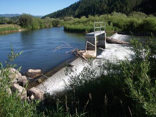
Salt River Diversion Dam
This diversion dam on Wyoming’s Salt River seems pretty low, but it was blocking
access to vital spawning habitat for some trout and other native fish.
 
photo courtesy Trout Unlimited

Across the West, many rivers and watersheds are fragmented by old diversion dams and other irrigation infrastructure. That’s a big problem for trout, which need access to the full range of river habitat in order to thrive. For Trout Unlimited, upgrading these obsolete or inefficient irrigation systems offers a tremendous opportunity to restore rivers. With the help of Orvis funding, TU recently completed an exciting “reconnection” project on the Salt River in west-central Wyoming that should boost both the fish habitat and the fishing.  See the dozens of unique artificial fish habitat models, fish attractors and fish cover used at fishiding.com, the leader in  science based, proven, fish protection.

The Salt River is home to native Yellowstone cutthroat trout, as well as wild rainbows and browns. But they faced a big obstacle: an aging, solitary diversion dam imposed a two-foot-high vertical barrier to fish movement. While adult fish could likely clear the hurdle most of the year, smaller trout and other native species weren’t able to move upstream.

Salt River Fish Ladder
The new fish ladder (in foreground) is a low-tech, low-maintenance solution that
will open some 21 miles of habitat to spawning fish.
 
photo courtesy Trout Unlimited

TU’s Jim Gregory, working with Wyoming Game and Fish and the Eastside Canal Company, saw a golden opportunity to retrofit the structure with a fish ladder and open up some 21 miles of mainstem river habitat. This fall, TU and its partners—including the Wyoming Wildlife and Natural Resource Trust and the U.S. Forest Service—constructed a rock-ramp type fish ladder on the southern side of the diversion structure that provides a low-velocity, low-gradient passageway using a design that is simple, stable, and low-maintenance. The completed ladder allows all native fish species to clear the diversion hurdle and access upstream tributaries—such as Willow Creek, Stump Creek, and Crow Creek—which provide critical spawning and rearing habitatfor native fish.

Sometimes, as on the Salt River, removing a single barrier can dramatically improve miles of habitat for fish. TU is working on dozens of these infrastructure upgrade projects that offer some of the best opportunities to restore rivers for wildlife. As far as we know, no one is making any new rivers, but this might be the next best thing.

For more information on the Orvis/TU Culvert Fund, visit the Orvis Commitment page.

Randy Scholfield is the Director of Communications/Western Water Project for Trout Unlimited. 

Leaser lake gets more fish habitat

Looking back on 2011, the most striking factor affecting the outdoors community in Berks County had to be the lopsided weather we had. Who remembers such a year from the past?See the dozens of unique artificial fish habitat models, fish attractors and fish cover used at fishiding.com, the leader in  science based, proven, fish protection.

Winter ice stretched almost into spring, then rain, rain rain. We were inundated in late August and September by a double-whammy – a hurricane and a tropical storm, followed by summer heat in autumn and a November deer season with days so warm you could hunt in camo t-shirts. For decades to come, weather-wise, 2011 may be the year to which we compare all others.

The saddest events were weather-related too. The flooding, Sept. 7, of Limestone Springs Trout Hatchery by Tropical Storm Lee washed thousands of trout into Upper Tulpehocken Creek which, in turn, were attacked by ill-behaving anglers who angered and frustrated landowners so much they have cut off future access to a once popular portion of the stream.

Flooding also caused an abbreviated pheasant hunting season in 2011. An estimated 35,000 pheasants died or were lost during the autumn floods at the state pheasant farms and the Pennsylvania Game Commission had to cancel late season pheasant stocking.

On the plus side, kids had much to celebrate in 2011. Fishing rodeos, youth hunts and mentored outings, the opening day of the trout fishing season and the annual Youth Field Day rank right up there as highlights.

Rick Heckman of Fleetwood was named 2011 Berks County Outdoor Sports Person of the Year for his volunteer leadership in the Berks Izaak Walton League and with the Federated Sportsman’s Club of Berks County.

The outdoors community made notable efforts to help feed the hungry in Berks last year. From canned goods collections by students to campaigns for frozen meat by Hunters Sharing the Harvest, Mohnton Fish and Game and Berks County Hunters Fighting Hunger much needed food was gathered and donated to the Greater Berks Food Bank and the Reading Salvation Army.

Finally, two area conservation and habitat improvement projects were highlights in 2011. An extraordinary riparian project along Willow Creek, north of Route 73, required many organizations working together to strengthen and repair the path of the beautiful winding stream.

And likewise, just north of the Berks County line near Kempton, the Leaser Lake Heritage Foundation, working with private, public, state and national organizations have nearly completed rehabilitation of Leaser Lake, a popular Berks angler destination. The fish habitat improvements in the lake are among the most advanced in the state.

Last year at this time, anglers were fishing through the ice on area lakes during what was one of the longest ice fishing seasons in many years. Today, there is no sign of ice, an oddity which will likely make 2012’s outdoor highlight list.

Contact Roger Mallon: 610-371-5060 or sports@readingeagle.com.

Nova Scotia cares about fish habitat

Clean Nova Scotia. Inspiring environmental Change

Nova Scotia Fish Habitat Assessment Protocol (NSFHAP)

Nova Scotia Fish Habitat Assessment Protocol (NSFHAP)

Clean Nova Scotia, in collaboration with the NSLC Adopt-A-Stream, is working on the development of a standardized fish habitat assessment methodology for specific use in Nova Scotia. The methodology is intended to be used by the various groups involved in the protection, restoration, and assessment of aquatic ecosystems and will aid in the accurate assessment of fish habitat in our local rivers. This will help identify restoration needs, impacts of poor practises, and protection efforts.

See the dozens of unique artificial fish habitat models, fish attractors and fish cover used at fishiding.com, the leader in  science based, proven, fish protection.

The methodology will incorporate the use of Habitat Suitability Indices (HSI) to provide meaningful and accurate results from data collection in the field. Habitat variables are assessed in the field and are related to water quality, river morphology and hydrology, river banks and riparian vegetation, and benthic macroinvertebrates. The methodology will be modular and varying in the level of depth required so groups with different resources are able to effectively assess their rivers. The methodology will enhance our understanding of fish habitat and populations, lead to effective restoration and protection projects, and improve the health of our aquatic ecosystems.

Counties receive several grants to improve fish habitat

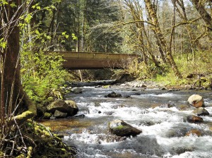
Cowlitz County has a $204,000 grant to remove this bridge on Abernathy Creek.

See the dozens of unique artificial fish habitat models, fish attractors and fish cover used at fishiding.com, the leader in  science based, proven, fish protection.

Several groups that work to improve habitat for endangered fish have been awarded more than $1 million for projects in Cowlitz County. Clark County projects on the Lewis River total $925,383 and money for work in Wahkiakum County totals $361,505.

The grants announced recently by the state Recreation and Conservation Office come from federal and state funds dedicated to fish recovery. The money for the grants comes from the federal Pacific Coastal Salmon Recovery Fund and from the sale of state bonds.

The level of fish funding for most parts of the state has decreased over the past few years. The statewide total of $30 million recently awarded compares to $32 million in 2010 and $42.8 million the year before, said Susan Zemek, communications manager for the RCO.

In addition, grants for fish habitat work in Puget Sound total $13.5 million this year, compared to $33 million a year ago.

Cowlitz County

• Reshaping Abernathy Creek, $486,305. The Cowlitz Indian Tribe will use this grant to remove an abandoned roadbed on the east side of the creek that inhibits full connectivity between the creek and its floodplain, and place logjams in the creek to increase habitat. The tribe will excavate channels through the former roadbed and place logjams in the main channel, allowing the river to meander. The work is on state land.

The tribe will contribute $85,819 in donations of cash, labor and materials.

• Removing an Abernathy Creek Bridge, $204,000. Cowlitz County will use this grant to remove a bridge on an abandoned portion of Abernathy Creek Road. The bridge is 6 1/2 miles up the creek, near Brentwood Road. The bridge constrains the channel and limits the creek’s ability to meander and connect with its floodplain. The county will install logs and tree root wads in the creek and replant its banks after the bridge is removed

Cowlitz County will contribute $36,000.

• Restoring Andrews Tree Farm waterways, $177,401. The Cowlitz Conservation District will use this grant to restore portions of the Coweeman River and a tributary, Turner Creek, on the Andrews Tree Farm. The district will install logs and whole trees in the streams to slow the river, encourage gravel accumulation and create places for salmon to rest and hide from predators. The district also will plant trees along stream banks to shade and cool the water.

The conservation district will contribute $40,000 from a state grant and donations of equipment, labor and materials.

• Restoring Nesbit Tree Farm stream, $89,100. The Cowlitz Conservation District will use this grant to restore a portion of the Coweeman River on the Nesbit Tree Farm, which is about 8 miles up Rose Valley Road. The conservation district will place logs and whole trees in the river to trap sediment on exposed bedrock to improve salmon habitat and cool the water.

The conservation district will contribute $20,000 from a state grant and donations of equipment, labor and materials.

• Restoring the Coweeman River, $124,000. The Conservation District will use this grant to place logs and whole trees in the Coweeman River on the Baxter and Andrews tree farms about 6 1/2 miles up Rose Valley Road to improve habitat for salmon. The logs and trees will slow the river, encourage gravel to accumulate and create places for salmon to rest and hide from predators.

The conservation district will contribute $24,500 from a state grant and donations of equipment, labor and materials.

Clark County

• East Fork of the Lewis River, $212,753. Clark County Public Works will use the money to grade the outlets of two side channels of the river, install logs and root wads that act as juvenile fish habitat, and remove invasive plants and replant with native species. The project will expand side channel habitat by 3,500 square feet. Clark County will contribute $61,891 to the project.

• North Fork of the Lewis River, $401,730. The Cowlitz Tribe will use the money to place logs and jams into two side channels of the river, remove invasive plants along the bank, and replant the area with native trees and shrubs. The tribe will contribute $91,400 from a local grant and donation of labor and materials.

• East Fork of the Lewis River at Daybreak Park, $143,900. Fish First will enhance two side channels of the river, install wood structures in the river for habitat, and replant streambanks with native trees and shrubs at the park. Fish First will contribute $26,100 in cash, labor and materials.

• Eagle Island-North Channel Restoration Project, $167,000. Lower Columbia Fish Enhancement Group will use the money to design a project to restore optimum water flows in the north channel of Eagle Island, which is located in the North Fork of the Lewis River near Woodland. Optimizing the water flow will improve 2.2 miles of high value fish spawning and rearing habitat below Lake Merwin. Pacificorp and the state departments of Natural Resources and Fish and Wildlife are partners.

Wahkiakum County

• Grays River, $226,180. The Lower Columbia Fish Enhancement Group will install wood structures on Columbia Land Trust property in the Grays River to reduce water velocity, create habitat diversity and collect sediments against the toe of eroding stream banks. The structures will create pools, collect flood debris and stabilize the river channel. Additional structures will be placed along more than a half-mile of shoreline to protect important chum salmon habitat in nearby Crazy Johnson Creek. The enhancement group also will remove non-native plants and replant the area with native trees and shrubs.

The enhancement group and Columbia Land Trust will contribute $76,300 in donations of equipment, labor and materials.

• Elochoman River, $135,325. The Wahkiakum Conservation District will use this grant to place logs and tree root wads in the Elochoman River, to slowing the river and creating places for salmon to rest and hide from predators. The logs and root wads also help stabilize the channel by reducing erosion and protecting young trees on the riverbanks. The work will improve salmon habitat along more than a half-mile of the river and create a streamside forest on 4.5 acres.

The conservation district will contribute $39,500 from federal and local grants and donations of equipment and labor.

Can I just toss my Christmas tree on the ice for fish habitat?

When the ice comes, the temptation to place fish attractors often comes to mind especially on a farm pond. If no ice, then a boat might be used. But just weighting down a couple of Christmas trees and dropping them in, may not achieve the best results.

DNR has this to say:  There are many ways to recycle Christmas trees, but tossing on a frozen lake as a way of creating fish habitat has certain requirements — and an uncertain outcome. Instead of waiting for an iced-over lake to thaw so a single Christmas tree can sink to the bottom, Bill James fisheries section chief has this to say.

“They need to be designed, sized and placed appropriately to attract and hold fish.”  He said,  “Large hardwood brush piles work well and last for many years.  Soft woods such as pin or spruce attract fish initially but deteriorate quickly. This is especially true if use Christmas tree are placed singly or just scattered about.”

State laws may apply, depending on the body of water.  Discarding a Christmas tree on a private pond is at the owner’s discretion, but doing so on a public freshwater lake is governed by the Lake Preservation Act. See the dozens of unique artificial fish habitat models, fish attractors and fish cover used at fishiding.com, the leader in  science based, proven, fish protection.

I have placed Christmas trees and have seen the results a couple of years later, both on farm ponds and Lakes  when the water is down.  Christmas trees tend to lay flat on the bottom and shortly become covered with sediment , offering little cover for fish.

On the other hand, a brush pile of hardwood limbs, wired together to maintain it’s shape will be there for years if weighted enough to stay in it’s location.  For further info Google “Fish Attractors” .  There are many home-made designs that work for years and do not deteriorate.

Take a look at fishiding.com. They make artificial fish habitat out of things like reclaimed pvc siding, saving landfill space and helping future generations of fish and fisherman alike.

Hopes Raised for Lake Dredging and fish habitat

test4Lake Gregory dredging tour

Photo by Mike Harris

Lake Gregory dredging tour

Phil Krause, county park planner, points to areas on a map of Lake Gregory where silt has built up over the past few years. Krause was conducting an orientation tour of the lake on Dec. 21 for representatives from California Fish and Game, Lahontan Regional Water Quality Control Board and Lake Gregory Improvement Committee.

A major step toward getting approvals to dredge Lake Gregory was achieved Dec. 21 when representatives from regional agencies visited the lake for an orientation tour.

On hand for the tour were representatives from California Department of Fish and Game, Lahontan Regional Water Quality Control Board, Lake Gregory Improvement Committee and county Regional Parks Department. A representative from the Army Corps of Engineers was scheduled to attend, but canceled at the last minute. See the dozens of unique artificial fish habitat models, fish attractors and fish cover used at fishiding.com, the leader in  science based, proven, fish protection.

“The meeting was an excellent first step in terms of our working to get Lake Gregory dredged,” said Keith Lee, county regional parks director, who was present for the tour. “The different agencies’ representatives were incredibly helpful in providing solutions.”

The group assembled in the North Shore parking lot at 1 p.m., where Phil Krause, county park planner, started the tour with a briefing on past dredging efforts. He explained how silt and debris flowing into the lake from the silt basin near the new county library building has created large sand bars in the swimming area, limiting visitor access.

Another source for the silt is storm drains, especially those near the ball field.

After the briefing, the members walked over to the silt basin to see the area, then moved on to other areas around the lake, including areas near the Leisure Shores Community Center and the ball field where silting is a major issue.

“I think we’re moving along in a good way,” Lee added. “We won’t be able to get away from doing some California Environmental Quality Act (CEQA) work, but we’re looking for ways to work together to dredge the lake and get it back to the condition that I think many in the community would like it to be in.”

Members of the Lake Gregory Improvement Committee who were on hand for the tour included Aaron Creighton, Rick Dinon (who leads the committee), Mick Hill and John Short.

“We have continually emphasized to the regulating agencies that Lake Gregory is not just a county asset, but an important asset to the Crestline and Lake Gregory community,” said Dinon. “The good news is that we’ve encountered a lot of cooperation.”

Committee member Aaron Creighton said he also was pleased with the response from the Fish and Game and Lahontan representatives who took the tour.

“We now have a vastly greater view of what needs to be done,” he said.

Creighton said that in order to get permitted by Fish and Game and Lahontan, the county has to be in compliance with CEQA.

“One of the tricky parts under CEQA is that if we remove habitat, we will have to mitigate the removal,” Creighton said. “There are two areas at Lake Gregory that need to be dredged, and the two have quite a lot of habitat.”

Part of the talk during the tour centered on creating separate habitat areas, and how it might be possible to make habitat areas protected. Other ideas included creating fish habitat areas in the deeper parts of the lake by depositing used Christmas trees weighed down by cinder blocks.

Creighton said one of the comments included that by pulling silt out of the lake, it would help improve the water quality.

“We will need an environmental impact report, and probably have to have a biological report,” he said. “We have heavy-duty problems at this lake.”

By Mike Harris, Reporter

The Radford Becomes a Reef Creating fish habitat

What was once a 553-foot Navy destroyer has become the East Coast’s largest artificial reef. This summer, as tourism and natural resources officials from Delaware, New Jersey and Maryland looked on, the new “reef,” slowly sunk to the bottom of the Atlantic Ocean. The Del-Jersey- Land reef, (named for the three states involved in the project) took about four hours to make its 138-foot descent.

The USS Arthur W. Radford’s final resting place is roughly 28 miles northeast of the Ocean City inlet, midway between the Indian River and Cape May. The Del-Jersey-Land reef is a cooperative venture between the three states to enhance fisheries habitat through decommissioned and retired ships, and railway and subway cars. See the dozens of unique artificial fish habitat models, fish attractors and fish cover used at fishiding.com, the leader in  science based, proven, fish protection.

“It’s going to be a huge economic boost for Ocean City,” says Erik Zlokovitz, the artificial reef coordinator for DNR. “It is expected to attract bluefish, sea bass, weakfish, sharks and tuna, and that will attract charter fleets.”

The Radford was commissioned in 1977 and held a crew of more than 300. It patrolled Venezuela, Panama, Argentina, Brazil, Senegal, Oman, Bahrain, the Azores, Nova Scotia, Italy and Turkey. One of its final missions was deployment during Operation Enduring Freedom. The Radford’s homeport was Norfolk, Va.

The ship was named for Admiral Arthur Radford who served in three wars. He was onboard the USS South Carolina during World War I, in the Office of the Chief of Naval Operations during World War II and was Commander in Chief of the U.S. Pacific Fleet at the outbreak of Korean hostilities.

Taking nearly four hours to sink, the USS Radford is the largest ship to become a reef.

Jill Zarend-Kubatko is the Publication Manager in DNR’s Office of Communication.

Scroll to Top