StructureSpot

Pot Grows Destroy Fish Habitat

Brad Job: Rapacious Grows Destroy Habitat, Undo Restoration Work – January 29, 2012

Saturday, January 28, 2012
Nightmare mosaic photo from a raid in the King Range National Conservation Area. Photo courtesy Brad Job

I’ve been fascinated by water and the organisms that live in it since I was a child. When three years of sea duty made me fall in love with the ocean, I decided to pursue a degree from HSU in Environmental Resources Engineering, which I completed in 1993.

Since then, my career has focused on water quality and water resources. For the past 10 years I have had the honor and privilege of being part of a team of professionals that steward some of our nations’ most spectacular public land. In this occupation I have also been witness to many environmental sins that have occurred as a result of marijuana cultivation.

As a pragmatic environmentalist, it is not my job to deride marijuana or its use. But, similar to the environmental effects of logging, the problem is not necessarily that one grows pot, it’s about how one grows pot.

Regardless of how one feels about marijuana and its legal status, anybody that understands just a little about aquatic ecosystems has to admit that widespread cultivation has bad consequences for fish. It degrades the quality of our rivers and streams, which to me, are the core of what makes northwest California special. See the dozens of unique artificial fish habitat models, fish attractors and fish cover used at fishiding.com, the leader in  science based, proven, fish protection.

In reference to one of last week’s cover stories about illegal excavation and un-engineered fill(‘Shocking’ environmental damage from outdoor grows, Eye, Jan. 18) I can attest that the additional input of sediment eroded from grow-related excavations permanently damages habitat for imperiled salmon and trout populations and undoes the benefits of millions of dollars’ worth of watershed restoration work.

However, increased sedimentation is not the only or necessarily the worst environmental consequence of rapacious pot growing out in the hills.

The giant hunk of failing fill is located right above Bear Creek where it exits the King Range NCA could not be in a worse spot as far as fish habitat goes (notice the clear creek in the upper right corner).

Recent research has shown that 80 to 90 percent of the nitrogen in coastal watersheds historically came from the ocean, much of it in the form of return runs of salmon and steelhead. However, dwindling fish populations and environmentally oblivious pot growers have turned that dynamic on its head.

Now, growers dump hundreds of tons of excess fertilizer into these watersheds annually. The most obvious consequence of fertilizer overuse is increased algal growth, which is most likely why toxic concentrations of blue-green algae have been observed in the Eel River in recent summers. Excessive algal growth kills fish and the organisms that they feed upon.

In addition, outdoor grows frequently discharge rodenticides, insecticides and fungicides into the environment; divert springs and creeks for long distances; and leave vast quantities of trash and black poly-pipe behind.

And then there are the diesel dope grows. These operations often improperly and illegally store large quantities of diesel in plastic tanks that are prone to failure. And those that do use metal tanks almost never have secondary containment and often have leaks and spills.

A pile of dumped cannabis root balls, surely laden with fertilizers and other soil amendments, cascades down the banks of Liscom Slough into sensitive marine habitat last week. Photo courtesy Ted Halstead

It is worth noting that fuel distributors that dispense fuel into such tanks are also committing a felony. If anyone wants to observe the environmental consequences of petroleum spills in aquatic ecosystems, they need only to travel to an urban stream to witness the reduced abundance and diversity of invertebrate species, which are the base of most aquatic food webs.

Then consider the water diversions, air and noise pollution from inefficient generators, and the random dumping of fertilizer-laden potting soil. And I can hardly bear to ponder the sad irony of burning fossil fuel to make light to grow plants in a manner that is literally 99 percent inefficient, all while it is warm and sunny outside.

As long as the marijuana status quo and large profit margins remain, it appears inevitable that some of the worst crimes at marijuana gardens will be environmental ones.

The citizen’s suit provision in the Clean Water Act might be a big enough hammer to change some landowners’ behavior if a motivated team of attorneys and environmental scientists were to respond to a specific incident.

However, the sad fact remains that the underground economy is creating really bad consequences for the increasingly fragile ecology of our rivers and streams. But, if this letter makes only one grower reduce their fertilizer and agricultural chemical use or cause less erosion, the time it took to write it will have been well spent.

Sincerely,

Brad Job, P.E.

Environmental Engineer

Arcata
Keswick beaches get $215K for cleanup and fish habitat restoration

“The Elmhurst Beach project showcases how effective partnerships are contributing to the health of the lake. We are very happy to see that this project will be completed on time and will allow for many to enjoy the beach now and into the future.”

The project will remove failing concrete breakwalls and replace them with boulders in an effort to re-naturalize the shoreline and prevent its further erosion. It will also introduce a natural buffer strip to reduce phosphorus loading and improve fish habitat.

Two Keswick beaches will get the last trickle of federal funds under a four-year, $30-million program that has all but dried up.
The six-figure shoreline restoration project at Elmhurst and Bayview park beaches in south Keswick will be one of the last to get federal funding under the Lake Simcoe Clean Up Fund, which ends in March.
Government house leader and Conservative York-Simcoe MP Peter Van Loan donned an umbrella, tip-toed through mucky construction and braved the rain for this morning’s announcement of $215,500 in federal backing for the estimated $300,000 project that will re-build crumbling breakwalls along 1,000 feet of Lake Simcoe shoreline in Georgina.
The project will remove failing concrete breakwalls and replace them with boulders in an effort to re-naturalize the shoreline and prevent its further erosion. It will also introduce a natural buffer strip to reduce phosphorus loading and improve fish habitat.
The announcement comes as part of the seventh round of projects approved under the $30-million federal program, which was launched in the fall of 2007.
Mr. Van Loan praised Patti Dawson, the president of the Elmhurst Beach Association, who put forward a proposal in 2010, as well as the numerous volunteers, environmental groups and concerned residents for their extensive co-ordination and fundraising efforts.
“The Elmhurst Beach project showcases how effective partnerships are contributing to the health of the lake. We are very happy to see that this project will be completed on time and will allow for many to enjoy the beach now and into the future,” said Mr. Van Loan.
He also pointed to other partners, most notably the environment ministry and conservation authority, that have come on board since the clean-up fund was announced that has allowed the initial $30-million investment to lead to around $100-million worth of projects, which have greatly improved the health of the lake and its watershed.
Of the 300 proposals submitted under the fund, 160 projects have been approved for funding said Richard Simpson, the chairperson of the Protect and Preserve the Environment of Lake Simcoe Committee (PROPEL) — the advisory committee charged with assisting and administering funding under Environment Canada.
“Projects completed to date represent five times more money than what was left in the fund,” said Mr. Simpson. See the dozens of unique artificial fish habitat models, fish attractors and fish cover used at fishiding.com, the leader in  science based, proven, fish protection.
While some of the approved projects have yet to be announced, the original investment, however, is all but spent and no future clean-up funding should be expected, Mr. Van Loan added.
He said the “one-time commitment” from the federal government has produced real results, but there is plenty left to do with respect to the health of the lake and local municipalities and the province will have to step up to ensure the valuable work continues in the future.
Michelle Rempel, the parliamentary secretary to the environment minister, was pleased to be a part of this morning’s announcement and said the fund highlights the importance of environmental stewardship and local economic growth, especially since Lake Simcoe generates roughly $200 million of economic activity annually.By Heidi Riedner

New reefs for fish habitat in Maryland

Artificial reefs for fish habitat
fish attractors

The new fishing season might seem like a long way off but we’re really only a couple months away from when folks will begin extracting fishing rods from attics and sheds, pulling winter tarps from their boats, and reviewing their charts, just to make extra sure they’re set and ready for the fun times ahead. The natural optimism found in most anglers may foster aspirations for a new fishing season filled with beautiful weather and stringers full of big fish. But in these times when it seems fishermen are so often hampered by political, environmental, and economic issues, even the most optimistic angler can sometimes have trouble keeping a smile on their face when the winter news carries so many headlines of “doom and gloom.” So it’s always refreshing to hear some good news about positive developments within the fishing industry. On that note, let me reintroduce to you the Ocean City Reef Foundation and MARI. See the dozens of unique artificial fish habitat models, fish attractors and fish cover used at fishiding.com, the leader in  science based, proven, fish protection.

Its activities may not always capture front-page headlines, but since 1997 the Ocean City Reef Foundation has been busy creating and enhancing offshore fish habitat through an ever-expanding network of artificial reefs. From boats to barges, cable to concrete, tanks to trains, in recent years Reef Foundation administrators have strategically submerged so much material off our shores that give fish traveling through Maryland waters a reason to reside and reproduce off our coast.

There have always been artificial reefs off Ocean City. But, until the Reef Foundation got to work, offshore structure was restricted to a small handful of boats and ships that accidentally sank, or structure that was intentionally put down by a few well meaning anglers on a very limited basis. Consequently, local wreck fishing used to be practiced by a relatively small segment of local anglers who, through years of trial and error, acquired the coordinates to the bulk of offshore structure. Since no one wants to schedule their day around fishing a certain wreck and then find someone else already anchored over it, once obtained these coordinates were very seldom shared with other fishermen. With such limited opportunities, local wreck fishing was destined to remain one of Ocean City’s best-kept secrets.

Not any more. The OC Reef Foundation has been so successful at seeding the waters that fishermen no longer have a need to keep a good thing to themselves. There’s plenty of places to fish, and plenty of fish once you get there.

When structure goes down it immediately begins to provide safe habitat for aquatic life. In relatively short order, entire living communities can establish themselves on, in, and around the structure. In areas where the ocean floor was little more than smooth bottom there becomes a living reef and complete food chain, from tiny microscopic plants and animals to large predators. The Reef Foundation is just getting warmed up; they sink structure all year and have lots more on the agenda.

A few years ago Maryland also got into the reef building business when they kicked off the Maryland Artificial Reef Initiative (MARI), which includes over 60 private, state, and federal partners, and acts as a funding mechanism (using private and corporate donations) for reef development in Maryland. It’s a volunteer organization dedicated to preserving, restoring and creating fish habitat in tidewater Maryland. Funding for MARI comes from the Coastal Conservation Association, Maryland Department of Natural Resources and the coalition of donors and partners. MARI brings together a coalition of diverse stakeholders to accomplish meaningful and measurable goals that not only benefit the sport fishing industry, but also provide priceless marine habitat. Last summer, MARI had a hand in the offshore sinking of the 564-foot warship Radford which is now in striking distance of Maryland, Delaware, and New Jersey fishermen.

Though spring is still few months away, sooner or later it will be here and happy anglers will once again put to sea in hopes of enjoying their best fishing season ever. Fishermen should take comfort in knowing that the Ocean City Reef Foundation and MARI are working hard to ensure that such hopes can indeed become reality. For more information about the Reef Foundation visitwww.ocreeffoundation.com, or see www.dnr.state.md.us for details on MARI.

Written by
Mark Sampson

Kids learn to improve and protect habitat

See the dozens of unique artificial fish habitat models, fish attractors and fish cover used at fishiding.com, the leader in  science based, proven, fish protection.
California, Nevada and Klamath Basin

Photo: USFWS

Schoolyard Habitat Program

Schoolyard Habitat ProgramThe Schoolyard Habitat Program helps teachers and students create wildlife habitat at their own schools. Typical projects include: wetlands, meadows, forests and variations based on specific ecoregions.

Many projects are planned through multiple phases and change over time as children from various classes build upon the existing work of past students.

We work with your school to provide:

  • technical assistance and project guidance
  • teacher training,
  • develop written materials

Our goal is to provide technical and organizational assistance to school, so they can create outdoor classrooms that are effective as educational tools in addition to being a sustainable habitat for many years to come.

Please download the following Fact Sheet for more information on the Schoolyard Habitat Program:
Schoolyard Habitat Fact Sheet (.pdf)

Fish love Snags and snags create habitat

Re-snagging the Goulburn to increase native fish habitat and improve recreational fishing opportunities between Seymour and Nagambie.

The Goulburn Broken Catchment Management Authority (CMA) is working along the Goulburn River between Seymour and Nagambie in the coming weeks to increase the amount of large woody habitat, or snags, in the Goulburn River, with the aim to increase in the native fish population and diversity in this section of the river.

Funded by the Victorian Government, through revenue from Recreational Fishing Licenses to improve recreational fishing in Victoria and the Goulburn Broken CMA, the snags are being placed in the Goulburn River, downstream of the Hume Freeway Bridge near Seymour. The works that are being carried out will lead to an increase in habitat for native fish in the area and an improvement in catch rates for recreational fishers.

Goulburn Broken CMA River Health Projects Coordinator, Mr Jim Castles explains, “Native fish rely heavily upon instream habitat such as tree roots, logs and branches called ‘snags’. Since European settlement, our streams and rivers have been de-snagged, in the belief this would increase water flow and quality. We now know this is not the case.”

Native fish ecologists from the Murray Darling Basin Authority estimate that fish populations have declined by 90% since European settlement. There have been many threats to native fish including removal of in-stream and riparian habitat and flow modification.

Snags are the inland equivalent of coastal reefs and provide habitat for native fish and other animals such as tortoises and native water rats. Native fish use them to shelter from fast currents and sunlight and take refuge from predation. Native fish also use snags as feeding and spawning sites, and as nursery areas for juvenile fish.

Recent fish surveys within the Murray Darling Basin have found that 80% of Murray Cod are found within 1 metre of a snag. All large bodied freshwater native fish use snags as habitat.

“Re-snagging is a sound management intervention we can use to restore native fish habitat to our waterways, and results so far suggest that native fish populations respond strongly as a result. Re snagging on its own, however, is unlikely to be the sole driver in native fish recovery in the Goulburn River. The key is to better manage our riparian zones by fencing to restrict stock access and protect native vegetation, and revegetating degraded areas so there will be a constant natural supply of snags in the future” says Mr. Castles. See the dozens of unique artificial fish habitat models, fish attractors and fish cover used at fishiding.com, the leader in  science based, proven, fish protection.

The areas to be re-snagged have been identified via in-stream habitat mapping undertaken in 2011 by scientists from the Arthur Rylah Institute (ARI) in the Goulburn River between the Mitchellstown and Hume Freeway Bridges to identify areas that have a low density of snags. The sites where the Goulburn CMA carry out re-snagging are being selected based on priority zones identified by ARI as a result of this mapping, and access to the waterway within these zones.

The fallen trees used for the re-snagging project have been sourced from a number of nearby locations, including the Nagambie Bypass and a public reserve in Seymour. The Goulburn Broken CMA and its contractors work to rigorous guidelines that have been developed in other locations where re-snagging has been carried out over many years.

“The snags will be secured safely and positioned in a way that does not block the river channel to ensure fishing boats can still travel along the river,” explains Mr Castles “The snags will have very little or no net impact on water flow and will enhance native fish habitat, thereby leading to a more robust native fish community, which will result in huge benefits for recreational fishers in our region.”

This project is funded by the Department of Primary Industries Recreational Fishing Licence Grants Scheme, which uses revenue raised from the sale of recreational fishing licences to fund projects that directly improve recreational fishing in Victoria.

Snags on the riverbank prior to placement. Photo: Jim Castles, Goulburn Broken CMA

Fraser River fish habitat threatened by gravel extraction

  Fraser River fish habitat threatened by gravel extraction

Approximately 280,000 cubic metres of gravel accumulated in the active channel of the river, this was largely offset by significant losses (4 million cubic meters) of over-bank sand on islands and river edges, resulting in little net gain of sediment. (Credit: janheuninck via Flickr)

B.C.’s Fraser River has become the battleground for the gravel industry and conservation groups fighting to protect one of the world’s most productive fish habitats. See the dozens of unique artificial fish habitat models, fish attractors and fish cover used at fishiding.com, the leader in  science based, proven, fish protection.

The Fraser has been a source of gravel for B.C. construction for decades. However, Fisheries and Oceans Canada (DFO) placed a moratorium on gravel extraction in the mid 1990s due to concerns about fish and fish habitat. Not long after the freeze, the B.C. Provincial government began to argue that gravel removal from the Fraser was necessary for flood protection as “massive” gravel accumulations were, allegedly, causing the river bed to rise. A series of public meetings was held to debate the issue and experts were called in to assess the scope of the problem.

Dr. Michael Church, a professor of Geography at the University of British Columbia, provided the most compelling testimony on how gravel and sand enter and move through the gravel reach. He estimated that while approximately 280,000 cubic metres of gravel accumulated in the active channel of the river, this was largely offset by significant losses (4 million cubic meters) of over-bank sand on islands and river edges, resulting in little net gain of sediment.

The B.C. government and proponents of the gravel industry incorrectly interpreted this to mean that 280,000 cubic meters of gravel and sand entered the gravel reach each year and merely “piled up” in the river causing a rise in riverbed elevation that would, over time result in increased flood risk. These groups argued that lives and property were at risk and pushed for DFO to lift the moratorium on gravel extraction.

In 2004, a five-year federal-provincial agreement was reached to allow removal of up to 500,000 cubic metres of gravel in each of the first two years and up to 420,000 cubic metres in the following three years. The agreement was touted as a long-term plan for reducing the flood hazard risk in the lower Fraser River.

Critics argued that gravel removal was only taking place in areas where it was easily accessible to industry and that removal from the targeted areas provided no flood protection benefits whatsoever. In addition, fish and fish habitat were paying the price. In one case, at a location known as Big Bar, removal operations undertaken in 2006 resulted in the de-watering of thousands of salmon redds (nests) and the demise of possibly millions of young salmon which were just about to emerge from the gravel. There was evidence to suggest that similar losses of fish had occurred at other sites as well.

The Fraser River is also home to the white sturgeon, listed by the Committee on the Status of Endangered Wildlife in Canada (COSEWIC) as endangered, with gravel removal identified as one of the key threats affecting this species.

By David Suzuki.org

Tweed river fish habitat in good hands

Jim Ryan, a state river scientist, surveys a restoration project on the Tweed River in Pittsfield on Friday, Dec. 2, 2011. Floods triggered by Tropical Storm Irene sent the river shooting into a new path that threatened a mill downstream. Road crews seeking gravel further altered the river, making it more unstable. To restore the Tweed, river scientists redesigned a 1,800-foot stretch of the stream, to make it more stable, protect private property and restore fish habitat. Ryan stands on gravel used to fill in the Irene flood channel. That area will be the river's new floodplain -- a relief valve during heavy rains and spring snowmelt. The river flows in its new, more stable channel farther from houses and Vermont 100.
Jim Ryan, a state river scientist, surveys a restoration project on the Tweed River in Pittsfield on Friday, Dec. 2, 2011. Floods triggered by Tropical Storm Irene sent the river shooting into a new path that threatened a mill downstream. Road crews seeking gravel further altered the river, making it more unstable. To restore the Tweed, river scientists redesigned a 1,800-foot stretch of the stream, to make it more stable, protect private property and restore fish habitat. Ryan stands on gravel used to fill in the Irene flood channel. That area will be the river’s new floodplain — a relief valve during heavy rains and spring snowmelt. The river flows in its new, more stable channel farther from houses and Vermont 100. / CANDACE PAGE, Free Press

Written by
Candace Page


PITTSFIELD — Jim Ryan stood with Ray Colton on the banks of the Tweed River on Oct. 7 and shook his head, more in resignation than disbelief. He’d seen too many places like this in the last month.

“What a mess,” he said. He made a note in his notebook: “Colton’s mill site: Site is hammered.”

The river running past Colton’s firewood mill looked more like an abandoned gravel pit than a babbling brook.

On Aug. 28, Tropical Storm Irene had ravaged this stretch of the Tweed, a scenic stream that borders Vermont 100 between Killington and Stockbridge. Highway crews compounded the damage. Desperate for gravel to repair the washed-out highway and its broken bridges, they drove excavators and dump trucks into the river and scooped out tons of stone.

The tracks of heavy equipment could still be seen as ridged indentations on gravel bars. Much of the river’s water ran in a stony ditch gouged out by the road crews, but the rest trickled in multiple threads through the gravel islands.

Just upstream, the river had jumped its bank, eating up the field behind Sarah and Gordon Gray’s house and carving a new channel that barely missed Colton’s mill. More than 100 feet of riverbank snowmobile trail had disappeared.

Colton was worried about what would happen in the next high water.

“I’m afraid the river wants to come right through the yard,” he said, referring to his millyard with its stacks of logs. He’d spent the night of Irene sleeping in a camper at the mill to keep an eye on the river.

Ryan shared Colton’s concern about damage from a future flood, but had other worries as well.

“From a water quality and fish habitat perspective, the conditions were just horrible,” he said later. “Think about fish trying to stay cool in the middle of summer. Instead of deep shaded pools, they would have this shallow, braided stream.

“Yes, the river might have healed itself, but it could have taken decades. Something needed to be done,” he said.

Irene had jerked Ryan, a stocky, soft-spoken man, from his job as a state watershed coordinator to join the state’s lightly staffed River Management Program. He had spent the weeks since criss-crossing the White River watershed to survey river damage and to provide guidance to towns about rebuilding bridges and culverts in more flood-resistant ways.

Before the arrival of Ryan and his peers, road crews had torn up river channels across central and southern Vermont. Vermonters were treated to the surreal site of excavators, backhoes and dump trucks chugging through trout streams to remove whole shoals of gravel.

Much of this post-Irene emergency work did not just destroy fish habitat. It left rivers unstable — prone to severe erosion of their banks and sudden changes in course during high water — and thus potentially dangerous.

The challenge facing Ryan at Colton’s mill and elsewhere was: What do we do now? How do we restore a river? How do we resolve the conflict between the laws of physics governing a river’s natural behavior with the need to protect homes, roads and businesses on the bank?

And how do we do all this given shortages of money, manpower and work days before winter?

‘Don’t fight the river’

The traditional Vermont response to flood damage has been to dredge out new gravel deposits and to keep water moving past private property by digging out a straight river channel with banks armored in stone.

Over the last 20 years, river scientists have learned that such “solutions” come with a cost and often do not work. At best, a channelized, armored river will need frequent maintenance. At worst, the river’s potential for damage will simply move downstream.

“The idea is you don’t want to fight to create a river channel that the forces of nature will constantly work against,” says Shayne Jaquith, the state’s river restoration scientist.

After looking at the Tweed, Ryan persuaded Colton not to insist on a quick, Band-Aid fix that would be unlikely to last. Then he won agreement from Colton, the state Transportation Agency and the town of Pittsfield to share the cost of some restoration.

Ryan hoped to resculpt 1,800 feet of river, giving it something close to the form, slope and dimensions the river would find, in time, if it were left alone.

If the design worked, the river would be stable, that is, powerful enough to move sediment downstream — one of a river’s jobs — but not so powerful it cut a deeper and deeper channel or collapsed its banks.

But “stable” in a river system doesn’t mean unchanging. Rivers naturally migrate across a valley landscape, eroding earth from the outside of bends, depositing dirt and stones on the inside of bends where water moves more slowly.

Compromise would be necessary. Here, as farther downstream, the Tweed could not be allowed to migrate willy-nilly because that would endanger the highway and buildings on its banks.

Meanwhile, across Vermont, river management engineers were facing dozens of similar situations — rivers used as gravel mines, landowners calling for new river channels to be moved away from their homes, anglers complaining about the destruction of fish habitat.

Winter loomed. Towns, already facing million-dollar road repair bills, were unable to undertake expensive river restoration projects. The state lacks sufficient staff to design and carry out multiple complicated restorations.

Compromise was required everywhere. Mike Kline, director of river management for the state, compared the dilemma to the building of a new home on a limited budget: The first priority is to get the superstructure right; interior details can wait.

“The basic work we could do was to get people to stop digging — stop digging an 80-foot-wide channel in a 30-foot-wide stream! We would redirect them to fill back in to get the dimensions of the channel right. Get that superstructure right. With that, the river can rebuild over time,” he said.

Resculpting a river

On the Tweed, Ryan had commitments for funding that he hoped would allow him to do a more complete restoration.

He and Jaquith assembled a survey crew to spend a day creating a topographical map of the river, measuring the width, depth and slope of the post-Irene channel.

They compared their measurements to what river science, and data about the Tweed watershed, indicated should be the stream’s natural dimensions. They also used U.S. Geological Survey data to determine how much “bedload” — gravel and sediment — the river should have the capacity to move downstream.

It was clear that big changes were needed.

At the point in the watershed where Colton’s mill sits, the Tweed’s channel should be about 45 feet wide and 2.5 feet deep, as measured from the top of one bank to the top of the opposite bank.

The post-Irene, post-dredging, channel was more than twice as wide and half as deep. The river had lost some of its bend, so it flowed at too steep a slope.

In the end, Jaquith designed a new path for the Tweed much like the one the river had chosen for itself in the years before Irene.

He called for the new channel cut by the river across the Grays’ field to be filled in. The ditch excavated post-Irene would disappear. Mathematical formulas determined the radius and frequency of three new bends that would send the river past the Grays’ house and Colton’s mill in a series of lazy curves.

Those meanders decreased the slope of the river, slowing down the force of the water. In one place, a bend would bring the river against immovable ledges on the far side of the narrow valley, a place where a good fishing hole might develop. Where another bend curved toward Colton’s mill, riprap would protect the bank from erosion.

The newly carved river channel would be 45 feet across. The rest of the 150-foot-wide gravel bed left after Irene would become the river’s new floodplain, a pressure relief valve to hold water during spring snowmelt and moderate floods.

At the tail end of November, the excavators went to work.

‘We’re 80 percent there’

As the heavy equipment finished its work on Dec. 2, the river landscape looked raw, as though newly scraped by a glacier. A wide expanse of gravel, the new floodplain, stretched up-river in the place of the Irene flood channel.

Out beyond the gravel plain, the river meandered gracefully back and forth across the valley within well-defined banks. Driftwood tree trunks had been anchored in the riverbank, their root systems sticking out into the water where they would absorb some of the force of the water and thus protect the banks from erosion. Rocks protected the stretch of shore beside Colton’s mill.

“In the end, I was satisfied,” the mill owner said last week, although he said it had been necessary for him to rein in the river scientists’ plans to import boulders to place in the stream to dissipate more stream energy and create fish habitat. See the dozens of unique artificial fish habitat models, fish attractors and fish cover used at fishiding.com, the leader in  science based, proven, fish protection.

“I paid my share, it got done and the river looks pretty good,” he said.

Jaquith and Ryan were satisfied they had done the best they could, within the constraints of an $11,000 budget and — ironically — a shortage of gravel to better define the channel edges at the far end of the 1,800-foot reach. Too much gravel had been dredged out of the waterway.

“What I saw there, that first day, was an ugly thing — I remember thinking, ‘How can someone do something like this to a river, even though it wasn’t done in malice?’ — but what came out of it I hope can be a model,” Ryan said last week.

“We restored a river in a collaborative way. All the parties responsible for the damage came together and did the right thing. We didn’t have to fine anybody or go through environmental enforcement. We have a better stream for stability, for protecting infrastructure, for fish.

“It wasn’t a perfect fit, but it was a good start,” he said.

Reconnecting Habitat on Wyoming’s Salt River

Salt River Diversion Dam
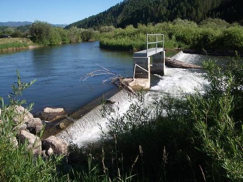
This diversion dam on Wyoming’s Salt River seems pretty low, but it was blocking
access to vital spawning habitat for some trout and other native fish.
 
photo courtesy Trout Unlimited

Across the West, many rivers and watersheds are fragmented by old diversion dams and other irrigation infrastructure. That’s a big problem for trout, which need access to the full range of river habitat in order to thrive. For Trout Unlimited, upgrading these obsolete or inefficient irrigation systems offers a tremendous opportunity to restore rivers. With the help of Orvis funding, TU recently completed an exciting “reconnection” project on the Salt River in west-central Wyoming that should boost both the fish habitat and the fishing.  See the dozens of unique artificial fish habitat models, fish attractors and fish cover used at fishiding.com, the leader in  science based, proven, fish protection.

The Salt River is home to native Yellowstone cutthroat trout, as well as wild rainbows and browns. But they faced a big obstacle: an aging, solitary diversion dam imposed a two-foot-high vertical barrier to fish movement. While adult fish could likely clear the hurdle most of the year, smaller trout and other native species weren’t able to move upstream.

Salt River Fish Ladder
The new fish ladder (in foreground) is a low-tech, low-maintenance solution that
will open some 21 miles of habitat to spawning fish.
 
photo courtesy Trout Unlimited

TU’s Jim Gregory, working with Wyoming Game and Fish and the Eastside Canal Company, saw a golden opportunity to retrofit the structure with a fish ladder and open up some 21 miles of mainstem river habitat. This fall, TU and its partners—including the Wyoming Wildlife and Natural Resource Trust and the U.S. Forest Service—constructed a rock-ramp type fish ladder on the southern side of the diversion structure that provides a low-velocity, low-gradient passageway using a design that is simple, stable, and low-maintenance. The completed ladder allows all native fish species to clear the diversion hurdle and access upstream tributaries—such as Willow Creek, Stump Creek, and Crow Creek—which provide critical spawning and rearing habitatfor native fish.

Sometimes, as on the Salt River, removing a single barrier can dramatically improve miles of habitat for fish. TU is working on dozens of these infrastructure upgrade projects that offer some of the best opportunities to restore rivers for wildlife. As far as we know, no one is making any new rivers, but this might be the next best thing.

For more information on the Orvis/TU Culvert Fund, visit the Orvis Commitment page.

Randy Scholfield is the Director of Communications/Western Water Project for Trout Unlimited. 

Michigan firm expanding with Fishiding Habitat products

This Michigan company has the help you need to manage your lake or pond. Get professional advice with proven results along with cost effective methods and products at Tri-county Aquatics.

Tri-County Aquatics, Inc. is a full service aquatic management company, specializing in superior waterway management programs. The friendly staff regularly controls nuisance aquatic vegetation, weeds, and algae in small backyard ponds, inland lakes, canals, marinas and other waterways. Tri-County Aquatics’ goal is to create a management program designed to control your specific aquatic need. With years of experience in the aquatics industry, These folks have the solution to your pond and lake needs.

See the dozens of unique artificial fish habitat models, fish attractors and fish cover used at fishiding.com, the leader in  science based, proven, fish protection.

Tri-County Aquatics, Inc. services include, but are not limited to:

  • Aquatic Vegetation Control
  • Aeration Systems (sales, service, and installations)
  • Floating Fountains (sales, service, and installations)
  • Water Quality Testing
  • Pond and Lake Consulting
  • Fish Stocking & Population Management
  • Equipment Sales
  • Pond & Lake Consulting

    Problems with your pond or lake? Contact Tri-County Aquatics and have one of their trained technicians meet with you to set up the best management program for your waterway. Whether you’re dealing with nuisance aquatic vegetation, high bacteria levels, or just looking for a beautiful floating fountain or some professional advice, we can help you with any of your aquatic needs.

  • Tri-County Aquatics, Inc. specializes in the control of nuisance aquatic vegetation in ponds, lakes, canals, marinas and many other waterways. 
  • Aquatic vegetation can inhibit the recreational uses of any waterway, and become very aesthetically unappealing.
  • Tri-County Aquatics, Inc. has years of experience in the aquatics industry. Controlling aquatic vegetation is our specialty. With hundreds of water bodies being managed by us annually, we have the experience, knowledge, and tried management techniques to solve your waterway problems.
  •  Full service water testing for bacteria levels, organics, and total water quality index. 
  • The products used to control nuisance aquatic vegetation, whether herbicides or algaecides, are all approved and labeled for aquatic use by the United States Environmental Protection Agency and the Michigan Department of Agriculture. All waterway treatments and applications are performed by trained, state certified, and licensed applicators. We use specialized and waterway specific management techniques to manage your waterway in the most efficient and effective manner.

New Vessels for Aquaculture Regulation in British Columbia

CAMPBELL RIVER, BRITISH COLUMBIA–(Marketwire – Jan. 9, 2012) – The Honourable Keith Ashfield, Minister of Fisheries and Oceans, welcomed six British Columbia-made vessels into the departmental fleet today.

“Our government is proud to ensure that Fisheries and Oceans Canada has the tools it needs to regulate the aquaculture industry in British Columbia and ensure that it operates in a sustainable and environmentally responsible manner,” Minister Ashfield said. “We are committed to an economically and ecologically viable fishing and aquaculture industry across Canada.”

The six vessels, of various sizes and construction, are dedicated to the B.C. Aquaculture Regulatory Program and carry out aquaculture regulatory and monitoring activities. Three of the vessels are used by aquaculture management staff for auditing and monitoring aquaculture sites, and three are used by aquaculture fishery officers for enforcement and compliance inspections.

As the majority of aquaculture operations are located along the coast of Vancouver Island and in mainland inlets, and most are inaccessible by car, ensuring DFO staff are able to move freely on the water is an important aspect of regulating the aquaculture industry in B.C. The new Conservation and Protection vessels will allow fishery officers to respond quickly to events or public reports of potential concerns at farm sites, while staff on the aquaculture management vessels can deploy tethered remote underwater vehicles for site inspections and conduct and analyze benthic (ocean bottom) sampling.

Nationally, aquaculture production has increased four-fold in the past 20 years. Approximately 70 per cent of all Canadian aquaculture products are sold to foreign markets, and the world increasingly depends on aquaculture as an essential food source. In fact, globally, half of all fish and seafood is now farmed. British Columbia contributes the most farm-raised fish and seafood to Canada’s output annually.

Backgrounders:

  • SIX DFO AQUACULTURE VESSELS FOR B.C.
  • FISHERIES AND OCEANS CANADA’S FIRST YEAR AS PRIMARY REGULATOR FOR BRITISH COLUMBIA’S AQUACULTURE INDUSTRY

SIX FISHERIES AND OCEANS CANADA AQUACULTURE VESSELS FOR BRITISH COLUMBIA

Fisheries and Oceans Canada has purchased six B.C.-made vessels to support its effective regulation of aquaculture activities in the province. As the regulator and manager of aquaculture in B.C., Fisheries and Oceans Canada is responsible for ensuring that the industry is abiding by the conditions of licence established for each aquaculture site in the province, adhering to the Pacific Aquaculture Regulations, and following strict guidelines for operations. These vessels will allow departmental staff to carry out these new duties.

Of the six vessels, three are being used by aquaculture management staff to undertake regular audit and monitoring activities at aquaculture sites, and three are tasked with aquaculture fishery officer enforcement activities.

Aquaculture Management Program

Three B.C.-made vessels, the Salmon Bay, the Sturgeon Bay, and the Oyster Bay, are being used by aquaculture management staff for audit and monitoring activities:

  • Fish health management inspections
  • Sea lice audits
  • Stream surveys
  • Benthic (ocean floor) sampling and remote-operated vehicle assessments
  • Facility inspections

The three program management vessels are named after the three sectors of the fish farming industry: marine finfish, shellfish, and freshwater aquaculture.

The Salmon Bay and the Sturgeon Bay carry departmental staff to fish farm sites for the purpose of conducting finfish facility inspections, fish health inspections, and soft-bottom benthic sampling. In addition, the vessels can deploy a remote-operated vehicle, which is used to capture video of hard-bottom benthic (ocean floor) environments for assessment purposes.

The Salmon Bay has an onboard work station that supports field testing of various benthic samples and the collection of samples for future analysis.

The Oyster Bay is used primarily to transport departmental staff to and from aquaculture facilities to conduct fish health and shellfish farm inspections.

Enforcement Program

The regional Conservation and Protection Branch is operating its three new vessels to transport fishery officers to aquaculture facilities to conduct announced and unannounced site inspections and enforce compliance with the Pacific Aquaculture Regulations and the Fisheries Act.

The MacLeod Bay is a 9.7-metre rigid-hull inflatable boat. It is named for J. Ronald MacLeod, a retired departmental employee and Officer of the Order of Canada who was recognized for his contributions to Pacific fisheries.

The Weaver Bay is a 9.7-metre rigid-hull inflatable boat. It is named after Kenneth E. Weaver, a Pacific Region fishery officer who died in an airplane accident in the line of duty on September 2, 1948.

The Max Bay is a six-metre aluminum vessel. It is named after Max Tscharre, a well-respected retired fishery officer dedicated to the protection of fish and fish habitat. This vessel is the “sister ship” to the Oyster Bay, with similar design, features and equipment.

FISHERIES AND OCEANS CANADA’S FIRST YEAR AS PRIMARY REGULATOR FOR BRITISH COLUMBIA’S AQUACULTURE INDUSTRY

In December 2010, Fisheries and Oceans Canada assumed primary responsibility for the regulation of the aquaculture industry in B.C., including the licensing of marine finfish, shellfish, and freshwater aquaculture sites, as well as enhancement facilities. Staff were hired to implement and undertake the federal B.C. Aquaculture Regulatory Program, with the majority of positions located on Vancouver Island. The program provides economic stimulus to coastal communities, as its employees work to ensure that the aquaculture industry is operating in an environmentally sustainable fashion.

After its first full year in operation, the program has achieved success in a number of areas:

  • A total of 104 inspections were conducted at marine finfish aquaculture sites by departmental field biologists and fishery officers to assess compliance with their site’s conditions of licence, and applicable acts and regulations;
  • Conditions of licence inspections were conducted at 140 shellfish and 22 freshwater aquaculture operations, and fishery officers also conducted 18 compliance inspections;
  • More than 65 marine finfish site health audits (including sea lice audits) were conducted;
  • Benthic (ocean bottom) environmental audits were conducted at 23 operational marine finfish farm sites;
  • An enhanced Atlantic Salmon Watch Program has surveyed six rivers for the potential presence of Atlantic salmon escapes;
  • Two new freshwater aquaculture licences were issued;
  • A pre-site audit was conducted for one proposed new farm site; and
  • A total of 12 marine finfish licence applications and amendments were processed.

In 2011, the Department also initiated consultations on the development of draft Integrated Management of Aquaculture Plans. These consultations will continue in 2012: http://www.pac.dfo-mpo.gc.ca/consultation/aquaculture/index-eng.htm.

As part of its commitment to transparency, the Department undertakes regular public reporting of fish health, sea lice levels, disease presence, and other data on the environmental performance of the aquaculture industry in B.C. Information is regularly posted to the Department’s website: http://www.pac.dfo-mpo.gc.ca/aquaculture/index-eng.htm.

The British Columbia aquaculture industry provides an estimated 6,000 jobs and over $224 million in wages for British Columbians. Salmon farming has grown to take its place as the province’s largest agricultural export, generating $800 million in economic output. Cultured shellfish production has reached 10,000 tonnes with a landed value of $21.7 million.

See the dozens of unique artificial fish habitat models, fish attractors and fish cover used at fishiding.com, the leader in  science based, proven, fish protection.

Contact Information

  • Fisheries and Oceans Canada
    Michelle Imbeau
    Communications Advisor, Pacific Region
    604-666-2872 or Cell: 604-219-5730

    Fisheries and Oceans Canada
    Barbara Mottram
    Press Secretary
    Office of the Minister
    613-992-3474
    http://www.dfo-mpo.gc.ca

Scroll to Top